
-
Federal
NACP North American Forest Dynamics Project: Forest Disturbance and Regrowth Data
National Aeronautics and Space Administration —
This data set provides the results of time-series analyses of Landsat imagery for 55 selected forested sites across the conterminous U.S.A. The output is a pair of... -
Federal
Global Gridded Soil Phosphorus Distribution Maps at 0.5-degree Resolution
National Aeronautics and Space Administration —
This data set provides estimates of different forms of naturally occurring soil phosphorus (P) including labile inorganic P, organic P, occluded P, secondary mineral... -
Federal
Global Vegetation Types, 1971-1982 (Matthews)
National Aeronautics and Space Administration —
The global vegetation type data of 1 x 1 degree latitude and longitude resolution were designed for use in studies of climate and climate change. Vegetation data were... -
Federal
ISLSCP II EDGAR 3 Gridded Greenhouse and Ozone Precursor Gas Emissions
National Aeronautics and Space Administration —
The EDGAR (Emission Database for Global Atmospheric Research) database project is a comprehensive task carried out jointly by the National Institute for Public Health... -
Federal
ATom: In Situ Atmospheric Water Vapor from the Diode Laser Hygrometer, Version 2
National Aeronautics and Space Administration —
This dataset provides the concentrations of water measured by the Diode Laser Hygrometer (DLH) flown on the NASA DC-8 during the ATom 1-4 campaigns from 2016 - 2018.... -
Federal
NACP: Urban Greenhouse Gases across the CO2 Urban Synthesis and Analysis Network, V2
National Aeronautics and Space Administration —
This dataset provides hourly urban greenhouse gas measurements for cities in the CO2 Urban Synthesis and Analysis (CO2-USA) Data Synthesis Network for 2000 to 2019.... -
Federal
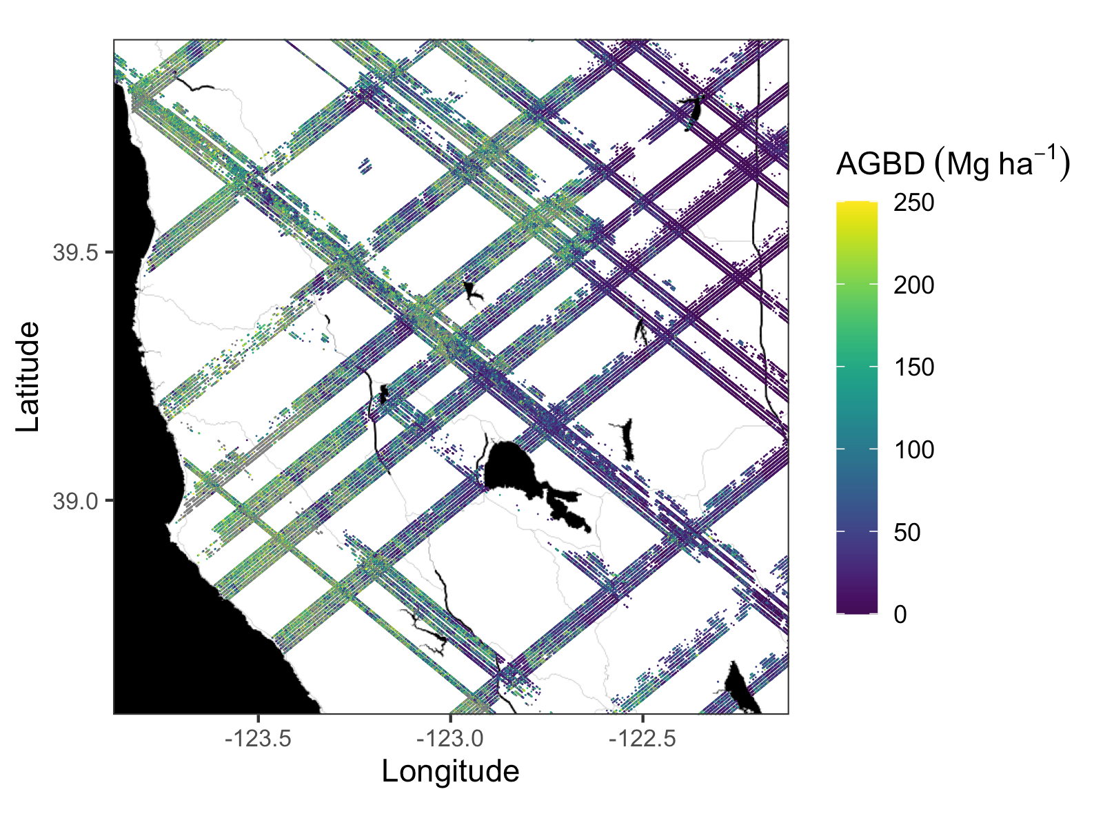
GEDI L4A Footprint Level Aboveground Biomass Density, Golden Weeks, Version 1
National Aeronautics and Space Administration —
This dataset contains Global Ecosystem Dynamics Investigation (GEDI) Level 4A (L4A) predictions of the aboveground biomass density (AGBD; in Mg/ha) and estimates of... -
Federal
SAFARI 2000 Historical Fire Maps, Kruger National Park, 1992-2001
National Aeronautics and Space Administration —
Kruger National Park (KNP) was established in 1898 to protect wildlife on nearly 2 million hectares of the South African Lowveld. The climate in this region of South... -
Federal
Sources of Methane Emissions (Vista-CA), State of California, USA
National Aeronautics and Space Administration —
This dataset provides spatial data products with identified and organized locations of potential methane (CH4) emitting facilities and infrastructure spanning the... -
Federal
BOREAS HYD-06 Moss/Humus Moisture Data
National Aeronautics and Space Administration —
This data set contains water content measurements of the moss/humus layer, where it existed. These data were collected along various flight lines in the Southern and... -
Federal
LBA-ECO LC-04 IBIS Model Simulations for the Amazon and Tocantins Basins: 1921-1998
National Aeronautics and Space Administration —
The provided data were generated by the Integrated BIosphere Simulator (IBIS) terrestrial ecosystem model (Foley et al. 1996, Kucharik et al. 2000) using data from... -
Federal
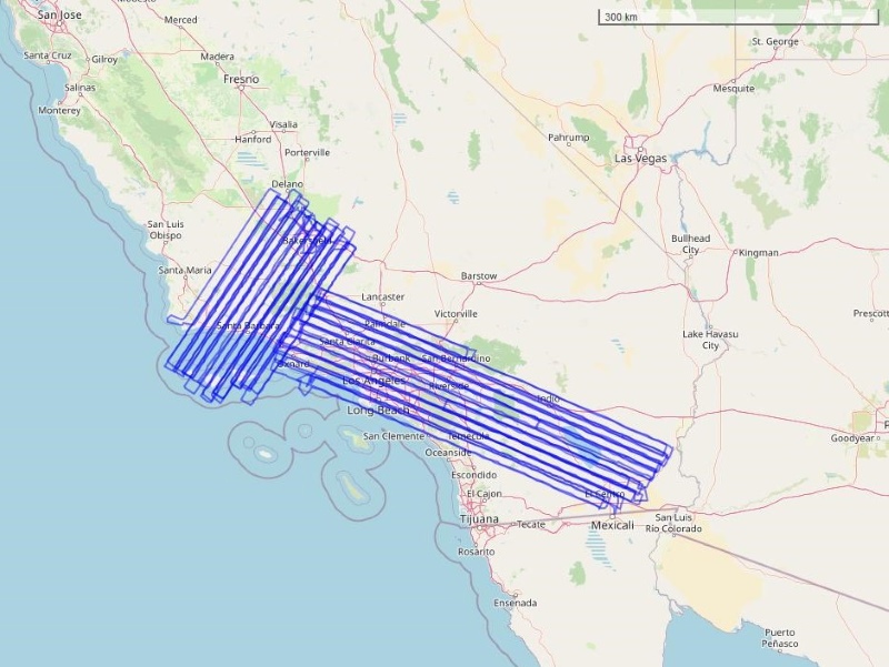
COMEX: AVIRIS-Classic Facility Instrument Associated Flights and Information, 2014
National Aeronautics and Space Administration —
This dataset lists flight lines and provides data access links and contextual flight information for a subset of the AVIRIS-Classic Facility Instrument Collection... -
Federal
Arctic Boreal Annual Burned Area, Circumpolar Boreal Forest and Tundra, V2, 2002-2022
National Aeronautics and Space Administration —
This dataset provides annual cumulative end-of-season burned area in circumpolar boreal forests and tundra for the years 2002-2022. The data were generated using the... -
Federal
Global Fire Atlas with Characteristics of Individual Fires, 2003-2016
National Aeronautics and Space Administration —
The Global Fire Atlas is a global dataset that tracks the day-to-day dynamics of individual fires to determine the timing and location of ignitions, fire size,... -
Federal
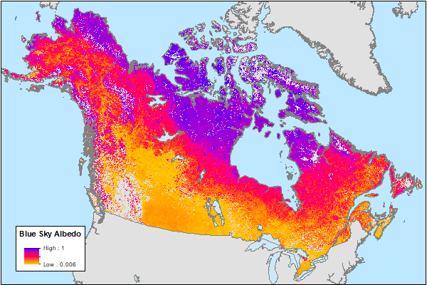
ABoVE: MODIS-Derived Daily Mean Blue Sky Albedo for Northern North America, 2000-2017
National Aeronautics and Space Administration —
This dataset contains MODIS-derived daily mean shortwave blue sky albedo for northern North America (i.e., Canada and Alaska) and a set of quality control flags for... -
Federal
Delta-X: AirSWOT Level 1B Interferogram Products in Radar Coordinates, 2021
National Aeronautics and Space Administration —
This dataset contains AirSWOT interferogram products collected during the 2021 Delta-X Campaign over the Atchafalaya and Terrebonne Basins of the Mississippi River... -
Federal
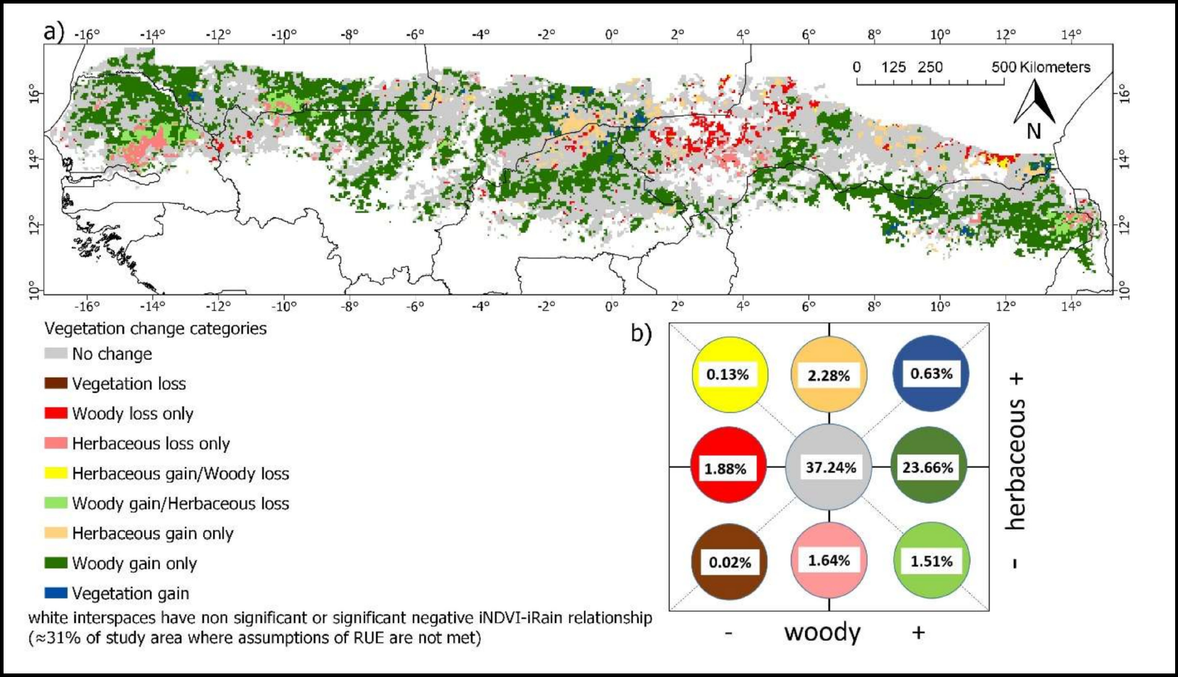
Woody and Herbaceous Vegetation Change across the Savannas of West Africa, 1982-2013
National Aeronautics and Space Administration —
The WAVeTrends dataset is a 0.05 degree (5.55 km) vegetation change product, spanning the West African Sudano-Sahel region. It provides pixel-wise information on... -
Federal
BOREAS RSS-14 GOES-8 Level-1a Visible, Infrared and Water Vapor Images
National Aeronautics and Space Administration —
The BOREAS RSS-14 team collected and processed several GOES-7 and GOES-8 image data sets that covered the BOREAS study region. The level-1a GOES-8 images were created... -
Federal
NPP Multi-Biome: Grassland, Boreal Forest, and Tropical Forest Sites, 1939-1996, R1
National Aeronautics and Space Administration —
This data set contains one data file (.csv format) that provides net primary productivity (NPP) estimates for 34 grasslands, 14 tropical forests, and 5 boreal forest...

Official websites use .gov
A
.gov website belongs to an official government
organization in the United States.
Secure .gov websites use HTTPS
A
lock (
) or https:// means you’ve safely connected to
the .gov website. Share sensitive information only on official,
secure websites.