
-
Federal
BOREAS RSS-18 Level 1B AVIRIS At-Sensor Radiance Imagery
National Aeronautics and Space Administration —
This dataset holds Level 1B (L1B) radiance data collected by the AVIRIS-Classic instrument near Prince Albert, Saskatchewan, Canada, on August 14, 1996. This imagery... -
Federal
L2 Daily Solar-Induced Fluorescence (SIF) from ERS-2 GOME, 1995-2003
National Aeronautics and Space Administration —
This dataset provides Level 2 Solar-Induced Fluorescence (SIF) of Chlorophyll estimates derived from the Global Ozone Monitoring Experiment (GOME) instrument on the... -
Federal
ABoVE: Passive Microwave-derived Annual Snowpack Main Melt Onset Date Maps, 1988-2023
National Aeronautics and Space Administration —
This dataset provides the annual date of snowpack seasonal beginning melt (i.e., main melt onset date, MMOD) across northwest Canada, Alaska, US, and parts of far... -
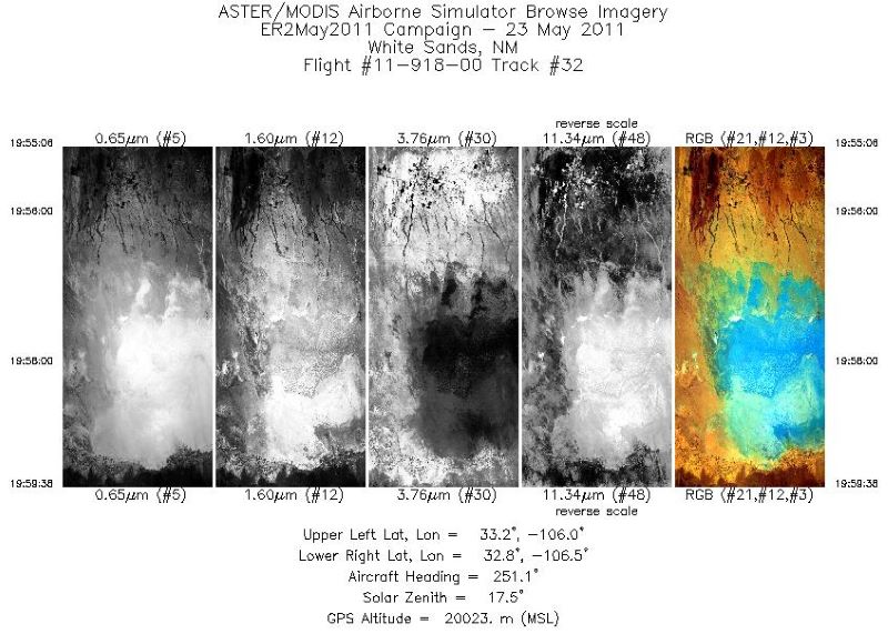
Federal
MASTER: California Fires, California, November 2007
National Aeronautics and Space Administration —
This dataset includes Level 1B (L1B) data products from the MODIS/ASTER Airborne Simulator (MASTER) instrument. The spectral data were collected during six flights... -
Federal
MASTER: HyspIRI Airborne Campaign, Hawaii, 2018
National Aeronautics and Space Administration —
This dataset includes Level 1B (L1B) and Level 2 (L2) data products from the MODIS/ASTER Airborne Simulator (MASTER) instrument. The spectral data were collected as... -
Federal
CMS: Forest Inventory and Biophysical Measurements, Para, Brazil, 2012-2014
National Aeronautics and Space Administration —
This data set provides measurements for diameter at breast height (DBH), commercial tree height, and total tree height for forest inventories taken at the Fazenda... -
Federal
GEDI L4C Footprint Level Waveform Structural Complexity Index, Version 2
National Aeronautics and Space Administration —
This dataset contains Global Ecosystem Dynamics Investigation (GEDI) Level 4C (L4C) Version 2 predictions of the Waveform Structural Complexity Index (WSCI) and... -
Federal
Hourly Soil Moisture Logger Data, Alberta and Alaska, 2017-2021
National Aeronautics and Space Administration —
This dataset includes hourly in-situ soil moisture measurements from data loggers in predominantly organic soils (very low bulk density) at two locations: 1) along... -
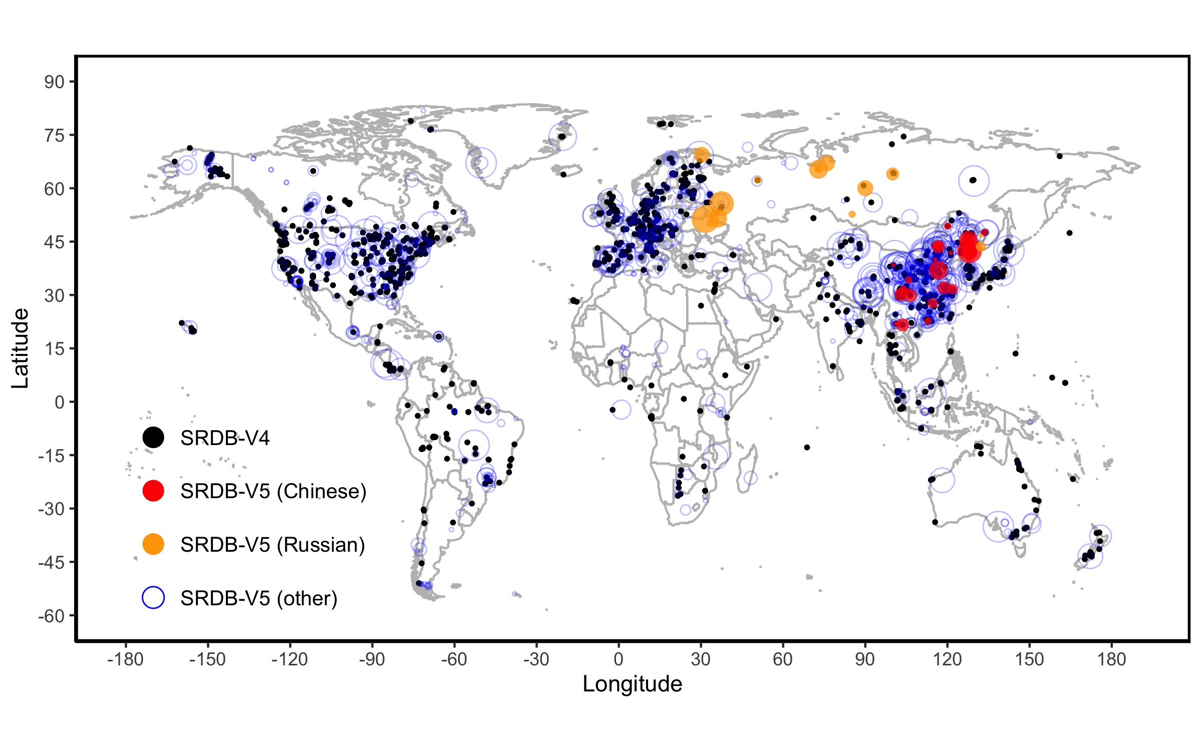
Federal
A Global Database of Soil Respiration Data, Version 5.0
National Aeronautics and Space Administration —
The Soil Respiration Database (SRDB) is a near-universal compendium of published soil respiration (Rs) data. The database encompasses published studies that report at... -
Federal
ABoVE: Passive Microwave-derived Annual Snowpack Main Melt Onset Date Maps, 1988-2018
National Aeronautics and Space Administration —
This dataset provides the annual date of snowpack seasonal beginning melt (i.e., main melt onset date, MMOD) across northwest Canada; Alaska, U.S.; and parts of far... -
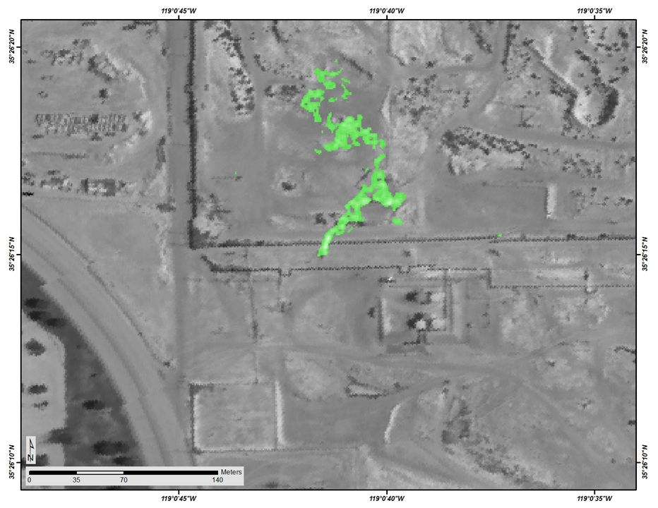
Federal
Longwave-infrared spectral imagery in support of COMEX, 2014
National Aeronautics and Space Administration —
This dataset provides calibrated at-sensor radiance, retrieved surface brightness temperature, and adaptive coherence estimator (ACE) detection imagery of methane,... -
Federal
Arctic Vegetation Plots at Atqasuk, Alaska, 1975, 2000, and 2010
National Aeronautics and Space Administration —
This data set provides vegetation species abundance data collected in 1975 from 60 sites on the Arctic Coastal Plain near Atqasuk, Alaska, as well as environmental... -
Federal
CMS: Global 0.5-deg Wetland Methane Emissions and Uncertainty (WetCHARTs v1.3.3)
National Aeronautics and Space Administration —
This dataset provides global monthly wetland methane (CH4) emissions estimates at 0.5 by 0.5-degree resolution for the period 2001-01-01 to 2022-08-31 that were... -
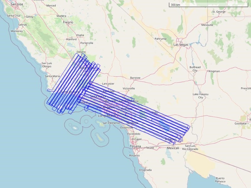
Federal
COMEX: AVIRIS-Classic Facility Instrument Associated Flights and Information, 2014
National Aeronautics and Space Administration —
This dataset lists flight lines and provides data access links and contextual flight information for a subset of the AVIRIS-Classic Facility Instrument Collection... -
Federal
Impacts of Wildfires on Boreal Forest Ecosystem Carbon Dynamics
National Aeronautics and Space Administration —
This dataset contains simulations of net primary production (NPP), heterotrophic respiration (RH), net ecosystem production (NEP), and soil temperature data in North... -
Federal
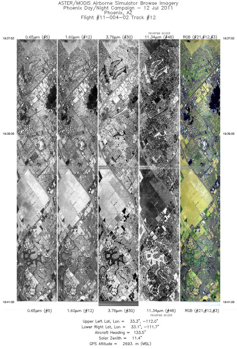
MASTER: Heat Island Airborne Study, Phoenix, Arizona, 2011
National Aeronautics and Space Administration —
This dataset includes Level 1B (L1B) data products from the MODIS/ASTER Airborne Simulator (MASTER) instrument. The spectral data were collected during five flights... -
Federal
MASTER: HyspIRI Airborne Campaign, California, Spring 2015
National Aeronautics and Space Administration —
This dataset includes Level 1B (L1B) and Level 2 (L2) data products from the MODIS/ASTER Airborne Simulator (MASTER) instrument. The spectral data were collected as... -
Federal
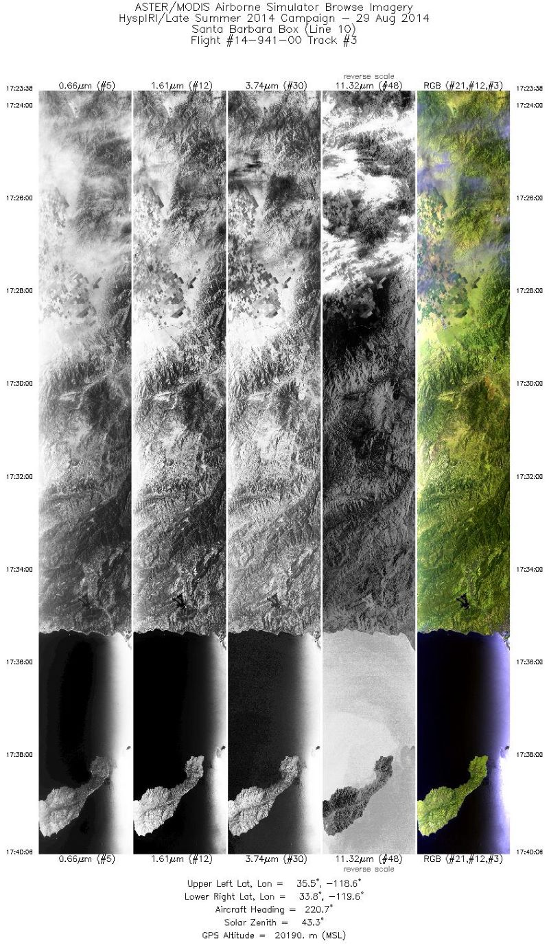
MASTER: HyspIRI Airborne Campaign, California, Summer 2014
National Aeronautics and Space Administration —
This dataset includes Level 1B (L1B) and Level 2 (L2) data products from the MODIS/ASTER Airborne Simulator (MASTER) instrument. The spectral data were collected as...

Official websites use .gov
A
.gov website belongs to an official government
organization in the United States.
Secure .gov websites use HTTPS
A
lock (
) or https:// means you’ve safely connected to
the .gov website. Share sensitive information only on official,
secure websites.