

14 datasets found for "苹果马甲包研发[567seo.com]"
-
Federal
Global Gridded Surfaces of Selected Soil Characteristics (IGBP-DIS)
National Aeronautics and Space Administration —
The Global Gridded Surfaces of Selected Soil Characteristics (IGBP-DIS) data set contains 7 data surfaces: soil-carbon density, total nitrogen density, field... -
Federal
VEMAP 2: U.S. Monthly Climate, 1895-1993, Version 2
National Aeronautics and Space Administration —
The Vegetation/Ecosystem Modeling and Analysis Project (VEMAP) Phase 2 has developed a data set of ~100-year gridded monthly and daily time series of climate for the... -
Federal
TransCom 3: Annual Mean CO2 Flux Estimates from Atmospheric Inversions (Level 1)
National Aeronautics and Space Administration —
The Atmospheric Tracer Transport Model Intercomparison Project (TransCom) was created to quantify and diagnose the uncertainty in inversion calculations of the global... -
Federal
SiB3 Modeled Global 1-degree Hourly Biosphere-Atmosphere Carbon Flux, 1998-2006
National Aeronautics and Space Administration —
The Simple Biosphere Model, Version 3 (SiB3) was used to produce a global data set of hourly carbon fluxes between the atmosphere and the terrestrial biosphere for... -
Federal
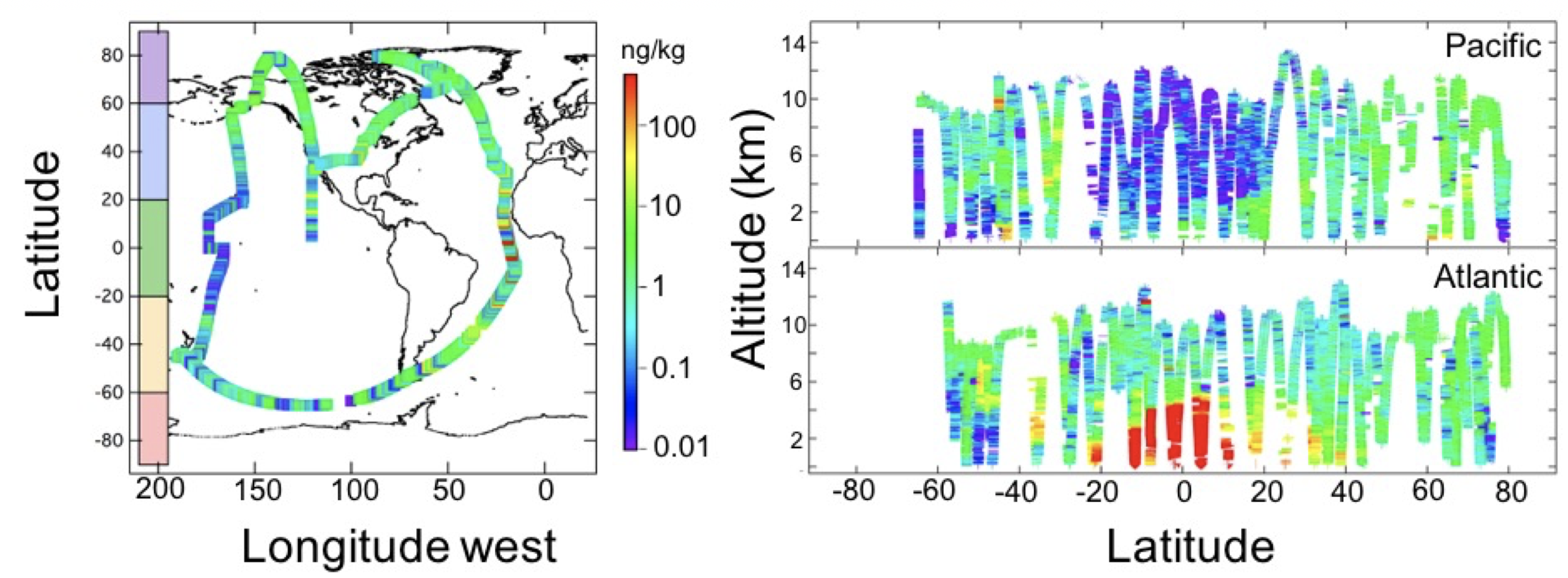
ATom: Black Carbon Mass Mixing Ratios from ATom-1 Flights
National Aeronautics and Space Administration —
This dataset provides black carbon (BC) mass mixing ratios (in units of ng BC / kg air) measured during NASA's Atmospheric Tomography (ATom)-1 flight campaign during... -
Federal
BOREAS RSS-02 Extracted Reflectance Factors Derived from ASAS Imagery
National Aeronautics and Space Administration —
Atmospherically-corrected bidirectional reflectance factor means for small homogeneous areas from several BOREAS sites were derived from multi-spectral, multi-angle... -
Federal
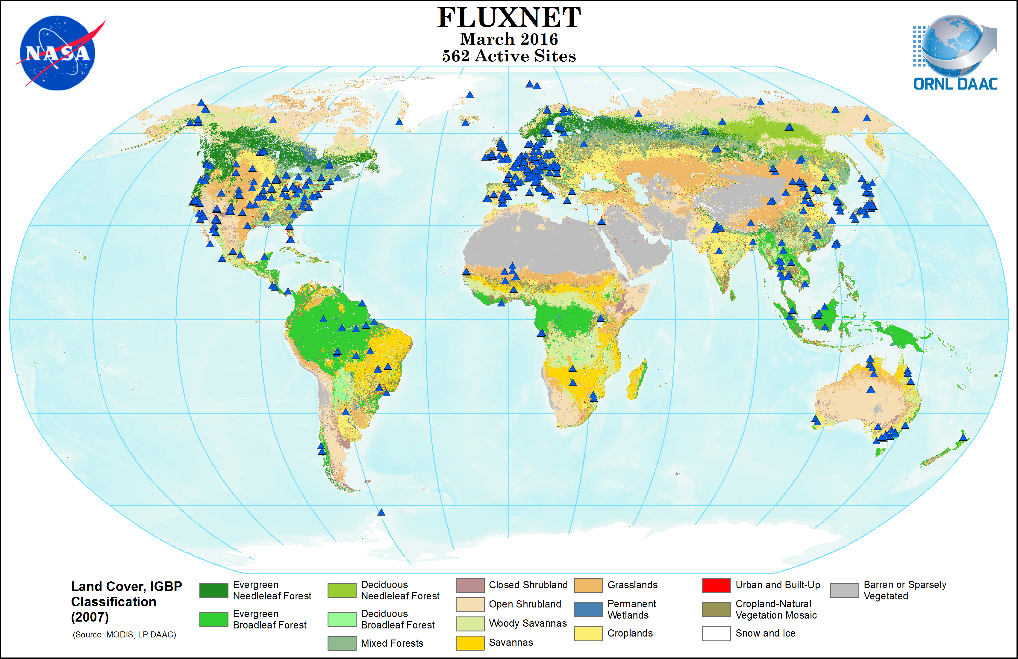
FLUXNET Research Network Site Characteristics, Investigators, and Bibliography, 2016
National Aeronautics and Space Administration —
FLUXNET is a global network of micrometeorological tower sites that use eddy covariance methods to measure the exchanges of carbon dioxide, water vapor, and energy... -
Federal
VEMAP 2: U.S. Monthly Climate Change Scenarios, Version 2
National Aeronautics and Space Administration —
The Vegetation/Ecosystem Modeling and Analysis Project (VEMAP) Phase 2 has developed a number of transient climate change scenarios based on coupled atmosphere-ocean... -
Federal
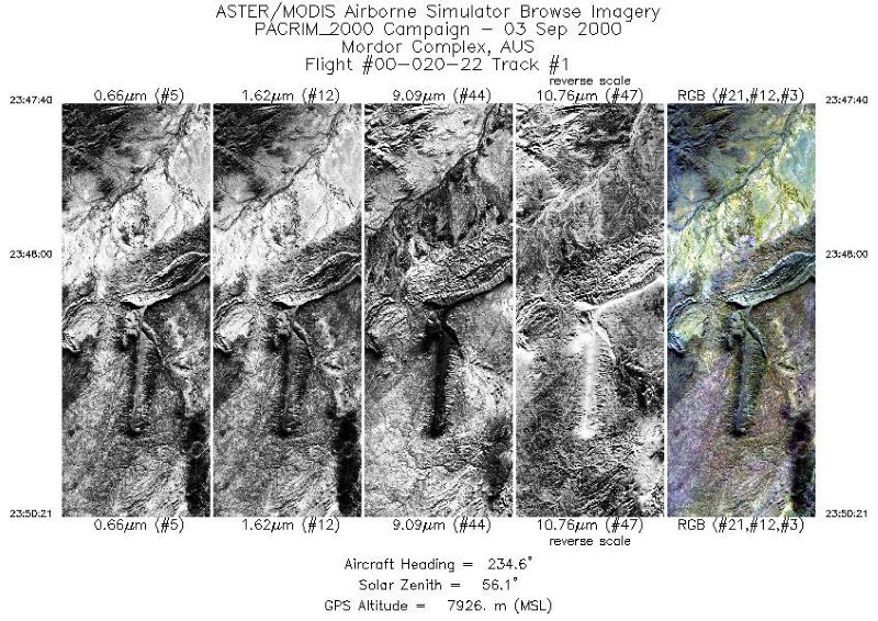
MASTER: Pacific Rim Campaign, July-October, 2000
National Aeronautics and Space Administration —
This dataset includes Level 1B (L1B) data products from the MODIS/ASTER Airborne Simulator (MASTER) instrument. The spectral data were collected during 46 flights... -
Federal
TransCom 3: Seasonal CO2 Flux Estimates from Atmospheric Inversions (Level 2)
National Aeronautics and Space Administration —
This data set provides model outputs and seasonal mean CO2 fluxes from the Atmospheric Carbon Cycle Inversion Intercomparison (TransCom 3), Level 2 inversion... -
Federal
Pre-Delta-X: AVIRIS-derived Total Suspended Solids Maps for MRD, LA, USA, 2015-2016
National Aeronautics and Space Administration —
This dataset includes total suspended solids (TSS) at the water surface across the Atchafalaya and Terrebonne Basins in Southern Louisiana, USA, within the... -
Federal
NPP Tropical Forest: Barro Colorado, Panama, 1969-1990, R1
National Aeronautics and Space Administration —
This data set contains three ASCII files (.txt format). One file provides net primary productivity (NPP) data for the moist lowland tropical forest on Barro Colorado... -
Federal
Conifer Needle Pigment Composition, Niwot Ridge, Colorado, USA, 2017-2018
National Aeronautics and Space Administration —
This dataset provides concentrations of pigments in pine and spruce needle tissues collected at the Niwot Ridge AmeriFlux Core site (US-NR1) near Nederland, Colorado,... -
Federal
Pre-Delta-X: L2 AVIRIS-NG Surface Spectral Reflectance across MRD, LA, USA, 2015-2016
National Aeronautics and Space Administration —
This Level 2 (L2) dataset provides surface spectral reflectance data acquired over the Atchafalaya and Terrebonne basins of the Mississippi River Delta (MRD) of...
14 datasets found for "苹果马甲包研发[567seo.com]"