
-
Federal
NACP North American Forest Dynamics Project: Forest Disturbance and Regrowth Data
National Aeronautics and Space Administration —
This data set provides the results of time-series analyses of Landsat imagery for 55 selected forested sites across the conterminous U.S.A. The output is a pair of... -
Federal
VEMAP 2: U.S. Daily Climate Change Scenarios
National Aeronautics and Space Administration —
The Vegetation/Ecosystem Modeling and Analysis Project (VEMAP) Phase 2 has developed a number of transient climate change scenarios based on coupled atmosphere-ocean... -
Federal
Global 1-km Gridded Thickness of Soil, Regolith, and Sedimentary Deposit Layers
National Aeronautics and Space Administration —
This data set provides high-resolution estimates of the thickness of the permeable layers above bedrock (soil, regolith, and sedimentary deposits) within a global... -
Federal
VEMAP 2: U.S. Annual Climate Change Scenarios
National Aeronautics and Space Administration —
The Vegetation/Ecosystem Modeling and Analysis Project (VEMAP) Phase 2 has developed a number of transient climate change scenarios based on coupled atmosphere-ocean... -
Federal
Amazon River Basin Precipitation, 1972-1992
National Aeronautics and Space Administration —
The Amazon River Basin precipitation grids were derived from data which was collected daily by the gauging network operated by the Divisao Nacional de Aguas e Energia... -
Federal
SE-590 Landscape Reflectances (OTTER)
National Aeronautics and Space Administration —
Bidirectional spectral reflectance factors of landscape elements (litter, scrubs and grasses, leaves) measured by the Spectron SE590 spectroradiometer. -
Federal
LBA-ECO CD-10 CO2 and H2O Eddy Flux Data at km 67 Tower Site, Tapajos National Forest
National Aeronautics and Space Administration —
This data set reports eddy flux measurements of CO2 and H2O exchange and associated meteorological measurements at the Para Western (Santarem) - km 67, Primary Forest... -
Federal
ISLSCP II Northern Hemisphere Monthly Snow Cover Extent
National Aeronautics and Space Administration —
This ISLSCP data set is derived from the National Snow and Ice Data Center (NSIDC) Northern Hemisphere EASE-Grid Weekly Snow Cover and Sea Ice Extent product which... -
Federal
SAFARI 2000 Aerosol Fatty Acid and Stable Isotope Data, Mongu, Dry Season 2000
National Aeronautics and Space Administration —
The Southern African Regional Science Initiative (SAFARI 2000) was conducted in part to investigate the impacts of the large-scale transport and deposition of... -
Federal
ABoVE: Lake Growing Season Green Surface Reflectance Trends, AK and Canada, 1984-2019
National Aeronautics and Space Administration —
This dataset provides an annual time series of Landsat green surface reflectance and the derived annual trend during the growing season (June and July) for 472,890... -
Federal
BOREAS TE-18 Landsat TM Maximum Likelihood Classification Image of the SSA
National Aeronautics and Space Administration —
A Landsat-5 TM image from 06-Aug-1990 was used to derive this classification. The objective of this classification is to provide the BOREAS investigators with a data... -
Federal
BOREAS TE-18 Landsat TM Physical Classification Image of the SSA
National Aeronautics and Space Administration —
The objective of this classification is to provide the BOREAS investigators with a data product that characterizes the land cover of the SSA. A Landsat-5 TM image... -
Federal
BOREAS HYD-03 Snow Water Equivalent: 1996
National Aeronautics and Space Administration —
The BOREAS HYD-03 team collected several data sets related to the hydrology of forested areas. This data set contains measurements of snow depth, snow density in 3-cm... -
Federal
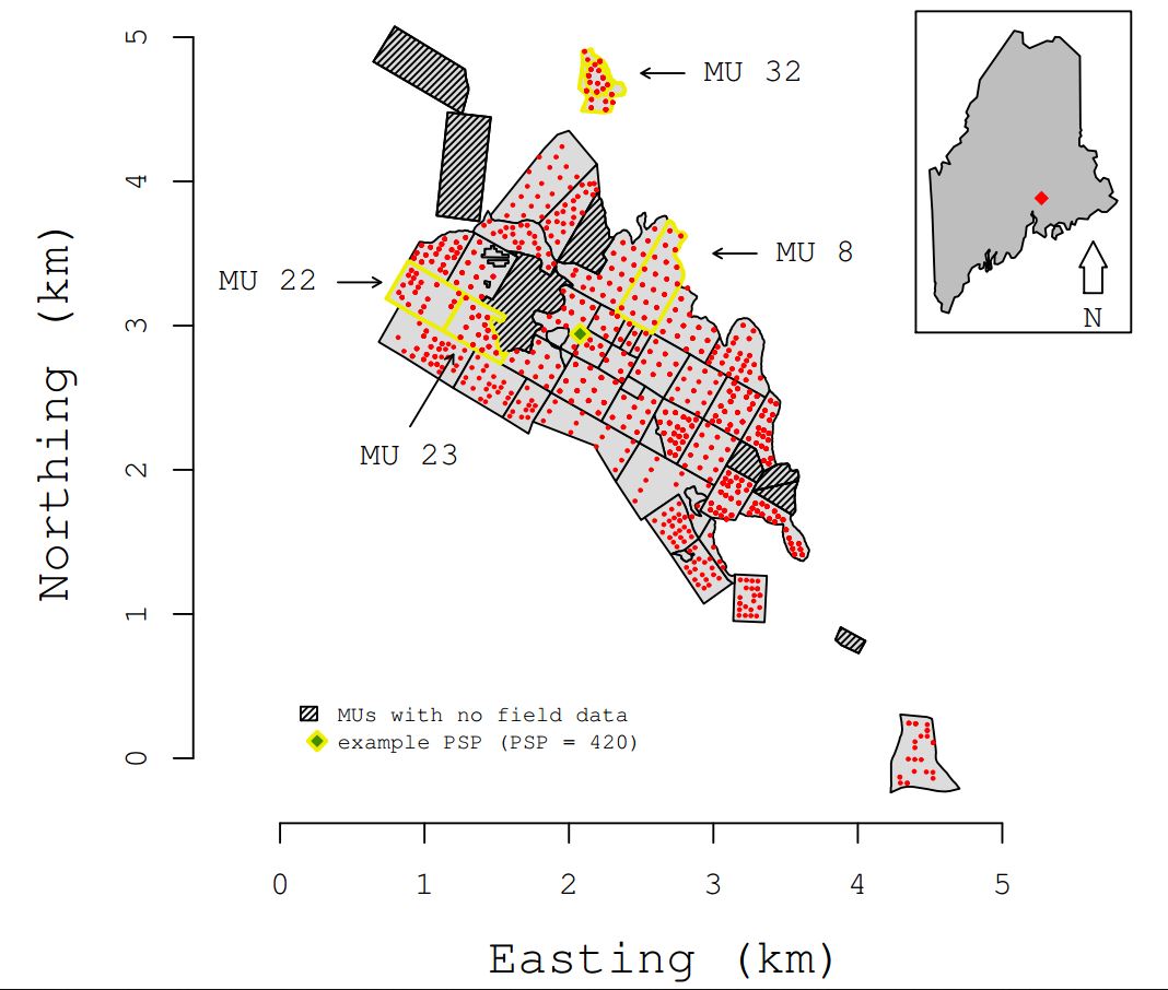
CMS: Aboveground Biomass from Penobscot Experimental Forest, Maine, 2012
National Aeronautics and Space Administration —
This data set includes estimates of aboveground biomass (AGB) in 2012 from the Penobscot Experimental Forest (PEF) in Bradley, Maine. The AGB was modeled using LiDAR... -
Federal
Global Annual Soil Respiration Data (Raich and Schlesinger 1992)
National Aeronautics and Space Administration —
This data set is a compilation of soil respiration rates (g C m-2 yr-1) from terrestrial and wetland ecosystems reported in the literature prior to 1992. These rates... -
Federal
ABoVE: Vegetation Composition across Fire History Gradients on the Y-K Delta, Alaska
National Aeronautics and Space Administration —
This dataset provides ecological field data that were collected during July 2017 and July 2018 from 43 plots spanning gradients of fire history in the upland tundra... -
Federal
Soil Matric Potential, Dielectric, and Physical Properties, Arctic Alaska, 2018
National Aeronautics and Space Administration —
This dataset provides lab-measured soil properties, including soil water matric potential, soil dielectric properties, soil electrical conductivity, corresponding... -
Federal
Northern and Mid-Latitude Soil Database, Version 1, R1
National Aeronautics and Space Administration —
The U.S. Department of Agriculture, Agriculture and Agri-Food Canada, the Russian Academy of Agricultural Sciences, the University of Copenhagen Institute of... -
Federal
NACP: Forest Carbon Stocks, Fluxes and Productivity Estimates, Western USA, 1979-2099
National Aeronautics and Space Administration —
This dataset contains annual estimates of carbon stocks, fluxes, and productivity over forested land in 11 states of the western USA (Arizona, California, Colorado,...

Official websites use .gov
A
.gov website belongs to an official government
organization in the United States.
Secure .gov websites use HTTPS
A
lock (
) or https:// means you’ve safely connected to
the .gov website. Share sensitive information only on official,
secure websites.