
-
Federal
Reflectance Reference Targets (OTTER)
National Aeronautics and Space Administration —
Spectral reflectance measurements of flat field targets as reference points representative of psuedo-invariant targets as measured by the Spectron SE590... -
Federal
BOREAS TE-18 Landsat TM Physical Classification Image of the SSA
National Aeronautics and Space Administration —
The objective of this classification is to provide the BOREAS investigators with a data product that characterizes the land cover of the SSA. A Landsat-5 TM image... -
Federal
LBA-ECO LC-03 Hypsography, Rivers, Roads, and DEM, Four Areas across Brazilian Amazon
National Aeronautics and Space Administration —
This data set provides four related spatial data products for four study areas across the Brazilian Amazon: Manaus, Amazonas; Tapajos National Forest, Para Western... -
Federal
LBA-ECO ND-02 Agricultural and Secondary Forest Soil Trace Gas Flux, Para: 2001-2004
National Aeronautics and Space Administration —
Fires set for slash-and-burn agriculture contribute to the current unsustainable accumulation of atmospheric greenhouse gases, and they also deplete the soil of... -
Federal
Soil Reflectance Data (FIFE)
National Aeronautics and Space Administration —
Soil reflectance properties are an important factor in determining landscape reflectance characteristics. No soil reflectance data were collected as part of the FIFE... -
Federal
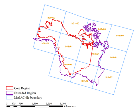
ABoVE: Angular-corrected MODIS MAIAC Reflectance across Alaska and Canada, 2000-2017
National Aeronautics and Space Administration —
This dataset provides angular corrections of MODIS Multi-Angle Implementation of Atmospheric Correction algorithm (MAIAC) surface reflectances across the ABoVE domain... -
Federal
BOREAS TGB-12 Soil Carbon and Flux Data of NSA-MSA in Raster Format
National Aeronautics and Space Administration —
The BOREAS TGB-12 team made measurements of soil carbon inventories, carbon concentration in soil gases, and rates of soil respiration at several sites. This data set... -
Federal
LBA-ECO CD-06 Carbon Cycling in Rivers in Amazonas and Acre, Brazil: 2005-2006
National Aeronautics and Space Administration —
This data set provides measured and calculated variables describing the carbon pools in river waters, CO2 respired from the water and total amount of CO2 evaded,... -
Federal
NACP Aboveground Biomass and Carbon Baseline Data, V.2 (NBCD 2000), U.S.A., 2000
National Aeronautics and Space Administration —
The NBCD 2000 (National Biomass and Carbon Dataset for the Year 2000) data set provides a high-resolution (30 m) map of year-2000 baseline estimates of basal area-... -
Federal
BOREAS TE-07 Sap Flow Data
National Aeronautics and Space Administration —
The BOREAS TE-07 team collected data sets in support of its efforts to characterize and interpret information on the sap flow of boreal vegetation. The heat pulse... -
Federal
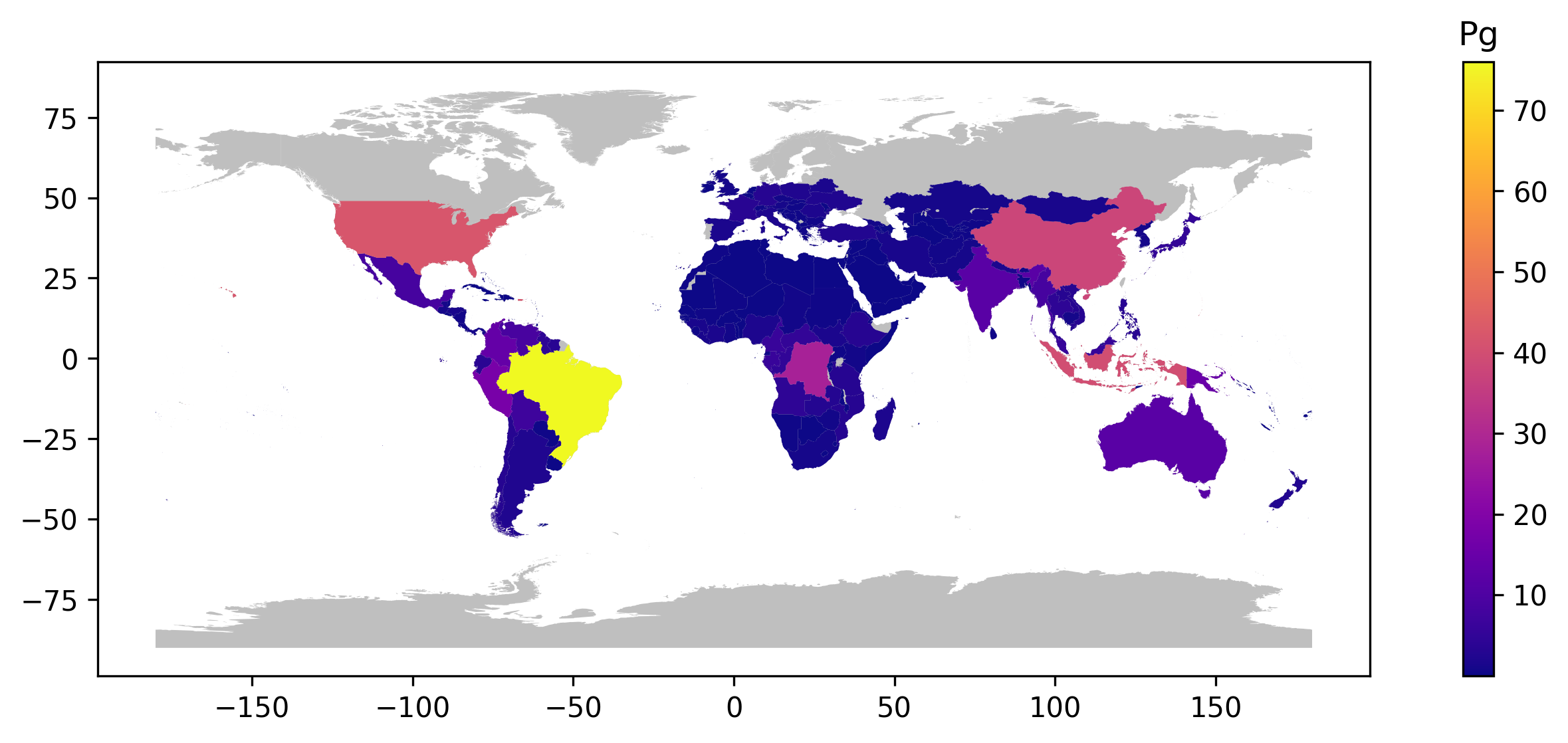
GEDI L4B Country-level Summaries of Aboveground Biomass
National Aeronautics and Space Administration —
This dataset provides country-level estimates of land surface mean aboveground biomass density (AGBD), total aboveground biomass (AGB) stocks, and the associated... -
Federal
BOREAS Elevation Contours over the NSA and SSA ARC/Info Generate Format
National Aeronautics and Space Administration —
This data set was prepared by BORIS staff by reformatting the original data into the ARC/INFO Generate format. The original data were received in SIF at a scale of... -
Federal
LBA-ECO LC-22 Land Cover from MODIS Vegetation Indices, Mato Grosso, Brazil
National Aeronautics and Space Administration —
This data set, LBA-ECO LC-22 Land Cover from MODIS Vegetation Indices, Mato Grosso, Brazil, provides land cover classifications for Mato Grosso, Brazil, for the years... -
Federal
LBA-ECO CD-06 CO2 Exchange in River Systems Across the Amazon Basin: 2004-2007
National Aeronautics and Space Administration —
This data set provides measurements of carbon dioxide flux rates (FCO2), gas transfer velocity (k), and partial pressures (pCO2) at 75 sites on rivers and streams of... -
Federal
Maps of Vegetation Types and Physiographic Features, Imnavait Creek, Alaska
National Aeronautics and Space Administration —
This dataset provides the spatial distribution of vegetation types, soil carbon, and physiographic features in the Imnavait Creek area, Alaska. Specific attributes... -
Federal
LBA-ECO TG-07 Trace Gas Fluxes, Undisturbed and Logged Sites, Para, Brazil: 2000-2002
National Aeronautics and Space Administration —
Selective logging is an extensive land use in the Brazilian Amazon region. We studied the soil-atmosphere fluxes of nitrous oxide (N2O), nitric oxide (NO), methane... -
Federal
Satellite Atmos. Correction Coef. (FIFE)
National Aeronautics and Space Administration —
The atmospheric effects on the transmitted and reflected solar radiation should be factored into the estimation of geophysical and biophysical parameters from... -
Federal
SAFARI 2000 ASTER and MODIS Fire Data Comparison, Dry Season 2001
National Aeronautics and Space Administration —
These data relate to a paper (Morisette et al., 2005) that describes the use of high spatial resolution ASTER data to determine the accuracy of the moderate... -
Federal
SAFARI 2000 Organic Soil Carbon and Nitrogen Data (Zinke et al.)
National Aeronautics and Space Administration —
The data set contains a subset of the Worldwide Organic Soil Carbon and Nitrogen (Zinke et al. 1986) data set for southern Africa. The data were obtained from soil...

Official websites use .gov
A
.gov website belongs to an official government
organization in the United States.
Secure .gov websites use HTTPS
A
lock (
) or https:// means you’ve safely connected to
the .gov website. Share sensitive information only on official,
secure websites.