
-
Federal
NACP Site: Terrestrial Biosphere Model Output Data in Original Format
National Aeronautics and Space Administration —
This data set contains the original model output data submissions from the 24 terrestrial biosphere models (TBM) that participated in the North American Carbon... -
Federal
LBA-ECO CD-10 CO2 and H2O Eddy Flux Data at km 67 Tower Site, Tapajos National Forest
National Aeronautics and Space Administration —
This data set reports eddy flux measurements of CO2 and H2O exchange and associated meteorological measurements at the Para Western (Santarem) - km 67, Primary Forest... -
Federal
LBA-ECO CD-06 Soil Classification Map, Ji-Parana River Basin, Rondonia, Brazil
National Aeronautics and Space Administration —
This data set provides a digital map of soil orders for the Ji-Parana River Basin, in the state of Rondonia, Brazil (Western Amazonia). Soil orders were manually... -
Federal
SAFARI 2000 Plant and Soil C and N Isotopes, Southern Africa, 1995-2000
National Aeronautics and Space Administration —
This data set contains measurements of the concentration and stable carbon (13C / 12C) and nitrogen (15N / 14N) isotope ratios of plant (leaves, roots and fungi) and... -
Federal
NACP Aboveground Biomass and Carbon Baseline Data, V.2 (NBCD 2000), U.S.A., 2000
National Aeronautics and Space Administration —
The NBCD 2000 (National Biomass and Carbon Dataset for the Year 2000) data set provides a high-resolution (30 m) map of year-2000 baseline estimates of basal area-... -
Federal
LBA-ECO LC-04 Satellite/Census-Based 5-Minute Land Use Data, Amazonia: 1980 and 1995
National Aeronautics and Space Administration —
Amazonia has been under considerable development pressure as croplands and pasture are established in areas formerly occupied by tropical forest and cerrado. Although... -
Federal
LBA-ECO LC-09 Land Cover Transitions Maps for Study Sites in Para, Brazil: 1970-2001
National Aeronautics and Space Administration —
This data set includes classified land cover transition maps at 30-m resolution derived from Landsat TM, MSS, ETM+ imagery and aerial photos of Altamira, Santarem,... -
Federal
LBA-ECO CD-10 Temperature Profiles at km 67 Tower Site, Tapajos National Forest
National Aeronautics and Space Administration —
This data set reports temperature measurements at the Para Western (Santarem) - km 67, Primary Forest Tower Site. This site is in the Tapajos National Forest located... -
Federal
LBA-ECO TG-03 Aeronet Aerosol Optical Thickness Measurements, Brazil: 1993-2005
National Aeronautics and Space Administration —
This data set includes aerosol optical thickness measurements from the CIMEL sunphotometer for 22 sites in Brazil during the period from 1993-2005. The AERONET... -
Federal
LBA-ECO TG-07 Soil Trace Gas Flux and Root Mortality, Tapajos National Forest
National Aeronautics and Space Administration —
We conducted an experiment on sand and clay tropical forest soils to test the short-term effect of root mortality on the soil-atmosphere flux of nitrous oxide, nitric... -
Federal
LBA-ECO TG-07 Soil CO2 Flux by Automated Chamber, Para, Brazil: 2001-2003
National Aeronautics and Space Administration —
The net ecosystem exchange of carbon dioxide was measured by eddy covariance methods for 3 years in two old-growth forest sites near Santarem, Brazil. Carbon was lost... -
Federal
SAFARI 2000 ASTER and MODIS Fire Data Comparison, Dry Season 2001
National Aeronautics and Space Administration —
These data relate to a paper (Morisette et al., 2005) that describes the use of high spatial resolution ASTER data to determine the accuracy of the moderate... -
Federal
Optical Thickness Data: Bruegge (FIFE)
National Aeronautics and Space Administration —
The NIPS and Reagan Sunphotometer Optical Thickness study compared various ground and image-based techniques used to characterize the atmosphere. These data are used... -
Federal
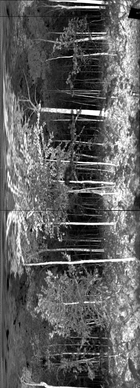
ECHIDNA LIDAR Campaigns: Forest Canopy Imagery and Field Data, U.S.A., 2007-2009
National Aeronautics and Space Administration —
This data set contains forest canopy scan data from the Echidna® Validation Instrument (EVI) and field measurements data from three campaigns conducted in the United... -
Federal
CARVE: Daily Thaw State of Boreal and Arctic Alaska from AMSR-E and SSM/I, 2003-2014
National Aeronautics and Space Administration —
This data set provides daily 10 km resolution maps of the Alaskan and Arctic Boreal land surface state as either frozen, melting, or thawed. These data are generated... -
Federal
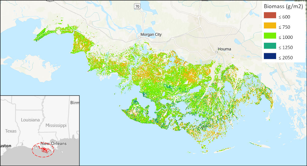
Aboveground Biomass High-Resolution Maps for Selected US Tidal Marshes, 2015
National Aeronautics and Space Administration —
This dataset provides maps of aboveground tidal marsh biomass (g/m2) at 30 m resolution for six estuarine regions of the conterminous United States: Cape Cod, MA;... -
Federal
BOREAS HYD-08 1994 Gravimetric Moss Moisture Data
National Aeronautics and Space Administration —
The BOREAS HYD-08 team made measurements of surface hydrological processes that were collected at the NSA OBS Tower Flux site in 1994 and at Joey Lake, Manitoba, to... -
Federal
ATom: GEOS-5 Derived Meteorological Conditions and Tagged Tracers Along Flight Tracks
National Aeronautics and Space Administration —
This dataset provides modeled meteorological conditions and tagged-CO tracer concentrations along ATom flight paths derived from the Goddard Earth Observing System... -
Federal
BOREAS Follow-On FLX-01 NSA-OBS Derived Data - NEE, GEE, and Respiration
National Aeronautics and Space Administration —
The BOREAS Follow-On FLX-01 team derived NEE, GEE, and Respiration using measured tower C02 flux measurements taken at the NSA-OBS site. The data provided contain...

Official websites use .gov
A
.gov website belongs to an official government
organization in the United States.
Secure .gov websites use HTTPS
A
lock (
) or https:// means you’ve safely connected to
the .gov website. Share sensitive information only on official,
secure websites.