

15 datasets found
-
Federal
SEDIMENT ANALYSIS NETWORK FOR DECISION SUPPORT (SANDS) MODIS GEOTIFF V1 NGDA recent views
National Aeronautics and Space Administration —
The Sediment Analysis Network for Decision Support (SANDS) MODIS GeoTIFF dataset consists of the set of GeoTIFF images provided to the Geological Survey of Alabama... -
Federal
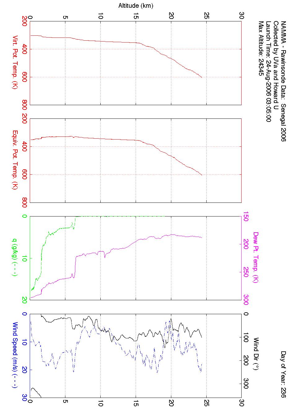
NAMMA SENEGAL RADIOSONDE AND TOWER FLUX DATA V1 recent views
National Aeronautics and Space Administration —
The NAMMA Senegal Radiosonde and Tower Flux data includes measurements of humidity, wind speed/direction and velocity. Additionally, the flux data includes... -
Federal
GPM GROUND VALIDATION SATELLITE SIMULATED ORBITS TWP-ICE V1 recent views
National Aeronautics and Space Administration —
The GPM Ground Validation Satellite Simulated Orbits TWP-ICE dataset is available in the Orbital database, which takes account for the atmospheric profiles, the... -
Federal
SEDIMENT ANALYSIS NETWORK FOR DECISION SUPPORT (SANDS) LANDSAT GEOTIFF V1 recent views
National Aeronautics and Space Administration —
The Sediment Analysis Network for Decision Support (SANDS) Landsat Geotiff dataset includes images for sediment redistribution after a hurricane on the coast of the... -
Federal
SEDIMENT ANALYSIS NETWORK FOR DECISION SUPPORT (SANDS) MODIS GEOLOGICAL SURVEY OF AL (GSA) ANALYSIS V1 NGDA recent views
National Aeronautics and Space Administration —
The Sediment Analysis Network for Decision Support (SANDS) MODIS Geological Survey of AL (GSA) Analysis dataset consists of geoTIFF images were analyzed for sediment... -
Federal
GPM Ground Validation Duke Soil Moisture IPHEx V1 recent views
National Aeronautics and Space Administration —
The GPM Ground Validation Duke Soil Moisture dataset consists of a collection of various data obtained during the Integrated Precipitation and Hydrology Experiment... -
Federal
GPM GROUND VALIDATION COMPOSITE SATELLITE OVERPASSES GCPEX V1 recent views
National Aeronautics and Space Administration —
The GPM Ground Validation Composite Satellite Overpasses GCPEx dataset provides satellite overpasses from the Special Sensor Microwave Imager/Sounder (SSMIS)... -
Federal
GPM Ground Validation Airborne Snow Observatory (ASO) OLYMPEX V1 recent views
National Aeronautics and Space Administration —
The GPM Ground Validation Airborne Snow Observatory (ASO) OLYMPEX dataset consists of snow depth, bare earth surface, land surface classification and a Red, Green,... -
Federal
SEDIMENT ANALYSIS NETWORK FOR DECISION SUPPORT (SANDS) LANDSAT GEOLOGICAL SURVEY OF AL (GSA) ANALYSIS V1 recent views
National Aeronautics and Space Administration —
The Sediment Analysis Network for Decision Support (SANDS) Landsat Geological Survey of AL (GSA) Analysis dataset analyzed changes in the coastal shoreline and... -
Federal
SEDIMENT ANALYSIS NETWORK FOR DECISION SUPPORT (SANDS) MODIS GULF SUBSETTED V1 NGDA recent views
National Aeronautics and Space Administration —
Sediment Analysis Network for Decision Support (SANDS) MODIS Gulf Subsetted dataset consists of daytime images for Terra and Aqua MODIS Reflectance bands 8-16,... -
Federal
GPM GROUND VALIDATION SATELLITE SIMULATED ORBITS C3VP V1 recent views
National Aeronautics and Space Administration —
The GPM Ground Validation Satellite Simulated Orbits C3VP dataset is available in the Orbital database, which takes account for the atmospheric profiles, the... -
Federal
GPM GROUND VALIDATION SATELLITE SIMULATED ORBITS LPVEX V1 recent views
National Aeronautics and Space Administration —
The GPM Ground Validation Satellite Simulated Orbits LPVEx dataset is available in the Orbital database, which takes account for the atmospheric profiles, the... -
Federal
GPM GROUND VALIDATION SATELLITE SIMULATED ORBITS MC3E V1 recent views
National Aeronautics and Space Administration —
The GPM Ground Validation Satellite Simulated Orbits MC3E dataset is available in the Orbital database , which takes account for the atmospheric profiles, the... -
Federal
GPM GROUND VALIDATION COMPOSITE SATELLITE OVERPASSES MC3E V1 recent views
National Aeronautics and Space Administration —
The GPM Ground Validation Composite Satellite Overpasses MC3E dataset provides satellite overpasses from the AQUA satellite during the Midlatitude Continental... -
Federal
GPM GROUND VALIDATION DC-8 CAMERA NADIR GCPEX V1 recent views
National Aeronautics and Space Administration —
The GPM Ground Validation DC-8 Camera Nadir GCPEx dataset contains geo-located, visible-wavelength imagery of the ground obtained from the nadir camera aboard the...
15 datasets found