
-
Federal
SASSIE Arctic Field Campaign Shipboard S-Band Radar Level 3 Data Fall 2022 recent views
National Aeronautics and Space Administration —
This dataset contains images from the S-BAND marine navigation radar collected during the 2022 Salinity and Stratification at the Sea Ice Edge (SASSIE) campaign.... -
Federal
ECCO Sea-Ice and Snow Concentration and Thickness - Daily Mean 0.5 Degree (Version 4 Release 4) recent views
National Aeronautics and Space Administration —
This dataset contains daily-averaged sea-ice and snow concentration and thickness interpolated to a regular 0.5-degree grid from the ECCO Version 4 revision 4 (V4r4)... -
Federal
ECCO Sea-Ice and Snow Concentration and Thickness - Monthly Mean llc90 Grid (Version 4 Release 4) recent views
National Aeronautics and Space Administration —
This dataset provides monthly-averaged sea-ice and snow concentration, thickness, and pressure loading on the native Lat-Lon-Cap 90 (LLC90) model grid from the ECCO... -
Federal
NSCAT Gridded Level 3 Enhanced Resolution Sigma-0 from BYU recent views
National Aeronautics and Space Administration —
This NASA Scatterometer (NSCAT) satellite Sigma-0 dataset is generated by the Scatterometer Climate Record Pathfinder (SCP) project at Brigham Young University (BYU)... -
Federal
SWOT Level 2 Radiometer Brightness Temperatures and Troposphere Interim Data Product Version 1.0 recent views
National Aeronautics and Space Administration —
The SWOT Level 2 Radiometer Brightness Temperatures and Troposphere Interim Geophysical Data Record (IGDR) Version 1.0 dataset produced by the Surface Water and Ocean... -
Federal
SWOT Level 2 Radiometer Brightness Temperatures and Troposphere Operational Data Product, Version 2.0 recent views
National Aeronautics and Space Administration —
The SWOT Level 2 Radiometer Brightness Temperatures and Troposphere Operational Geophysical Data Record (OGDR) Version 1.0 dataset produced by the Surface Water and... -
Federal
SWOT Level 2 Radiometer Brightness Temperatures and Troposphere Operational Data Product Version 1.0 recent views
National Aeronautics and Space Administration —
The SWOT Level 2 Radiometer Brightness Temperatures and Troposphere Operational Geophysical Data Record (OGDR) Version 1.0 dataset produced by the Surface Water and... -
Federal
ECCO Sea-Ice and Snow Horizontal Volume Fluxes - Monthly Mean llc90 Grid (Version 4 Release 4) recent views
National Aeronautics and Space Administration —
This dataset provides monthly-averaged sea-ice and snow horizontal volume fluxes on the native Lat-Lon-Cap 90 (LLC90) model grid from the ECCO Version 4 Release 4... -
Federal
ECCO Sea-Ice and Snow Horizontal Volume Fluxes - Daily Mean llc90 Grid (Version 4 Release 4) recent views
National Aeronautics and Space Administration —
This dataset provides daily-averaged sea-ice and snow horizontal volume fluxes on the native Lat-Lon-Cap 90 (LLC90) model grid from the ECCO Version 4 Release 4... -
Federal
ECCO Sea-Ice Velocity - Snapshot llc90 Grid (Version 4 Release 4) recent views
National Aeronautics and Space Administration —
This dataset provides instantaneous sea-ice velocity on the native Lat-Lon-Cap 90 (LLC90) model grid from the ECCO Version 4 Release 4 (V4r4) ocean and sea-ice state... -
Federal
SEASAT SCATTEROMETER BINNED 50KM SIGMA-0 DATA (Wentz) recent views
National Aeronautics and Space Administration —
Contains Seasat-A Scatterometer (SASS) Sigma-0 measurements for the entire Seasat mission, from July 1978 until October 1978, produced by Frank Wentz at Remote... -
Federal
ECCO Sea-Ice Velocity - Daily Mean 0.5 Degree (Version 4 Release 4) recent views
National Aeronautics and Space Administration —
This dataset contains daily-averaged sea-ice velocity interpolated to a regular 0.5-degree grid from the ECCO Version 4 revision 4 (V4r4) ocean and sea-ice state... -
Federal
ECCO Sea-Ice and Snow Concentration and Thickness - Monthly Mean 0.5 Degree (Version 4 Release 4) recent views
National Aeronautics and Space Administration —
This dataset contains monthly-averaged sea-ice and snow concentration and thickness interpolated to a regular 0.5-degree grid from the ECCO Version 4 revision 4... -
Federal
ECCO Sea-Ice and Snow Concentration and Thickness - Snapshot llc90 Grid (Version 4 Release 4) recent views
National Aeronautics and Space Administration —
This dataset provides instantaneous sea-ice and snow concentration, thickness, and pressure loading on the native Lat-Lon-Cap 90 (LLC90) model grid from the ECCO... -
Federal
SASSIE Arctic Field Campaign Shipboard S-Band Radar Level 4 Data Fall 2022 recent views
National Aeronautics and Space Administration —
This dataset contains images from the S-BAND marine navigation radar collected during the 2022 Salinity and Stratification at the Sea Ice Edge (SASSIE) campaign.... -
Federal
ECCO Sea-Ice Velocity - Monthly Mean 0.5 Degree (Version 4 Release 4) recent views
National Aeronautics and Space Administration —
This dataset contains monthly-averaged sea-ice velocity interpolated to a regular 0.5-degree grid from the ECCO Version 4 revision 4 (V4r4) ocean and sea-ice state... -
Federal
SWOT Level 2 Radiometer Brightness Temperatures and Troposphere Interim Data Product, Version 2.0 recent views
National Aeronautics and Space Administration —
The SWOT Level 2 Radiometer Brightness Temperatures and Troposphere Interim Geophysical Data Record (IGDR) Version 1.0 dataset produced by the Surface Water and Ocean... -
Federal
ECCO Sea-Ice and Snow Concentration and Thickness - Daily Mean llc90 Grid (Version 4 Release 4) recent views
National Aeronautics and Space Administration —
This dataset provides daily-averaged sea-ice and snow concentration, thickness, and pressure loading on the native Lat-Lon-Cap 90 (LLC90) model grid from the ECCO... -
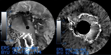
Federal
ERS-1 Gridded Level 3 Enhanced Resolution Sigma-0 from BYU recent views
National Aeronautics and Space Administration —
This European Remote Sensing (ERS) Sigma-0 dataset is generated by the Scatterometer Climate Record Pathfinder (SCP) project at Brigham Young University (BYU) and is... -
Federal
NSCAT High-Resolution MGDR, Sigma-0 and Ocean Wind Vectors (Dunbar) recent views
National Aeronautics and Space Administration —
The NASA Scatterometer (NSCAT) Level 2.5 high-resolution merged ocean wind vectors and sigma-0 in 25 km wind vector cell (WVC) swaths contain daily data from...

Official websites use .gov
A
.gov website belongs to an official government
organization in the United States.
Secure .gov websites use HTTPS
A
lock (
) or https:// means you’ve safely connected to
the .gov website. Share sensitive information only on official,
secure websites.