
-
Federal
Ocean Surface Current Analyses Real-time (OSCAR) Surface Currents - Final 0.25 Degree (Version 2.0) recent views
National Aeronautics and Space Administration —
Ocean Surface Current Analyses Real-time (OSCAR) is a global surface current database and NASA funded research project. OSCAR ocean mixed layer velocities are... -
Federal
SWOT Level 2 Lake Single-Pass Vector Data Product, Version 2.0 recent views
National Aeronautics and Space Administration —
The SWOT Level 2 Lake Single-Pass Vector Data Product from the Surface Water Ocean Topography (SWOT) mission provides water surface elevation, area, storage change... -
Federal
SASSIE Arctic Field Campaign Shipboard S-Band Radar Level 3 Data Fall 2022 recent views
National Aeronautics and Space Administration —
This dataset contains images from the S-BAND marine navigation radar collected during the 2022 Salinity and Stratification at the Sea Ice Edge (SASSIE) campaign.... -
Federal
SWOT Level 2 River Single-Pass Vector Data Product, Version 1.1 recent views
National Aeronautics and Space Administration —
Shapefiles of river reaches (approximately 10 km long) and nodes (approximately 200 m spacing) identified in prior river database. Reach attributes include water... -
Federal
CYGNSS Level 2 Science Data Record Version 3.1 recent views
National Aeronautics and Space Administration —
This dataset contains the Version 3.1 CYGNSS Level 2 Science Data Record which provides the time-tagged and geolocated average wind speed (m/s) and mean square slope... -
Federal
CYGNSS Level 1 Raw Intermediate Frequency Data Record recent views
National Aeronautics and Space Administration —
This Level 1 (L1) dataset contains the Raw Intermediate Frequency (IF) sensor data from the Delay Doppler Mapping Instrument aboard the CYGNSS satellite... -
Federal
ECCO Ocean and Sea-Ice Surface Heat Fluxes - Monthly Mean llc90 Grid (Version 4 Release 4) recent views
National Aeronautics and Space Administration —
This dataset provides monthly-averaged ocean and sea-ice surface heat fluxes on the native Lat-Lon-Cap 90 (LLC90) model grid from the ECCO Version 4 Release 4 (V4r4)... -
Federal
MODIS Aqua Level 3 SST Thermal IR Monthly 4km Daytime V2019.0 NGDA recent views
National Aeronautics and Space Administration —
Day and night spatially gridded (L3) global NASA skin sea surface temperature (SST) products from the Moderate-resolution Imaging Spectroradiometer (MODIS) onboard... -
Federal
SWOT Level 2 Water Mask Pixel Cloud Auxiliary Data Product, Version 1.1 recent views
National Aeronautics and Space Administration —
Auxiliary information for pixel cloud product indicating to which water bodies the pixels are assigned in river and lake products. Also includes height-constrained... -
Federal
ECCO Gent-McWilliams Ocean Bolus Velocity - Daily Mean llc90 Grid (Version 4 Release 4) recent views
National Aeronautics and Space Administration —
This dataset provides daily-averaged Gent-McWilliams ocean bolus velocity on the native Lat-Lon-Cap 90 (LLC90) model grid from the ECCO Version 4 Release 4 (V4r4)... -
Federal
GHRSST NOAA/STAR GOES-17 ABI L3C America Region SST v2.71 dataset in GDS2 recent views
National Aeronautics and Space Administration —
The ACSPO G17/ABI L3C (Level 3 Collated) product is a gridded version of the ACSPO G17/ABI L2P product available at... -
Federal
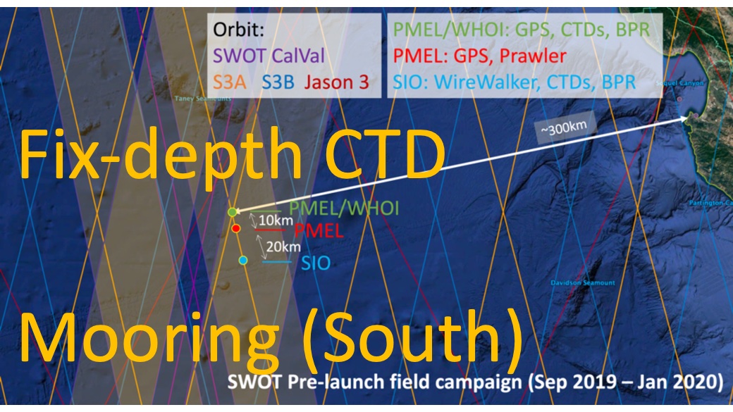
SWOT 2019-2020 Prelaunch Oceanography Field Campaign SIO Moored Fixed-Depth CTDs recent views
National Aeronautics and Space Administration —
This dataset provides the conductivity, temperature and depth (CTD) measurements from the fixed-depth CTD sensors mounted on a full-depth mooring deployed by the SWOT... -
Federal
SPURS-2 Passive Accoustic Listener (PAL) data from ARGO float deployments during the E. Tropical Pacific field campaign recent views
National Aeronautics and Space Administration —
The SPURS (Salinity Processes in the Upper Ocean Regional Study) project is a NASA-funded oceanographic process study and associated field program that aim to... -
Federal
GHRSST NOAA/STAR Metop-A AVHRR FRAC ACSPO v2.80 1km L2P Dataset (GDS v2) recent views
National Aeronautics and Space Administration —
The MetOp First Generation (FG) is a European multi-satellite program jointly established by ESA and EUMETSAT, comprising three satellites, MetOp-A, -B and -C. The... -
Federal
ECCO Ocean Velocity - Monthly Mean 0.5 Degree (Version 4 Release 4) recent views
National Aeronautics and Space Administration —
This dataset contains monthly-averaged ocean velocity interpolated to a regular 0.5-degree grid from the ECCO Version 4 revision 4 (V4r4) ocean and sea-ice state... -
Federal
ECCO Gent-McWilliams Ocean Bolus Velocity - Monthly Mean 0.5 Degree (Version 4 Release 4) recent views
National Aeronautics and Space Administration —
This dataset contains monthly-averaged Gent-McWilliams ocean bolus velocity interpolated to a regular 0.5-degree grid from the ECCO Version 4 revision 4 (V4r4) ocean... -
Federal
ECCO Sea-Ice Salt Plume Fluxes - Monthly Mean llc90 Grid (Version 4 Release 4) recent views
National Aeronautics and Space Administration —
This dataset provides monthly-averaged sea-ice salt plume fluxes on the native Lat-Lon-Cap 90 (LLC90) model grid from the ECCO Version 4 Release 4 (V4r4) ocean and... -
Federal
Aquarius Official Release Level 3 Sea Surface Salinity Standard Mapped Image Descending Daily Data V5.0 recent views
National Aeronautics and Space Administration —
Aquarius Level 3 sea surface salinity (SSS) standard mapped image data contains gridded 1 degree spatial resolution SSS averaged over daily, 7 day, monthly, and... -
Federal
UC Berkeley CYGNSS Level 3 Monthly RWAWC Watermask Version 3.1 recent views
National Aeronautics and Space Administration —
The CYGNSS Level 3 UC Berkeley Watermask Record Version 3.1 was developed by CYGNSS investigators in the Department of Civil and Environmental Engineering at the... -
Federal
Monthly gridded Global Land Data Assimilation System (GLDAS) from Noah-v3.3 land hydrology model for GRACE and GRACE-FO over nominal months recent views
National Aeronautics and Space Administration —
The total land water storage anomalies are aggregated from the Global Land Data Assimilation System (GLDAS) NOAH model. GLDAS outputs land water content by using...

Official websites use .gov
A
.gov website belongs to an official government
organization in the United States.
Secure .gov websites use HTTPS
A
lock (
) or https:// means you’ve safely connected to
the .gov website. Share sensitive information only on official,
secure websites.