

11 datasets found for "Wind Direction"
-
Federal
Saildrone Baja field campaign surface and ADCP measurements
National Aeronautics and Space Administration —
Saildrone is a wind and solar powered unmanned surface vehicle (USV) capable of long distance deployments lasting up to 12 months and providing high quality, near... -
Federal
NSCAT Level 2 Ocean Wind Vector Ambiguity Removal Overlay (Hoffman, AER)
National Aeronautics and Space Administration —
This dataset contains the NASA Scatterometer (NSCAT) Level 2 ocean wind vector ambiguity overlay files for the NSCAT MGDR version 2 dataset, referenced for 25 km wind... -
Federal
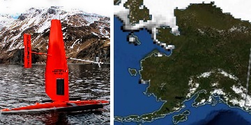
Saildrone 2021 Arctic field campaign for the Multi-Sensor Improved SST (MISST) project
National Aeronautics and Space Administration —
The Saildrone Arctic 2021 dataset presents a unique collection of high-quality, near real-time, multivariate surface ocean, and atmospheric observations obtained... -
Federal
SASSIE Arctic Field Campaign Jet Surface Salinity Profiler Data Fall 2022 Version 1
National Aeronautics and Space Administration —
The Salinity and Stratification at the Sea Ice Edge (SASSIE) project is a NASA experiment that aims to understand how salinity anomalies in the upper ocean generated... -
Federal
Jason-1 SGDR version E NetCDF
National Aeronautics and Space Administration —
The Sensory Geophysical Data Record (SGDR) files contain full accuracy altimeter data, with a high precision orbit (accuracy ~1.5 cm). The instruments on Jason-1 make... -
Federal
Jason-1 SGDR version E NetCDF Geodetic
National Aeronautics and Space Administration —
The Sensory Geophysical Data Record (SGDR) files from the Geodetic Mission contain full accuracy altimeter data, with a high precision orbit. The instruments on... -
Federal
Jason-1 GDR version E NetCDF Geodetic
National Aeronautics and Space Administration —
The Jason-1 Geophysical Data Records (GDR) Geodetic Mission contain full accuracy altimeter data, with a high precision orbit, provided approximately 35 days after... -
Federal
Jason-1 GDR SSHA version E NetCDF Geodetic
National Aeronautics and Space Administration —
These Sea Surface Height Anomalies (SSHA) are derived from the Jason-1 Geophysical Data Record (GDR) Geodetic Mission. Jason-1 is an altimetric mission whose... -
Federal
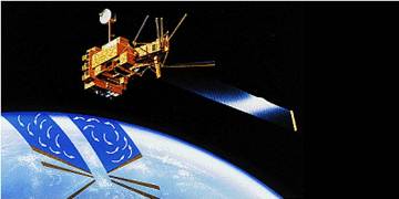
NSCAT Level 2 Ocean Wind Vector Geophysical Data Record
National Aeronautics and Space Administration —
The NASA Scatterometer (NSCAT) Level 2 ocean wind vectors in 50 km wind vector cell (WVC) swaths contain daily data from ascending and descending passes. Wind vectors... -
Federal
NSCAT High-Resolution MGDR, Sigma-0 and Ocean Wind Vectors (Dunbar)
National Aeronautics and Space Administration —
The NASA Scatterometer (NSCAT) Level 2.5 high-resolution merged ocean wind vectors and sigma-0 in 25 km wind vector cell (WVC) swaths contain daily data from... -
Federal
NSCAT High Resolution R-MGDR, Selected Ocean Wind Vectors (JPL)
National Aeronautics and Space Administration —
The NASA Scatterometer (NSCAT) Level 2.5 high-resolution reduced MGDR contains only wind vector data (sigma-0 is excluded) in 25 km wind vector cell (WVC) swaths...
11 datasets found for "Wind Direction"