
-
Federal
Aquarius Official Release Level 3 Sea Surface Salinity Standard Mapped Image Descending Daily Data V5.0 recent views
National Aeronautics and Space Administration —
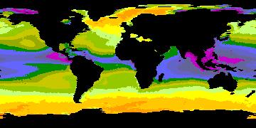
Aquarius Level 3 sea surface salinity (SSS) standard mapped image data contains gridded 1 degree spatial resolution SSS averaged over daily, 7 day, monthly, and... -
Federal
Aquarius Official Release Level 3 Sea Surface Spiciness Standard Mapped Image Ascending 28-Day Running Mean Data V5.0 recent views
National Aeronautics and Space Administration —
Aquarius Level 3 sea surface salinity spiciness standard mapped image data contains gridded 1 degree spatial resolution spice data averaged over daily, 7 day,... -
Federal
Aquarius Official Release Level 3 Sea Surface Salinity Standard Mapped Image Seasonal Data V5.0 recent views
National Aeronautics and Space Administration —
Aquarius Level 3 sea surface salinity (SSS) standard mapped image data contains gridded 1 degree spatial resolution SSS averaged over daily, 7 day, monthly, and... -
Federal
Aquarius Official Release Level 3 Wind Speed Standard Mapped Image Descending Mission Cumulative Data V5.0 recent views
National Aeronautics and Space Administration —
Aquarius Level 3 ocean surface wind speed standard mapped image data contains gridded 1 degree spatial resolution wind speed data averaged over daily, 7 day, monthly,... -
Federal
Aquarius Official Release Level 3 Sea Surface Density Standard Mapped Image Descending Daily Data V5.0 recent views
National Aeronautics and Space Administration —
Aquarius Level 3 sea surface density standard mapped image data contains gridded 1 degree spatial resolution density data averaged over daily, 7 day, monthly, and... -
Federal
Aquarius Official Release Level 3 Rain-flagged Sea Surface Salinity Standard Mapped Image Seasonal Data V5.0 recent views
National Aeronautics and Space Administration —
Aquarius Level 3 sea surface salinity (SSS) rain-flagged standard mapped image data contains gridded 1 degree spatial resolution SSS averaged over daily, 7 day,... -
Federal
Aquarius Official Release Level 3 Sea Surface Density Standard Mapped Image Ascending Daily Data V5.0 recent views
National Aeronautics and Space Administration —
Aquarius Level 3 sea surface density standard mapped image data contains gridded 1 degree spatial resolution density data averaged over daily, 7 day, monthly, and... -
Federal
Aquarius Official Release Level 3 Sea Surface Salinity Standard Mapped Image Daily Data V5.0 recent views
National Aeronautics and Space Administration —
Aquarius Level 3 sea surface salinity (SSS) standard mapped image data contains gridded 1 degree spatial resolution SSS averaged over daily, 7 day, monthly, and... -
Federal
Aquarius Official Release Level 3 Sea Surface Density Standard Mapped Image Mission Cumulative Data V5.0 recent views
National Aeronautics and Space Administration —
Aquarius Level 3 sea surface density standard mapped image data contains gridded 1 degree spatial resolution derived density averaged over daily, 7 day, monthly, and... -
Federal
Aquarius Official Release Level 3 Sea Surface Density Standard Mapped Image Annual Data V5.0 recent views
National Aeronautics and Space Administration —
Aquarius Level 3 sea surface density standard mapped image data contains gridded 1 degree spatial resolution SSS averaged over daily, 7 day, monthly, and seasonal... -
Federal
Aquarius Official Release Level 3 Wind Speed Standard Mapped Image Seasonal Data V5.0 recent views
National Aeronautics and Space Administration —
Aquarius Level 3 ocean surface wind speed standard mapped image data contains gridded 1 degree spatial resolution wind speed data averaged over daily, 7 day, monthly,... -
Federal
Aquarius Official Release Level 3 Sea Surface Spiciness Standard Mapped Image Descending Seasonal Data V5.0 recent views
National Aeronautics and Space Administration —
Aquarius Level 3 sea surface spiciness standard mapped image data contains gridded 1 degree spatial resolution spice data averaged over daily, 7 day, monthly, and... -
Federal
Aquarius Official Release Level 3 Rain-flagged Sea Surface Salinity Standard Mapped Image Ascending 7-Day Data V5.0 recent views
National Aeronautics and Space Administration —
Aquarius Level 3 sea surface salinity (SSS) rain-flagged standard mapped image data contains gridded 1 degree spatial resolution SSS averaged over daily, 7 day,... -
Federal
Aquarius Official Release Level 3 Sea Surface Salinity Standard Mapped Image Monthly Climatology Data V5.0 recent views
National Aeronautics and Space Administration —
Aquarius Level 3 sea surface salinity (SSS) standard mapped image data contains gridded 1 degree spatial resolution SSS averaged over daily, 7 day, monthly, and... -
Federal
Aquarius Official Release Level 3 Sea Surface Spiciness Standard Mapped Image Seasonal Data V5.0 recent views
National Aeronautics and Space Administration —
Aquarius Level 3 sea surface spiciness standard mapped image data contains gridded 1 degree spatial resolution spice data averaged over daily, 7 day, monthly, and... -
Federal
Aquarius Official Release Level 3 Sea Surface Density Standard Mapped Image Descending Monthly Climatology Data V5.0 recent views
National Aeronautics and Space Administration —
Aquarius Level 3 sea surface density standard mapped image data contains gridded 1 degree spatial resolution density data averaged over daily, 7 day, monthly, and... -
Federal
Aquarius Official Release Level 3 Sea Surface Density Standard Mapped Image Ascending Monthly Data V5.0 recent views
National Aeronautics and Space Administration —
Aquarius Level 3 sea surface density standard mapped image data contains gridded 1 degree spatial resolution density data averaged over daily, 7 day, monthly, and... -
Federal
Aquarius Official Release Level 3 Sea Surface Salinity Standard Mapped Image Descending Annual Data V5.0 recent views
National Aeronautics and Space Administration —
Aquarius Level 3 sea surface salinity (SSS) standard mapped image data contains gridded 1 degree spatial resolution SSS averaged over daily, 7 day, monthly, and... -
Federal
Aquarius Official Release Level 2 Sea Surface Salinity & Wind Speed Data V5.0 recent views
National Aeronautics and Space Administration —
The version 5.0 Aquarius Level 2 product is the official third release of the orbital/swath data from AQUARIUS/SAC-D mission. The Aquarius Level 2 data set contains... -
Federal
Aquarius Official Release Level 3 Wind Speed Standard Mapped Image Descending Annual Data V5.0 recent views
National Aeronautics and Space Administration —
Aquarius Level 3 ocean surface wind speed standard mapped image data contains gridded 1 degree spatial resolution wind speed data averaged over daily, 7 day, monthly,...

Official websites use .gov
A
.gov website belongs to an official government
organization in the United States.
Secure .gov websites use HTTPS
A
lock (
) or https:// means you’ve safely connected to
the .gov website. Share sensitive information only on official,
secure websites.