
-
Federal
ECCO Gent-McWilliams Ocean Bolus Velocity - Daily Mean llc90 Grid (Version 4 Release 4) recent views
National Aeronautics and Space Administration —
This dataset provides daily-averaged Gent-McWilliams ocean bolus velocity on the native Lat-Lon-Cap 90 (LLC90) model grid from the ECCO Version 4 Release 4 (V4r4)... -
Federal
ECCO Gent-McWilliams Ocean Bolus Velocity - Monthly Mean 0.5 Degree (Version 4 Release 4) recent views
National Aeronautics and Space Administration —
This dataset contains monthly-averaged Gent-McWilliams ocean bolus velocity interpolated to a regular 0.5-degree grid from the ECCO Version 4 revision 4 (V4r4) ocean... -
Federal
ECCO Sea-Ice Salt Plume Fluxes - Monthly Mean llc90 Grid (Version 4 Release 4) recent views
National Aeronautics and Space Administration —
This dataset provides monthly-averaged sea-ice salt plume fluxes on the native Lat-Lon-Cap 90 (LLC90) model grid from the ECCO Version 4 Release 4 (V4r4) ocean and... -
Federal
NSCAT Gridded Level 3 Enhanced Resolution Sigma-0 from BYU recent views
National Aeronautics and Space Administration —
This NASA Scatterometer (NSCAT) satellite Sigma-0 dataset is generated by the Scatterometer Climate Record Pathfinder (SCP) project at Brigham Young University (BYU)... -
Federal
SASSIE Arctic Field Campaign Summary Ice Concentration Rankings from ML analysis of SBAND Images Fall 2022 recent views
National Aeronautics and Space Administration —
This dataset contains ice concentration rankings of S-band images from the S-BAND marine navigation radar collected during the 2022 Salinity and Stratification at the... -
Federal
GHRSST Level 4 MUR Global Foundation Sea Surface Temperature Analysis (v4.1) NGDA recent views
National Aeronautics and Space Administration —
A Group for High Resolution Sea Surface Temperature (GHRSST) Level 4 sea surface temperature analysis produced as a retrospective dataset (four day latency) and near-... -
Federal
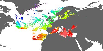
GHRSST Level 3C North Atlantic Regional (NAR) subskin Sea Surface Temperature from SNPP/VIIRS (GDS V2) produced by OSI SAF recent views
National Aeronautics and Space Administration —
A regional Group for High Resolution Sea Surface Temperature (GHRSST) Level 3 Collated (L3C) dataset for the North Atlantic Region (NAR) based on retrievals from the... -
Federal
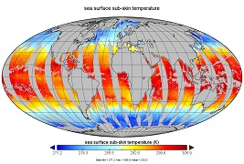
NOAA Smith and Reynolds Extended Reconstructed Sea Surface Temperature (ERSST) Level 4 Monthly Version 5 Dataset in netCDF recent views
National Aeronautics and Space Administration —
The Smith & Reynolds Extended Reconstructed Sea Surface Temperature (ERSST) Level 4 dataset provides a historical reconstruction of monthly global ocean surface... -
Federal
SASSIE Arctic Field Campaign Shipboard S-Band Radar Level 3 Data Fall 2022 recent views
National Aeronautics and Space Administration —
This dataset contains images from the S-BAND marine navigation radar collected during the 2022 Salinity and Stratification at the Sea Ice Edge (SASSIE) campaign.... -
Federal
ECCO Atmosphere Surface Temperature, Humidity, Wind, and Pressure - Daily Mean 0.5 Degree (Version 4 Release 4) recent views
National Aeronautics and Space Administration —
This dataset contains daily-averaged atmosphere surface temperature, humidity, wind, and pressure interpolated to a regular 0.5-degree grid from the ECCO Version 4... -
Federal
Multi-Mission Optimally Interpolated Sea Surface Salinity Global Dataset V2 recent views
National Aeronautics and Space Administration —
This is a level 4 product on a 0.25-degree spatial and 4-day temporal grid. The product is derived from the level 2 swath data of three satellite missions: the... -
Federal
ECCO Ocean 3D Gent-Mcwilliams, Redi, and Background Vertical Diffusivity Coefficients for the Lat-Lon-Cap 90 (llc90) Native Model Grid (Version 4 Release 4) recent views
National Aeronautics and Space Administration —
This dataset provides 3D coefficients for the Gent-McWilliams and Redi parameterizations and background vertical diffusivity on the lat-lon-cap 90 (llc90) native... -
Federal
ECCO Ocean and Sea-Ice Surface Freshwater Fluxes - Daily Mean 0.5 Degree (Version 4 Release 4) recent views
National Aeronautics and Space Administration —
This dataset contains daily-averaged ocean and sea-ice surface freshwater fluxes interpolated to a regular 0.5-degree grid from the ECCO Version 4 revision 4 (V4r4)... -
Federal
GHRSST Level 3C North Atlantic Regional Subskin Sea Surface Temperature from the Advanced Very High Resolution Radiometer (AVHRR) on NOAA-19 (GDS2 version) recent views
National Aeronautics and Space Administration —
A Group for High Resolution Sea Surface Temperature (GHRSST) dataset for the North Atlantic Region (NAR) from the Advanced Very High Resolution Radiometer (AVHRR) on... -
Federal
RSS SMAP Level 3 Sea Surface Salinity Standard Mapped Image 8-Day Running Mean V4.0 Validated Dataset recent views
National Aeronautics and Space Administration —
The version 4.0 SMAP-SSS level 3, 8-Day running mean gridded product is based on the fourth release of the validated standard mapped sea surface salinity (SSS) data... -
Federal
ECCO Ocean Velocity - Monthly Mean llc90 Grid (Version 4 Release 4) recent views
National Aeronautics and Space Administration —
This dataset provides monthly-averaged ocean velocity on the native Lat-Lon-Cap 90 (LLC90) model grid from the ECCO Version 4 Release 4 (V4r4) ocean and sea-ice state... -
Federal
ECCO Sea Surface Height - Daily Mean 0.5 Degree (Version 4 Release 4b) recent views
National Aeronautics and Space Administration —
This dataset contains daily-averaged dynamic sea surface height interpolated to a regular 0.5-degree grid from the ECCO Version 4 revision 4b (V4r4b) ocean and sea-... -
Federal
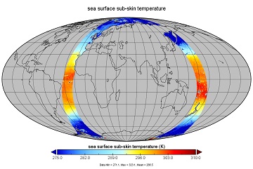
GHRSST Level 3U Global Global Near-Real Subskin Sea Surface Temperature version 8.2 (v8.2) from the Advanced Microwave Scanning Radiometer 2 (AMSR2) on the GCOM-W satellite by REMSS recent views
National Aeronautics and Space Administration —
This product contains a near-real-time (NRT) Level-3U Sea Surface Temperature (SST) (identified by "rt" within the file name) for the Group for High Resolution Sea... -
Federal
ECCO Ocean Mixed Layer Depth - Monthly Mean 0.5 Degree (Version 4 Release 4) recent views
National Aeronautics and Space Administration —
This dataset contains monthly-averaged ocean mixed layer depth interpolated to a regular 0.5-degree grid from the ECCO Version 4 revision 4 (V4r4) ocean and sea-ice... -
Federal
GHRSST Level 2P Global Subskin Sea Surface Temperature version 8.2 (v8.2) from the Advanced Microwave Scanning Radiometer 2 (AMSR2) by REMSS recent views
National Aeronautics and Space Administration —
This product provides a “Final” (Refined) Level-2 Sea Surface Temperature (SST) (currently identified by "v8.2" within the file name) for the Group for High...

Official websites use .gov
A
.gov website belongs to an official government
organization in the United States.
Secure .gov websites use HTTPS
A
lock (
) or https:// means you’ve safely connected to
the .gov website. Share sensitive information only on official,
secure websites.