
-
Federal
GPM IMERG Final Precipitation L3 1 day 0.1 degree x 0.1 degree V07 (GPM_3IMERGDF) at GES DISC
National Aeronautics and Space Administration —
Version 07 is the current version of the data set. Older versions will no longer be available and have been superseded by Version 07.The Integrated Multi-satellitE... -
Federal
AQUA MODIS High Resolution Level 3 daily aerosol data, 0.1x0.1 degree grid Version 001 (AER_DBDT_D10KM_L3_MODIS_AQUA) at GES DISC
National Aeronautics and Space Administration —
This High-Resolution (0.1 x 0.1 degree) Level 3 daily Aerosol Optical Depth (AOD) product is generated by combining two Moderate Resolution Imaging Spectroradiometer... -
Federal
TROPESS Chemical Reanalysis Lightning NOx emissions Monthly 2-dimensional Product V1 (TRPSCRENOXLM2D) at GES DISC
National Aeronautics and Space Administration —
The TROPESS Chemical Reanalysis Lightning NOx emissions Monthly 2-dimensional Product contains nitrogen oxides (NO and NO2) emissions from lightning strikes. The data... -
Federal
OMI/Aura Sulfur Dioxide (SO2) Total Column Daily L3 1 day Best Pixel in 0.25 degree x 0.25 degree V3 (OMSO2e) at GES DISC
National Aeronautics and Space Administration —
The OMI science team produces this Level-3 Aura/OMI Global OMSO2e Data Products (0.25 degree Latitude/Longitude grids). In this Level-3 daily global SO2 data product,... -
Federal
HAQAST Sentinel-5P TROPOMI Nitrogen Dioxide (NO2) CONUS Seasonal Level 3 0.01 x 0.01 Degree Gridded Data V2.4 (HAQ_TROPOMI_NO2_CONUS_S_L3) at GES DISC
National Aeronautics and Space Administration —
This product provides level 3 seasonal averages of tropospheric Nitrogen dioxide (NO2) vertical column density derived from the level 2 Tropospheric Monitoring... -
Federal
OMI/Aura NO2 Tropospheric, Stratospheric & Total Columns MINDS Daily L2 Global Gridded 0.25 degree x 0.25 degree V1.1 (OMI_MINDS_NO2G) at GES DISC
National Aeronautics and Space Administration —
As part of the NASA's Making Earth System Data Records for Use in Research Environments (MEaSUREs) program, this project entitled “Multi-Decadal Nitrogen Dioxide and... -
Federal
HAQAST Sentinel-5P TROPOMI Nitrogen Dioxide (NO2) CONUS Monthly Level 3 0.01 x 0.01 Degree Gridded Data V2.4 (HAQ_TROPOMI_NO2_CONUS_M_L3) at GES DISC
National Aeronautics and Space Administration —
This product provides level 3 monthly averages of tropospheric Nitrogen dioxide (NO2) vertical column density derived from the level 2 Tropospheric Monitoring... -
Federal
GPM IMERG Late Precipitation L3 1 day 0.1 degree x 0.1 degree V07 (GPM_3IMERGDL) at GES DISC
National Aeronautics and Space Administration —
Version 07 is the current version of the data set. Older versions will no longer be available and have been superseded by Version 07.The Integrated Multi-satellitE... -
Federal
GEOS-Carb CASA-GFED Daily Fire and Fuel Emissions 0.5 degree x 0.5 degree V3 (GEOS_CASAGFED_D_FIRE) at GES DISC
National Aeronautics and Space Administration —
This product provides Daily average wildfire emissions (FIRE) andfuel wood burning emissions (FUEL) derived from the Carnegie-Ames-Stanford-Approach – Global Fire... -
Federal
Sentinel-6A EUMETSAT GNSS-RO Non-Time-Critical Level 1B V1 (S6A_RO_1B_BND_____) at GES DISC
National Aeronautics and Space Administration —
This dataset provides the L1B Global Navigation Satellite System (GNSS) Radio-Occultation (RO) Non-Time-Critical (NTC) retrieval generated by European Organisation... -
Federal
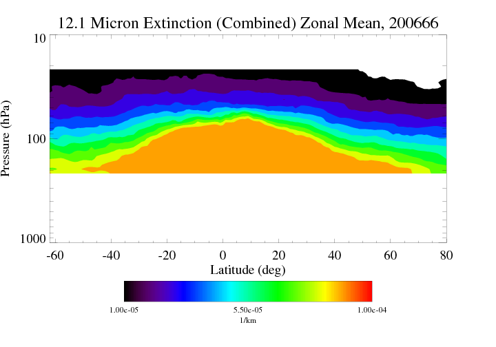
HIRDLS/Aura Level 3 Extinction at 12.1 Microns 1deg Lat Zonal Fourier Coefficients V007 (H3ZFC12MEXT) at GES DISC
National Aeronautics and Space Administration —
The "HIRDLS/Aura Level 3 Extinction at 12.1 Microns Zonal Fourier Coefficients" version 7 data product (H3ZFC12MEXT) contains the entire mission (~3 years) of HIRDLS... -
Federal
HRIR/Nimbus-1 Images of Nighttime Brightness Temperature on 70 mm Film V001 (HRIRN1IM) at GES DISC
National Aeronautics and Space Administration —
HRIRN1IM is the Nimbus-1 High-Resolution Infrared Radiometer (HRIR) data product containing scanned negatives of photofacsimile 70mm film strips. The images contain... -
Federal
HIRDLS/Aura Level 3 Chlorine Nitrate (ClONO2) 1deg Lat Zonal Fourier Coefficients V007 (H3ZFCCLONO2) at GES DISC
National Aeronautics and Space Administration —
The "HIRDLS/Aura Level 3 Chlorine Nitrate (ClONO2) Zonal Fourier Coefficients" version 7 data product (H3ZFCCLONO2) contains the entire mission (~3 years) of HIRDLS... -
Federal
MLS/Aura Level 3 Monthly Binned Carbon Monoxide (CO) Mixing Ratio on Assorted Grids V005 (ML3MBCO) at GES DISC
National Aeronautics and Space Administration —
ML3MBCO is the EOS Aura Microwave Limb Sounder (MLS) monthly binned on various vertical grids product for carbon monoxide (CO) derived from radiances measured by the... -
Federal
MLS/Aura Level 3 Daily Binned Hydrogen Cyanide (HCN) Mixing Ratio on Assorted Grids V004 (ML3DBHCN) at GES DISC
National Aeronautics and Space Administration —
ML3DBHCN is the EOS Aura Microwave Limb Sounder (MLS) daily binned on various vertical grids product for hydrogen cyanide (HCN) derived from radiances measured... -
Federal
Nimbus-6 Level 3 NMC Data Systems Test for the Global Atmospheric Research Program (GARP) V001 (NMCN6L3GARP) at GES DISC
National Aeronautics and Space Administration —
The NMCN6L3GARP is the Nimbus-6 Level 3 NMC Data Systems Test for the Global Atmospheric Research Program (GARP) product. The product consists of meterological... -
Federal
TSIS SIM Level 3 Solar Spectral Irradiance 24-Hour Means V13 (TSIS_SSI_L3_24HR) at GES DISC
National Aeronautics and Space Administration —
Version 13 is the current release of this data product, and supercedes all previous versions.The TSIS SIM Level 3 Solar Spectral Irradiance (SSI) 24-Hour Means data... -
Federal
VISSR/SMS-2 Level 1 Atmospheric and Oceanographic Image Processing System (AOIPS) Data V001 (VISSRSMS2L1AOIPS) at GES DISC
National Aeronautics and Space Administration —
VISSRSMS2L1AOIPS is the Visible Infrared Spin-Scan Radiometer (VISSR) Level 1 Atmospheric and Oceanographic Image Processing System (AOIPS) data product from the... -
Federal
TROPESS CrIS-SNPP L2 Ammonia for West Coast Fires, Standard Product V1 (TRPSDL2NH3CRSWCF) at GES DISC
National Aeronautics and Space Administration —
The TROPESS CrIS-SNPP L2 Ammonia for West Coast Fires, Standard Product contains the vertical distribution of the retrieved atmospheric state of ammonia (NH3), formal... -
Federal
THIR/Nimbus-7 Level 1 Calibrated Located Radiation Data at 6.7 and 11.5 microns V001 (THIRN7L1CLDT) at GES DISC
National Aeronautics and Space Administration —
THIRN7L1CLDT is the Nimbus-7 Temperature-Humidity Infrared Radiometer (THIR) Level 1 Calibrated Located Radiation Data (CLDT) at 6.7 and 11.5 microns product and...

Official websites use .gov
A
.gov website belongs to an official government
organization in the United States.
Secure .gov websites use HTTPS
A
lock (
) or https:// means you’ve safely connected to
the .gov website. Share sensitive information only on official,
secure websites.