
-
Federal
GLDAS Noah Land Surface Model L4 monthly 0.25 x 0.25 degree V2.1 (GLDAS_NOAH025_M) at GES DISC
National Aeronautics and Space Administration —
NASA Global Land Data Assimilation System Version 2 (GLDAS-2) has three components: GLDAS-2.0, GLDAS-2.1, and GLDAS-2.2. GLDAS-2.0 is forced entirely with the... -
Federal
Monthly Frequency of Dust Storm over Land for Varying Intensities, Based on MODIS Terra Deep Blue Level 2 Aerosol Products MOD04_L2 Collection 6.1, on a Global 0.1 by 0.1 Degree Grid, Level 3 Version 1 (MODFDS_MON_GLB_L3) at GES DISC
National Aeronautics and Space Administration —
Version 1 is the current version of the dataset.This collection MODFDS_MON_GLB_L3 provides level 3 monthly frequency of dust storms (FDS) over land from 175°W to... -
Federal
SBUV2/NOAA-18 Ozone (O3) Profile and Total Column Ozone 1 Month Zonal Mean L3 Global 5.0 degree Latitude Zones V1 (SBUV2N18L3zm) at GES DISC
National Aeronautics and Space Administration —
The Solar Backscattered Ultraviolet (SBUV) from NOAA-18 Level-3 monthly zonal mean (MZM) product (SBUV2N18L3zm) is derived from the Level-2 retrieved ozone profiles.... -
Federal
NASA Ocean Biogeochemical Model assimilating satellite chlorophyll data global monthly VR2017 (NOBM_MON) at GES DISC
National Aeronautics and Space Administration —
This is the assimilated monthly data from NASA Ocean Biogeochemical Model (NOBM). The NOBM is a comprehensive, interactive ocean biogeochemical model coupled with a... -
Federal
Carbon Monitoring System Lake Superior Primary Production Yearly V1 (CMSLakeSuperiorPPY) at GES DISC
National Aeronautics and Space Administration —
Yearly Average primary production/carbon fixation data for Lake Superior. The primary production data is derived using MODIS imagery with model data.The NASA Carbon... -
Federal
GPM SSMIS on F17 (GPROF) Radiometer Precipitation Profiling L2 1.5 hours 12 km V07 (GPM_2AGPROFF17SSMIS) at GES DISC
National Aeronautics and Space Administration —
Version 07 is the current version of the data set. Older versions will no longer be available and have been superseded by Version 07.The 2AGPROF (Goddard Profiling)... -
Federal
MERRA-2 tavgU_2d_adg_Nx: 2d,diurnal,Time-averaged,Single-Level,Assimilation,Aerosol Diagnostics (extended) 0.625 x 0.5 degree V5.12.4 (M2TUNXADG) at GES DISC
National Aeronautics and Space Administration —
M2TUNXADG (or tavgU_2d_adg_Nx) is a time-averaged 2-dimensional monthly diurnal means data collection in Modern-Era Retrospective analysis for Research and... -
Federal
GPM SSM/I on F14 (GPROF) Climate-based Radiometer Precipitation Profiling L2 1.5 hours 12 km V07 (GPM_2AGPROFF14SSMI_CLIM) at GES DISC
National Aeronautics and Space Administration —
Version 07 is the current version of the data set. Older versions will no longer be available and have been superseded by Version 07.The 'CLIM' products differ from... -
Federal
GPM SSMIS on F16 (GPROF) Climate-based Radiometer Precipitation Profiling 1.5 hours 12 km V07 (GPM_2AGPROFF16SSMIS_CLIM) at GES DISC
National Aeronautics and Space Administration —
Version 07 is the current version of the data set. Older versions will no longer be available and have been superseded by Version 07.The 'CLIM' products differ from... -
Federal
GPM MHS on METOP-B (GPROF) Radiometer Precipitation Profiling L2A 1.5 hours 17 km V07 (GPM_2AGPROFMETOPBMHS) at GES DISC
National Aeronautics and Space Administration —
Version 07 is the current version of the data set. Older versions will no longer be available and have been superseded by Version 07. The 2AGPROF (also known as, GPM... -
Federal
TROPESS CrIS-JPSS1 L2 Methane for Forward Stream, Summary Product V1 (TRPSYL2CH4CRS1FS) at GES DISC
National Aeronautics and Space Administration —
The TROPESS CrIS-JPSS1 L2 Methane for Forward Stream, Summary Product contains the vertical distribution of the retrieved atmospheric state of methane (CH4), and... -
Federal
GLDAS Catchment Land Surface Model L4 monthly 1.0 x 1.0 degree V2.1 (GLDAS_CLSM10_M) at GES DISC
National Aeronautics and Space Administration —
NASA Global Land Data Assimilation System Version 2 (GLDAS-2) has three components: GLDAS-2.0, GLDAS-2.1, and GLDAS-2.2. GLDAS-2.0 is forced entirely with the... -
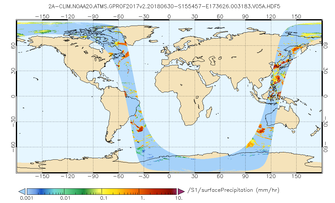
Federal
GPM ATMS on NOAA-20 (GPROF) Climate-based Radiometer Precipitation Profiling L2A 1.5 hours 17 km V07 (GPM_2AGPROFNOAA20ATMS_CLIM) at GES DISC
National Aeronautics and Space Administration —
Version 07 is the current version of the data set. The "CLIM" products differ from their "regular" counterparts (without the "CLIM" in the name) by the ancillary data... -
Federal
GLDAS Catchment Land Surface Model L4 daily 0.25 x 0.25 degree V2.0 (GLDAS_CLSM025_D) at GES DISC
National Aeronautics and Space Administration —
NASA Global Land Data Assimilation System Version 2 (GLDAS-2) has three components: GLDAS-2.0, GLDAS-2.1, and GLDAS-2.2. GLDAS-2.0 is forced entirely with the... -
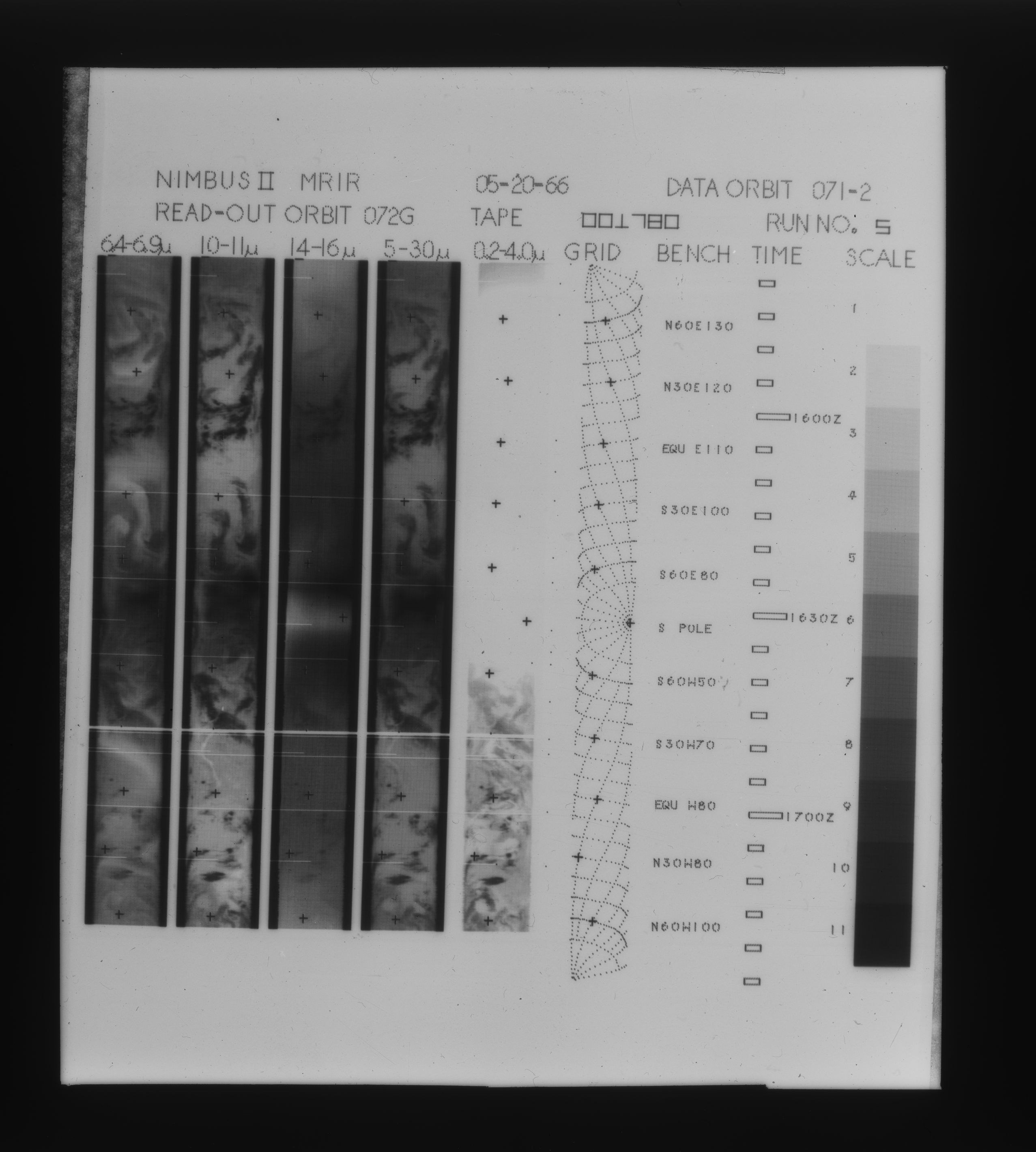
Federal
MRIR/Nimbus-2 Images of Daytime Brightness Temperature on 4 x 5 inch Film Sheets V001 (MRIRN2IM) at GES DISC
National Aeronautics and Space Administration —
MRIRN2IM is the Nimbus-2 Medium Resolution Infrared Radiometer (MRIR) data product consisting of 4 x 5 inch photographic film sheets. Each film sheet contains an... -
Federal
Carbon Monitoring System Carbon Flux Ocean Prior L4 V3 (CMSFluxOceanPrior)
National Aeronautics and Space Administration —
This dataset provides the Prior for the Carbon Flux for Ocean.The NASA Carbon Monitoring System (CMS) is designed to make significant contributions in characterizing,... -
Federal
GPM ATMS on NOAA-21 (GPROF) Radiometer Precipitation Profiling L2A 1.5 hours 17 km V07 (GPM_2AGPROFNOAA21ATMS) at GES DISC
National Aeronautics and Space Administration —
Version 07 is the current version of the data set. The 2AGPROF (also known as, GPM GPROF (Level 2)) algorithm retrieves consistent precipitation and related science... -
Federal
GPM ATMS on NOAA-21 (GPROF) Climate-based Radiometer Precipitation Profiling L2A 1.5 hours 17 km V07 (GPM_2AGPROFNOAA21ATMS_CLIM) at GES DISC
National Aeronautics and Space Administration —
Version 07 is the current version of the data set. The "CLIM" products differ from their "regular" counterparts (without the "CLIM" in the name) by the ancillary data... -
Federal
Aqua/AIRS L3 Daily Standard Physical Retrieval (AIRS+AMSU) 1 degree x 1 degree V7.0 at GES DISC
National Aeronautics and Space Administration —
The Atmospheric Infrared Sounder (AIRS) is a grating spectrometer (R = 1200) aboard the second Earth Observing System (EOS) polar-orbiting platform, EOS Aqua. In... -
Federal
GPM SSMIS on F17 (GPROF) Climate-based Radiometer Precipitation Profiling 1.5 hours 12 km V07 (GPM_2AGPROFF17SSMIS_CLIM) at GES DISC
National Aeronautics and Space Administration —
Version 07 is the current version of the data set. Older versions will no longer be available and have been superseded by Version 07.The 'CLIM' products differ from...

Official websites use .gov
A
.gov website belongs to an official government
organization in the United States.
Secure .gov websites use HTTPS
A
lock (
) or https:// means you’ve safely connected to
the .gov website. Share sensitive information only on official,
secure websites.