
-
Federal
HAQAST Sentinel-5P TROPOMI Nitrogen Dioxide (NO2) GLOBAL Monthly Level 3 0.1 x 0.1 Degree Gridded Data Version 2.4 (HAQ_TROPOMI_NO2_GLOBAL_M_L3) at GES DISC
National Aeronautics and Space Administration —
This product provides level 3 monthly averages of tropospheric Nitrogen dioxide (NO2) vertical column density derived from the level 2 Tropospheric Monitoring... -
Federal
GPM IMERG Final Precipitation L3 1 day 0.1 degree x 0.1 degree V07 (GPM_3IMERGDF) at GES DISC
National Aeronautics and Space Administration —
Version 07 is the current version of the data set. Older versions will no longer be available and have been superseded by Version 07.The Integrated Multi-satellitE... -
Federal
TERRA MODIS High Resolution Level 3 daily aerosol data, 0.1x0.1 degree grid Version 001 (AER_DBDT_D10KM_L3_MODIS_TERRA) at GES DISC
National Aeronautics and Space Administration —
This High-Resolution (0.1 x 0.1 degree) Level 3 daily Aerosol Optical Depth (AOD) product is generated by combining two Moderate Resolution Imaging Spectroradiometer... -
Federal
OMPS/NPP L1B NP Radiance EV Calibrated Geolocated Swath Orbital V2 (OMPS_NPP_NPEV_L1B) at GES DISC
National Aeronautics and Space Administration —
The OMPS-NPP L1B NP Radiance EV Calibrated Geolocated Swath Orbital collection contains calibrated and geolocated radiances from 300 to 380 nm measured by the OMPS... -
Federal
SBUV2/NOAA-18 Ozone (O3) Profile and Total Column Ozone 1 Month Zonal Mean L3 Global 5.0 degree Latitude Zones V1 (SBUV2N18L3zm) at GES DISC
National Aeronautics and Space Administration —
The Solar Backscattered Ultraviolet (SBUV) from NOAA-18 Level-3 monthly zonal mean (MZM) product (SBUV2N18L3zm) is derived from the Level-2 retrieved ozone profiles.... -
Federal
GLDAS Catchment Land Surface Model L4 daily 0.25 x 0.25 degree GRACE-DA1 V2.2 (GLDAS_CLSM025_DA1_D) at GES DISC
National Aeronautics and Space Administration —
NASA Global Land Data Assimilation System Version 2 (GLDAS-2) has three components: GLDAS-2.0, GLDAS-2.1, and GLDAS-2.2. GLDAS-2.0 is forced entirely with the... -
Federal
GEOS-Carb CASA-GFED Daily Fire and Fuel Emissions 0.5 degree x 0.5 degree V3 (GEOS_CASAGFED_D_FIRE) at GES DISC
National Aeronautics and Space Administration —
This product provides Daily average wildfire emissions (FIRE) andfuel wood burning emissions (FUEL) derived from the Carnegie-Ames-Stanford-Approach – Global Fire... -
Federal
AMSR-MODIS Boundary Layer Water Vapor L3 Monthly 1 degree x 1 degree V1 (AMMBLWV) at GES DISC
National Aeronautics and Space Administration —
This data set provides an estimate the marine boundary layer water vapor beneath uniform cloud fields. Microwave radiometry from AMSR-E and AMSR-2 provides the total... -
Federal
MLS/Aura Level 3 Daily Binned Relative Humidity With Respect To Ice (RHI) on Assorted Grids V005 (ML3DBRHI) at GES DISC
National Aeronautics and Space Administration —
ML3DBRHI is the EOS Aura Microwave Limb Sounder (MLS) daily binned on various vertical grids product for relative humidity with respect to ice (RHI) derived from... -
Federal
Sentinel-6A Level 2 GNSS Radio Occultation Near-Real-Time V1 (S6A_RO_2__NRT_NC__) at GES DISC
National Aeronautics and Space Administration —
This dataset provides the L2 Global Navigation Satellite System (GNSS) Radio-Occultation (RO) Near-Real-Time (NRT) retrieval generated by NASA's Jet Propulsion... -
Federal
MLS/Aura Level 3 Daily Binned Relative Humidity With Respect To Ice (RHI) on Zonal and Similar Grids V005 (ML3DZRHI) at GES DISC
National Aeronautics and Space Administration —
ML3DZRHI is the EOS Aura Microwave Limb Sounder (MLS) daily binned on zonal and assorted vertical grids product for relative humidity with respect to ice (RHI)... -
Federal
MERRA-2 instU_2d_asm_Nx: 2d,diurnal,Instantaneous,Single-Level,Assimilation,Single-Level Diagnostics 0.625 x 0.5 degree V5.12.4 (M2IUNXASM) at GES DISC
National Aeronautics and Space Administration —
M2IUNXASM (or instU_2d_asm_Nx) is an instantaneous 2-dimensional monthly diurnal means data collection in Modern-Era Retrospective analysis for Research and... -
Federal
MiCASA Daily NPP Rh ATMC NEE FIRE FUEL Fluxes 0.1 degree x 0.1 degree
National Aeronautics and Space Administration —
MiCASA is an extensive revision of CASA-GFED3. CASA-GFED3 derives from Potter et al. (1993), diverging in development since Randerson et al. (1996). CASA is a light... -
Federal
OMPS-NPP L2 LP Ozone (O3) Vertical Profile swath daily 3slit V2.5 (OMPS_NPP_LP_L2_O3_DAILY) at GES DISC
National Aeronautics and Space Administration —
The OMPS-NPP L2 LP Ozone (O3) Vertical Profile swath daily 3slit collection contains ozone measured by the Ozone Mapping and Profiling Suite (OMPS) Limb-Profiler (LP)... -
Federal
GLDAS CLM Land Surface Model L4 3 hourly 1.0 x 1.0 degree Subsetted V001 (GLDAS_CLM10SUBP_3H) at GES DISC
National Aeronautics and Space Administration —
With the upgraded Land Surface Models (LSMs) and updated forcing data sets, the GLDAS version 2.1 (GLDAS-2.1) production stream serves as a replacement for GLDAS-001.... -
Federal
MLS/Aura Level 2 Ozone (O3) Mixing Ratio V005 (ML2O3) at GES DISC
National Aeronautics and Space Administration —
ML2O3 is the EOS Aura Microwave Limb Sounder (MLS) standard product for ozone derived from radiances measured by the 240 GHz radiometer. The data version is 5.0.... -
Federal
Aqua/AIRS L2 Near Real Time (NRT) Standard Physical Retrieval (AIRS-only) V7.0 at GES DISC
National Aeronautics and Space Administration —
The Atmospheric Infrared Sounder (AIRS) Level 2 Near Real Time (NRT) Standard Physical Retrieval (AIRS-only) product (AIRS2RET_NRT_7.0) differs from the routine... -
Federal
Sounder SIPS: AQUA AIRS IR + MW Level 3 CLIMCAPS: Specific Quality Control Gridded Monthly V2 (SNDRAQIML3SMCCP) at GES DISC
National Aeronautics and Space Administration —
WARNING: To users of the derived product “co_mmr_midtrop” (carbon monoxide mass mixing ratio to dry air [kg/kg] at ~500 hPa). This variable has a significant bias due... -
Federal
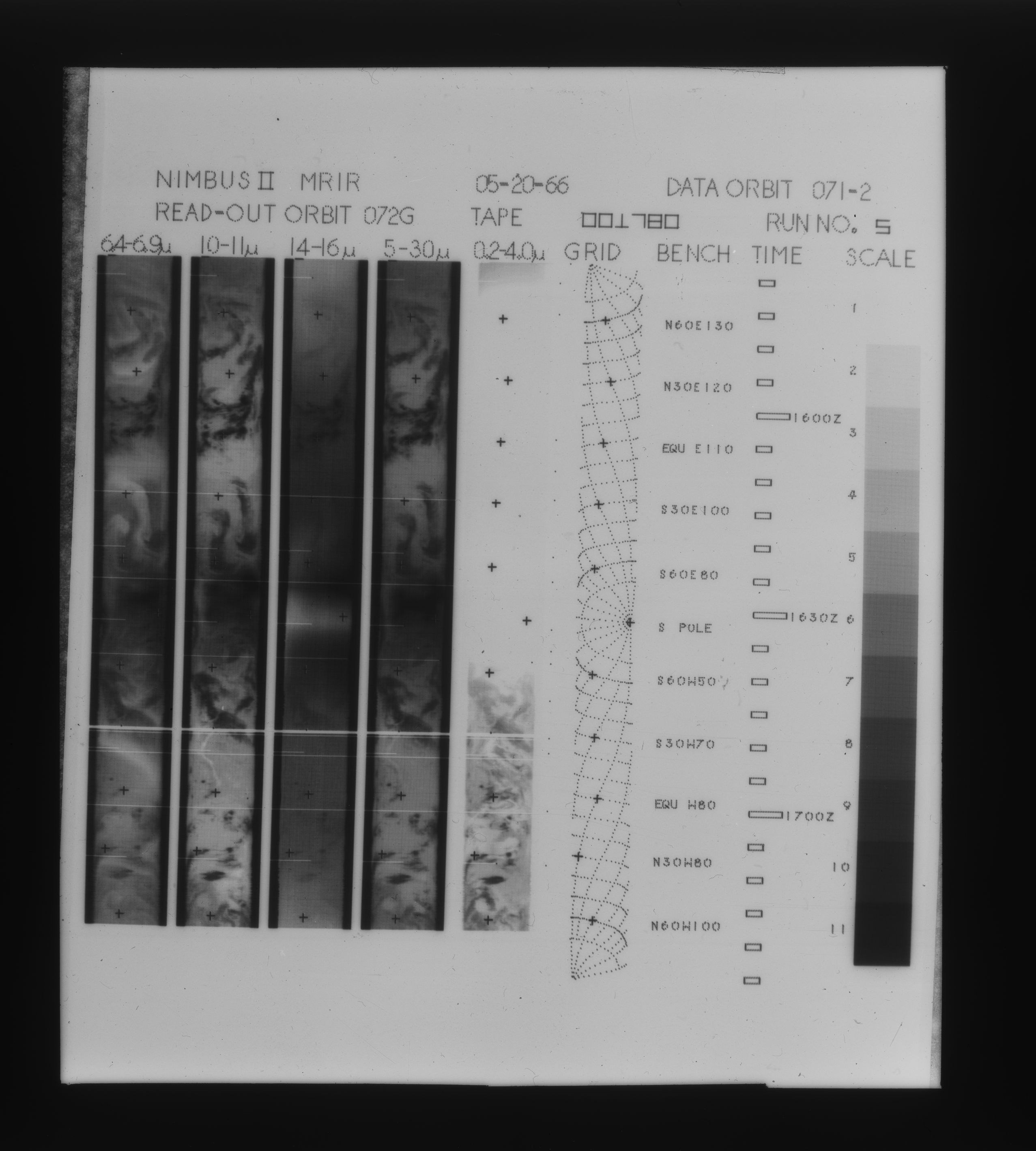
MRIR/Nimbus-2 Images of Daytime Brightness Temperature on 4 x 5 inch Film Sheets V001 (MRIRN2IM) at GES DISC
National Aeronautics and Space Administration —
MRIRN2IM is the Nimbus-2 Medium Resolution Infrared Radiometer (MRIR) data product consisting of 4 x 5 inch photographic film sheets. Each film sheet contains an... -
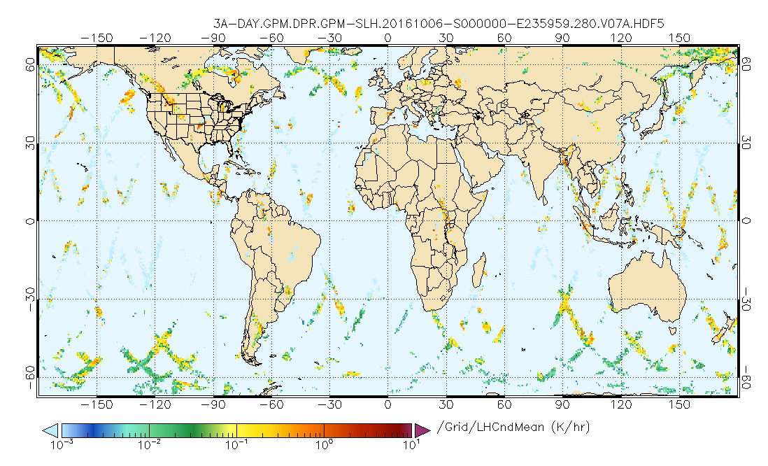
Federal
GPM DPR Spectral Latent Heating Profiles L3 1 day 0.5 degree x 0.5 degree V07 (GPM_3HSLH_DAY) at GES DISC
National Aeronautics and Space Administration —
Version 07 is the current version of the data set. Older versions will no longer be available and have been superseded by Version 07.The Gridded Spectral Latent...

Official websites use .gov
A
.gov website belongs to an official government
organization in the United States.
Secure .gov websites use HTTPS
A
lock (
) or https:// means you’ve safely connected to
the .gov website. Share sensitive information only on official,
secure websites.