
-
Federal
Sentinel-6A GNSS-POD Level 1B Daily RINEX V1 (S6A_GN_1B_RNXD_AX_) at GES DISC
National Aeronautics and Space Administration —
This dataset provides the L1B Global Navigation Satellite System (GNSS) Precise Orbit Determination (POD) data generated by European Organisation for the Exploitation... -
Federal
GPM IMERG Final Precipitation L3 1 day 0.1 degree x 0.1 degree V07 (GPM_3IMERGDF) at GES DISC
National Aeronautics and Space Administration —
Version 07 is the current version of the data set. Older versions will no longer be available and have been superseded by Version 07.The Integrated Multi-satellitE... -
Federal
Daily FluxSat GPP of biomass over Land, Based on MODIS Terra and Aqua adjusted reflectance Collection 6.1, on a Global 0.5 by 0.625 Degree Grid, Level 3 Version 2.2
National Aeronautics and Space Administration —
This dataset provides global gridded daily estimates of gross primary production (GPP) and uncertainties at 0.5 deg latitude by 0.625 deg longitude resolution for the... -
Federal
AQUA MODIS High Resolution Level 3 monthly aerosol data, 0.1x0.1 degree grid Version 001 (AER_DBDT_M10KM_L3_MODIS_AQUA) at GES DISC
National Aeronautics and Space Administration —
This High-Resolution (0.1 x 0.1 degree) Level 3 monthly Aerosol Optical Depth (AOD) product is generated by combining two Moderate Resolution Imaging... -
Federal
GPM IMERG Late Precipitation L3 1 day 0.1 degree x 0.1 degree V07 (GPM_3IMERGDL) at GES DISC
National Aeronautics and Space Administration —
Version 07 is the current version of the data set. Older versions will no longer be available and have been superseded by Version 07.The Integrated Multi-satellitE... -
Federal
Sentinel-6 NASA/JPL GNSS-RO Near-Real-Time Level 1B V1 (S6A_RO_1B_NRT_NC__) at GES DISC
National Aeronautics and Space Administration —
This dataset provides the L1B Global Navigation Satellite System (GNSS) Radio-Occultation (RO) Near-Real-Time (NRT) retrieval generated by NASA's Jet Propulsion... -
Federal
Sentinel-6A Level 1B GNSS Radio Occultation Daily RINEX V1 (S6A_RO_1B_POD_RNX_) at GES DISC
National Aeronautics and Space Administration —
This dataset provides the L1B Global Navigation Satellite System (GNSS) Radio Occultation (RO) Precise Orbit Determination (POD) data generated by NASA JPL from... -
Federal
MLS/Aura Level 3 Monthly Binned Hydroxyl (OH) Mixing Ratio on Assorted Grids V005 (ML3MBOH) at GES DISC
National Aeronautics and Space Administration —
ML3MBOH is the EOS Aura Microwave Limb Sounder (MLS) monthly binned on various vertical grids product for hydroxyl (OH) derived from radiances measured by the THz... -
Federal
Sounder SIPS: Suomi NPP CrIMSS Level 2 CLIMCAPS Normal Spectral Resolution: Atmospheric state at Standard Pressure Levels derived from CLIMCAPS V2.1 (SNDRSNIML2PLEVCPSN) at GES DISC
National Aeronautics and Space Administration —
The CLIMCAPS (Community Long-term Infrared Microwave Coupled Product System) algorithm is used to analyze data from the Cross-track Infrared Sounder/Advanced... -
Federal
GPM MHS on METOP-B (GPROF) Climate-based Radiometer Precipitation Profiling L3 1 day 0.25 degree x 0.25 degree V07 (GPM_3GPROFMETOPBMHS_DAY_CLIM) at GES DISC
National Aeronautics and Space Administration —
Version 07 is the current version of the data set. Older versions are no longer available and have been superseded by Version 07. The "CLIM" products differ from... -
Federal
SNPP VIIRS High Resolution Level 3 monthly aerosol data, 0.1x0.1 degree grid Version 001 (AER_DBDT_M10KM_L3_VIIRS_SNPP) at GES DISC
National Aeronautics and Space Administration —
This High-Resolution (0.1 x 0.1 degree) Level 3 monthly Aerosol Optical Depth (AOD) product is generated by combining two Visible Infrared Imaging Radiometer Suite... -
Federal
AQUA MODIS High Resolution Level 3 daily aerosol data, 0.1x0.1 degree grid Version 001 (AER_DBDT_D10KM_L3_MODIS_AQUA) at GES DISC
National Aeronautics and Space Administration —
This High-Resolution (0.1 x 0.1 degree) Level 3 daily Aerosol Optical Depth (AOD) product is generated by combining two Moderate Resolution Imaging Spectroradiometer... -
Federal
Sentinel-6A Level 2 GNSS Radio Occultation Near-Real-Time V1 (S6A_RO_2__NRT_NC__) at GES DISC
National Aeronautics and Space Administration —
This dataset provides the L2 Global Navigation Satellite System (GNSS) Radio-Occultation (RO) Near-Real-Time (NRT) retrieval generated by NASA's Jet Propulsion... -
Federal
MLS/Aura Level 2 Methyl Chloride (CH3CL) Mixing Ratio V005 (ML2CH3CL) at GES DISC
National Aeronautics and Space Administration —
ML2CH3CL is the EOS Aura Microwave Limb Sounder (MLS) standard product for methyl chloride derived from radiances measured by the 640 GHz radiometer. The data version... -
Federal
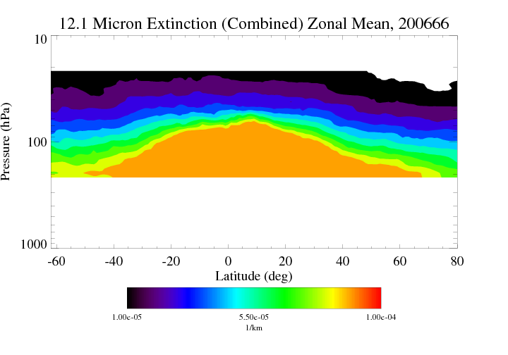
HIRDLS/Aura Level 3 Extinction at 12.1 Microns 1deg Lat Zonal Fourier Coefficients V007 (H3ZFC12MEXT) at GES DISC
National Aeronautics and Space Administration —
The "HIRDLS/Aura Level 3 Extinction at 12.1 Microns Zonal Fourier Coefficients" version 7 data product (H3ZFC12MEXT) contains the entire mission (~3 years) of HIRDLS... -
Federal
HIRS/Nimbus-6 Images of Brightness Temperature on 70 mm Film V001 (HIRSN6IM) at GES DISC
National Aeronautics and Space Administration —
The HIRSN6IM data product consists of images of brightness temperatures on 70 mm film strips from the Nimbus-6 High Resolution Infrared Radiation Sounder. Each... -
Federal
HIRDLS/Aura Level 3 Chlorine Nitrate (ClONO2) 1deg Lat Zonal Fourier Coefficients V007 (H3ZFCCLONO2) at GES DISC
National Aeronautics and Space Administration —
The "HIRDLS/Aura Level 3 Chlorine Nitrate (ClONO2) Zonal Fourier Coefficients" version 7 data product (H3ZFCCLONO2) contains the entire mission (~3 years) of HIRDLS... -
Federal
HIRDLS-MLS/Aura Level 3 Monthly 10 x 20 deg Ice Water Content V002 (HIRMLS3IWC) at GES DISC
National Aeronautics and Space Administration —
HIRMLS3IWC is the Joint EOS High Resolution Dynamics Limb Sounder (HIRDLS) and Microwave Limb Sounder (MLS) monthly 10 degreee lat x 20 degreee lon gridded product... -
Federal
MLS/Aura Level 3 Monthly Binned Carbon Monoxide (CO) Mixing Ratio on Assorted Grids V005 (ML3MBCO) at GES DISC
National Aeronautics and Space Administration —
ML3MBCO is the EOS Aura Microwave Limb Sounder (MLS) monthly binned on various vertical grids product for carbon monoxide (CO) derived from radiances measured by the... -
Federal
MLS/Aura Level 3 Monthly Binned Cloud Ice (IWC) on Assorted Grids V005 (ML3MBIWC) at GES DISC
National Aeronautics and Space Administration —
ML3MBIWC is the EOS Aura Microwave Limb Sounder (MLS) monthly binned on various vertical grids product for cloud ice water content (IWC) derived from radiances...

Official websites use .gov
A
.gov website belongs to an official government
organization in the United States.
Secure .gov websites use HTTPS
A
lock (
) or https:// means you’ve safely connected to
the .gov website. Share sensitive information only on official,
secure websites.