
-
Federal
Multisensor Advanced Climatology Mean Liquid Water Path L3 Monthly 1 degree X 1 degree V1 (MACLWP_mean) at GES DISC
National Aeronautics and Space Administration —
The Multi-Sensor Advanced Climatology of Liquid Water Path (MAC-LWP) data set contains monthly 1.0-degree ocean-only estimates of cloud liquid water path... -
Federal
Sounder SIPS: Suomi NPP CrIMSS Level 2 CLIMCAPS Normal Spectral Resolution: Atmospheric state at Standard Pressure Levels derived from CLIMCAPS V2.1 (SNDRSNIML2PLEVCPSN) at GES DISC
National Aeronautics and Space Administration —
The CLIMCAPS (Community Long-term Infrared Microwave Coupled Product System) algorithm is used to analyze data from the Cross-track Infrared Sounder/Advanced... -
Federal
Sounder SIPS: Suomi NPP CrIMSS Level 3 Specific Quality Control Gridded Daily CHART Normal Spectral Resolution V1
National Aeronautics and Space Administration —
The objective of this limited edition data collection is to examine products generated by the Climate Heritage AIRS Retrieval Technique (CHART) algorithm to analyze... -
Federal
GPM MHS on METOP-C (GPROF) Climate-based Radiometer Precipitation Profiling L2A 1.5 hours 17 km V07 (GPM_2AGPROFMETOPCMHS_CLIM) at GES DISC
National Aeronautics and Space Administration —
Version 07 is the current version of the data set. Older versions are no longer available and have been superseded by Version 07. The "CLIM" products differ from... -
Federal
VISSR/SMS-2 Level 1 Atmospheric and Oceanographic Image Processing System (AOIPS) Data V001 (VISSRSMS2L1AOIPS) at GES DISC
National Aeronautics and Space Administration —
VISSRSMS2L1AOIPS is the Visible Infrared Spin-Scan Radiometer (VISSR) Level 1 Atmospheric and Oceanographic Image Processing System (AOIPS) data product from the... -
Federal
THIR/Nimbus-7 Level 1 Calibrated Located Radiation Data at 6.7 and 11.5 microns V001 (THIRN7L1CLDT) at GES DISC
National Aeronautics and Space Administration —
THIRN7L1CLDT is the Nimbus-7 Temperature-Humidity Infrared Radiometer (THIR) Level 1 Calibrated Located Radiation Data (CLDT) at 6.7 and 11.5 microns product and... -
Federal
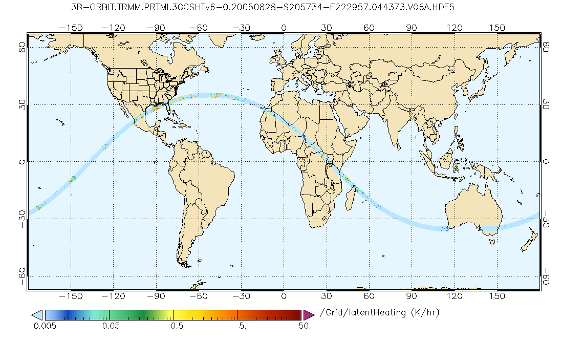
GPM PR and TMI on TRMM Combined Gridded Orbital Convective-Stratiform Latent Heating Profiles L3 1.5 hours 0.25x0.25 degree V07 (GPM_3GCSH_TRMM) at GES DISC
National Aeronautics and Space Administration —
This is the new (GPM-formated) TRMM product. It replaces the old TRMM legacy product TRMM_3G31.Version 07 is the current version of the data set. Older versions will... -
Federal
GPM PR and TMI on TRMM Combined Convective-Stratiform Latent Heating Profiles L3 1 month 0.25x0.25 degree V07 (GPM_3HCSH_TRMM) at GES DISC
National Aeronautics and Space Administration —
This is the new (GPM-formated) TRMM product. It replaces the old TRMM legacy TRMM_3H31Version 07 is the current version of the data set. Older versions will no longer... -
Federal
ESMR/Nimbus-5 Images of Brightness Temperature on 70 mm Film V001 (ESMRN5IM) at GES DISC
National Aeronautics and Space Administration —
ESMRN5IM is the Nimbus-5 Electrically Scanning Microwave Radiometer (ESMR) data product containing daily brightness temperature images from 70-mm photofacsimile film... -
Federal
NCEP/DOE Reanalysis II, for GSSTF, 0.25x0.25 deg, Monthly grid V3 (GSSTFM_NCEP) at GES DISC
National Aeronautics and Space Administration —
These data are the Goddard Satellite-based Surface Turbulent Fluxes Version 3 Dataset recently produced through a MEaSURES funded project led by Dr. Chung-Lin Shie... -
Federal
GPM PR on TRMM Spectral Latent Heating Profiles L2 1.5 hours 5 km V07 (GPM_2HSLH_TRMM) at GES DISC
National Aeronautics and Space Administration —
This a new (GPM-formated) TRMM product. There is no equivalent in the old TRMM suite of products.Version 07 is the current version of the data set. Older versions... -
Federal
GPM IMERG Final Precipitation L3 Half Hourly 0.1 degree x 0.1 degree V07 (GPM_3IMERGHH) at GES DISC
National Aeronautics and Space Administration —
Version 07B is the current version of the IMERG data sets. Older versions will no longer be available and have been superseded by Version 07.The Integrated Multi-... -
Federal
GPM SSMIS on F17 (GPROF) Radiometer Precipitation Profiling L2 1.5 hours 12 km V07 (GPM_2AGPROFF17SSMIS) at GES DISC
National Aeronautics and Space Administration —
Version 07 is the current version of the data set. Older versions will no longer be available and have been superseded by Version 07.The 2AGPROF (Goddard Profiling)... -
Federal
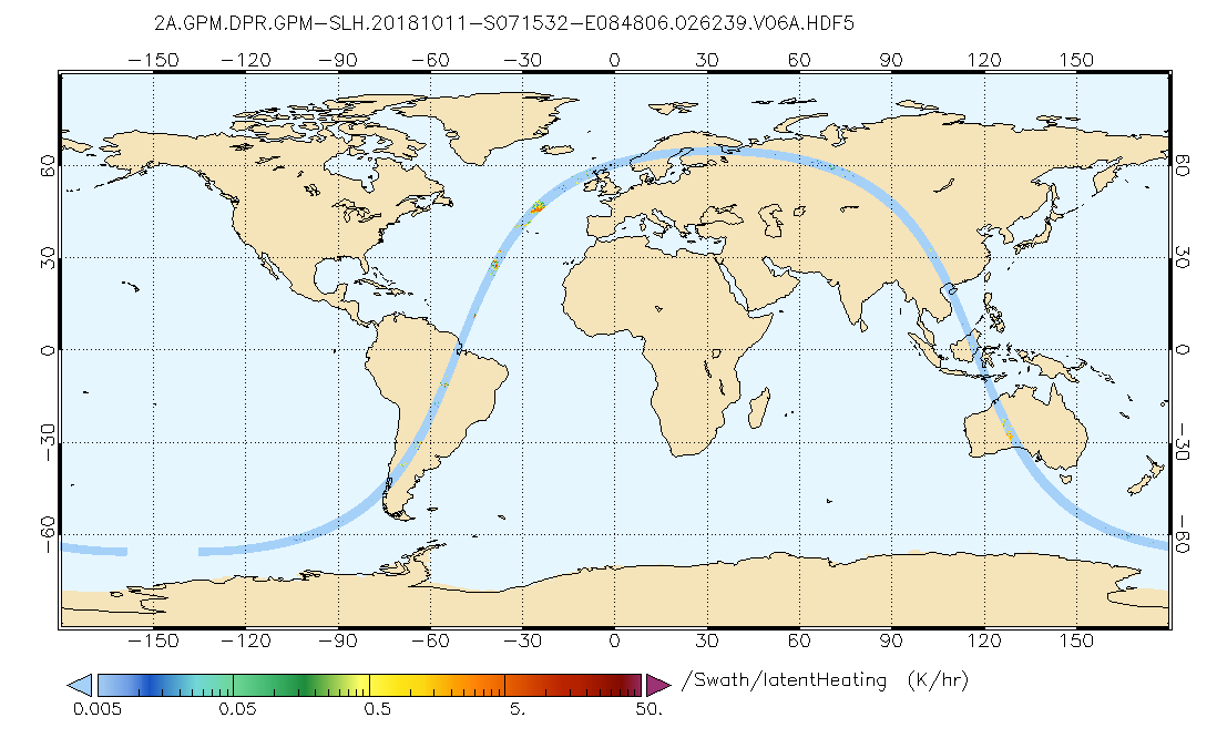
GPM DPR Spectral Latent Heating Profiles L2 1.5 hours 5 km V07 (GPM_2HSLH) at GES DISC
National Aeronautics and Space Administration —
Version 6B of these data were introduced in July, 2020. Please, see documentation tab for release notes. Latent heating variables are retrieved utilizing two separate... -
Federal
GPM MHS on NOAA-18 (GPROF) Radiometer Precipitation Profiling L2A 1.5 hours 17 km V07 (GPM_2AGPROFNOAA18MHS_CLIM) at GES DISC
National Aeronautics and Space Administration —
Version 07 is the current version of the data set. Older versions are no longer available and have been superseded by Version 07.The "CLIM" products differ from their... -
Federal
MRIR/Nimbus-3 Images of Daytime Brightness Temperature on 4 x 5 inch Film Sheets V001 (MRIRN3IM) at GES DISC
National Aeronautics and Space Administration —
MRIRN3IM is the Nimbus-3 Medium Resolution Infrared Radiometer (MRIR) data product consisting of 4 x 5 inch photographic film sheets. Each film sheet contains an... -
Federal
JPSS1 CrIS-VIIRS 750-m Matchup Indexes V1 (J1_CrIS_VIIRS750m_IND) at GES_DISC
National Aeronautics and Space Administration —
This dataset includes JPSS-1 VIIRS-CrIS collocation index product, within the framework of the Multidecadal Satellite Record of Water Vapor, Temperature, and Clouds... -
Federal
GPM SSMIS on F16 (GPROF) Radiometer Precipitation Profiling L2 1.5 hours 12 km V07 (GPM_2AGPROFF16SSMIS) at GES DISC
National Aeronautics and Space Administration —
Version 07 is the current version of the data set. Older versions will no longer be available and have been superseded by Version 07.The 2AGPROF (Goddard Profiling)... -
Federal
VISSR/SMS-1 Level 1 Atmospheric and Oceanographic Image Processing System (AOIPS) Data V001 (VISSRSMS1L1AOIPS) at GES DISC
National Aeronautics and Space Administration —
VISSRSMS1L1AOIPS is the Visible Infrared Spin-Scan Radiometer (VISSR) Level 1 Atmospheric and Oceanographic Image Processing System (AOIPS) data product from the... -
Federal
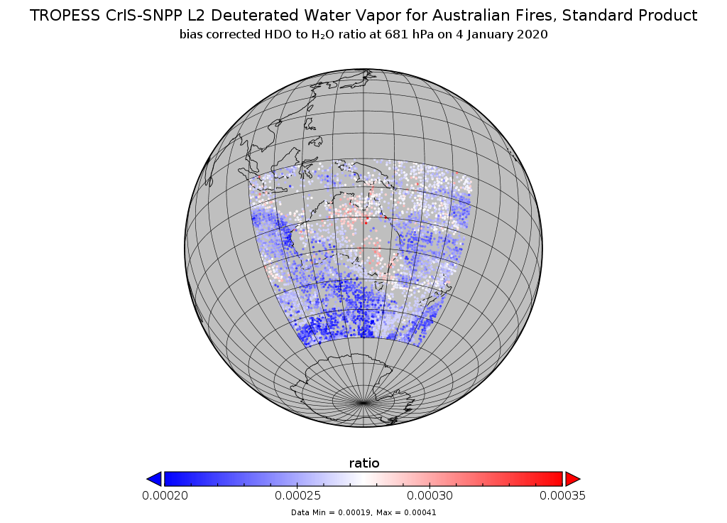
TROPESS CrIS-SNPP L2 Deuterated Water Vapor for Australian Fires, Standard Product V1 (TRPSDL2HDOCRSAUS) at GES DISC
National Aeronautics and Space Administration —
The TROPESS CrIS-SNPP L2 Deuterated Water Vapor for Australian Fires, Standard Product contains the vertical distribution of the retrieved atmospheric state of semi-...

Official websites use .gov
A
.gov website belongs to an official government
organization in the United States.
Secure .gov websites use HTTPS
A
lock (
) or https:// means you’ve safely connected to
the .gov website. Share sensitive information only on official,
secure websites.