
-
Federal
OMPS-NPP L2 NP Ozone (O3) Vertical Profile swath orbital
National Aeronautics and Space Administration —
The OMPS-NPP L2 NP Ozone (O3) Total Column swath orbital product provides ozone profile retrievals from the Ozone Mapping and Profiling Suite (OMPS) Nadir-Profiler... -
Federal
JPSS1 CrIS-VIIRS 750-m Matchup Indexes V1 (J1_CrIS_VIIRS750m_IND) at GES_DISC
National Aeronautics and Space Administration —
This dataset includes JPSS-1 VIIRS-CrIS collocation index product, within the framework of the Multidecadal Satellite Record of Water Vapor, Temperature, and Clouds... -
Federal
OMPS-NPP L2 LP Ozone (O3) Vertical Profile swath daily Center slit V2.6 (OMPS_NPP_LP_L2_O3_DAILY) at GES DISC
National Aeronautics and Space Administration —
Version 2.6 is the current version of this data product, and supersedes all previous versions.The OMPS-NPP L2 LP Ozone (O3) Vertical Profile swath daily Center slit... -
Federal
OMPS-NPP L2 NM Ozone (O3) Total Column swath orbital
National Aeronautics and Space Administration —
The OMPS-NPP L2 NM Ozone (O3) Total Column swath orbital product provides total ozone measurements from the Ozone Mapping and Profiling Suite (OMPS) Nadir-Mapper (NM)... -
Federal
OMPS-NPP L3 NM Ozone (O3) Total Column 1.0 deg grid daily V2
National Aeronautics and Space Administration —
The OMPS-NPP L3 NM Ozone (O3) Total Column 1.0 deg grid daily product provides total ozone measurements from the Ozone Mapping and Profiling Suite (OMPS) Nadir-Mapper... -
Federal
MiCASA Daily NPP Rh ATMC NEE FIRE FUEL Fluxes 0.1 degree x 0.1 degree
National Aeronautics and Space Administration —
MiCASA is an extensive revision of CASA-GFED3. CASA-GFED3 derives from Potter et al. (1993), diverging in development since Randerson et al. (1996). CASA is a light... -
Federal
OMPS-NPP L2 NM Sulfur Dioxide (SO2) Total and Tropospheric Column swath orbital V2 (OMPS_NPP_NMSO2_L2) at GES DISC
National Aeronautics and Space Administration —
The OMPS-NPP L2 NM Sulfur Dioxide (SO2) Total and Tropospheric Column swath orbital collection 2 version 2.0 product contains the retrieved sulfur dioxide (SO2)... -
Federal
OMPS-NPP L2 LP Ozone (O3) Vertical Profile swath daily 3slit V2.5 (OMPS_NPP_LP_L2_O3_DAILY) at GES DISC
National Aeronautics and Space Administration —
The OMPS-NPP L2 LP Ozone (O3) Vertical Profile swath daily 3slit collection contains ozone measured by the Ozone Mapping and Profiling Suite (OMPS) Limb-Profiler (LP)... -
Federal
CAR INTEXB BRDF Measurements L1 V2 (CAR_INTEXB_BRDF) at GES DISC
National Aeronautics and Space Administration —
INTEX-B (Intercontinental Chemical Transport Experiment-Phase B) focuses on the long-range transport of pollution, global atmospheric photochemistry, and the effects... -
Federal
Aqua AIRS-MLS Matchup Indexes V1.0 (AIRS_MLS_IND) at GES_DISC
National Aeronautics and Space Administration —
This dataset is part of MEaSUREs 2012 Program, and represent Aqua/AIRS-Aura/MLS collocation indexes, in netCDF-4 format. These data map AIRS profile indexes to those... -
Federal
MLS/Aura L1 Radiances from Filter Banks for THz V005 (ML1RADT) at GES DISC
National Aeronautics and Space Administration —
ML1RADT is the EOS Aura Microwave Limb Sounder (MLS) product containing the level 1 radiances from the filter banks for the GHz radiometers. The data version is 5.0.... -
Federal
OMPS-NPP L2 NP Ozone (O3) Vertical Profile swath orbital V2.9 (OMPS_NPP_NPBUVO3_L2) at GES DISC
National Aeronautics and Space Administration —
The OMPS-NPP L2 NP Ozone (O3) Total Column swath orbital product provides ozone profile retrievals from the Ozone Mapping and Profiling Suite (OMPS) Nadir-Profiler... -
Federal
MiCASA Monthly NPP Rh ATMC NEE FIRE FUEL Fluxes 0.1 degree x 0.1 degree
National Aeronautics and Space Administration —
MiCASA is an extensive revision of CASA-GFED3. CASA-GFED3 derives from Potter et al. (1993), diverging in development since Randerson et al. (1996). CASA is a light... -
Federal
MiCASA 3-hourly NPP NEE Fluxes 0.1 degree x 0.1 degree
National Aeronautics and Space Administration —
MiCASA is an extensive revision of CASA-GFED3. CASA-GFED3 derives from Potter et al. (1993), diverging in development since Randerson et al. (1996). CASA is a light... -
Federal
OMPS-N21 L2 LP Ozone (O3) Vertical Profile swath daily 3slit V1.0 (OMPS_N21_LP_L2_O3_DAILY) at GES DISC
National Aeronautics and Space Administration —
The OMPS-N21 L2 LP Ozone (O3) Vertical Profile swath daily 3slit collection contains ozone measured by the Ozone Mapping and Profiling Suite (OMPS) Limb-Profiler (LP)... -
Federal
OMPS-NPP L2 NM Nitrogen Dioxide (NO2) Total and Tropospheric Column swath orbital V2 (OMPS_NPP_NMNO2_L2) at GES DISC
National Aeronautics and Space Administration —
The OMPS-NPP L2 NM Nitrogen Dioxide (NO2) Total and Tropospheric Column swath orbital collection 2 version 2.0 product contains the retrieved nitrogen dioxide (NO2)... -
Federal
Standard Deviation of Monthly Frequency of Dust Storm over Land for Varying Intensities, Based on MODIS Terra Deep Blue Level 2 Aerosol Products MOD04_L2 Collection 6.1, on a Global 0.1 by 0.1 Degree Grid, Level 3 Version 1 (MODFDS_SDV_GLB_L3) at GES DISC
National Aeronautics and Space Administration —
Version 1 is the current version of the dataset.This collection MODFDS_SDV_GLB_L3 provides level 3 standard deviation of climatological monthly frequency of dust... -
Federal
SNPP CrIS-VIIRS 750-m Matchup Indexes V1 (SNPP_CrIS_VIIRS750m_IND) at GES_DISC
National Aeronautics and Space Administration —
This dataset includes SNPP VIIRS-CrIS collocation index product, within the framework of the Multidecadal Satellite Record of Water Vapor, Temperature, and Clouds... -
Federal
Aqua AIRS-MODIS 1-km Matchup Indexes V1 (Aqua_AIRS_MODIS1km_IND) at GES_DISC
National Aeronautics and Space Administration —
This dataset includes Aqua AIRS to MODIS 1-km collocation index product, within the framework of the Multidecadal Satellite Record of Water Vapor, Temperature, and... -
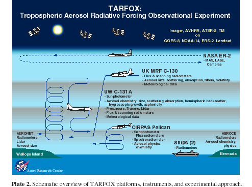
Federal
CAR TARFOX Tropospheric Aerosol Experiment BRDF V2 (CAR_TARFOX_BRDF) at GES DISC
National Aeronautics and Space Administration —
CAR TARFOX mission collected data in the western Atlantic Ocean on the effects of tropospheric aerosols on radiation budgets in cloud free skies. The mission also...

Official websites use .gov
A
.gov website belongs to an official government
organization in the United States.
Secure .gov websites use HTTPS
A
lock (
) or https:// means you’ve safely connected to
the .gov website. Share sensitive information only on official,
secure websites.