
-
Federal
GPM MHS on METOP-B (GPROF) Radiometer Precipitation Profiling L2A 1.5 hours 17 km V07 (GPM_2AGPROFMETOPBMHS) at GES DISC
National Aeronautics and Space Administration —
Version 07 is the current version of the data set. Older versions will no longer be available and have been superseded by Version 07. The 2AGPROF (also known as, GPM... -
Federal
GPM SSMI on F15 (GPROF) Climate-based Radiometer Precipitation Profiling L3 1 month 0.25 degree x 0.25 degree V07 (GPM_3GPROFF15SSMI_CLIM) at GES DISC
National Aeronautics and Space Administration —
Version 07 is the current version of the data set. Older versions will no longer be available and have been superseded by Version 07. The "CLIM" products differ from... -
Federal
GPM IMERG Final Precipitation L3 1 day 0.1 degree x 0.1 degree V07 (GPM_3IMERGDF) at GES DISC
National Aeronautics and Space Administration —
Version 07 is the current version of the data set. Older versions will no longer be available and have been superseded by Version 07.The Integrated Multi-satellitE... -
Federal
NOAA20 VIIRS High Resolution Level 3 daily aerosol data, 0.1x0.1 degree grid Version 001 (AER_DBDT_D10KM_L3_VIIRS_NOAA20) at GES DISC
National Aeronautics and Space Administration —
This High-Resolution (0.1 x 0.1 degree) Level 3 daily Aerosol Optical Depth (AOD) product is generated by combining two Visible Infrared Imaging Radiometer Suite... -
Federal
MLS/Aura Level 3 Monthly Binned Water Vapor (H2O) Mixing Ratio on Assorted Grids V004 (ML3MBH2O) at GES DISC
National Aeronautics and Space Administration —
ML3MBH2O is the EOS Aura Microwave Limb Sounder (MLS) monthly binned on various vertical grids product for water vapor (H2O) derived from radiances measured primarily... -
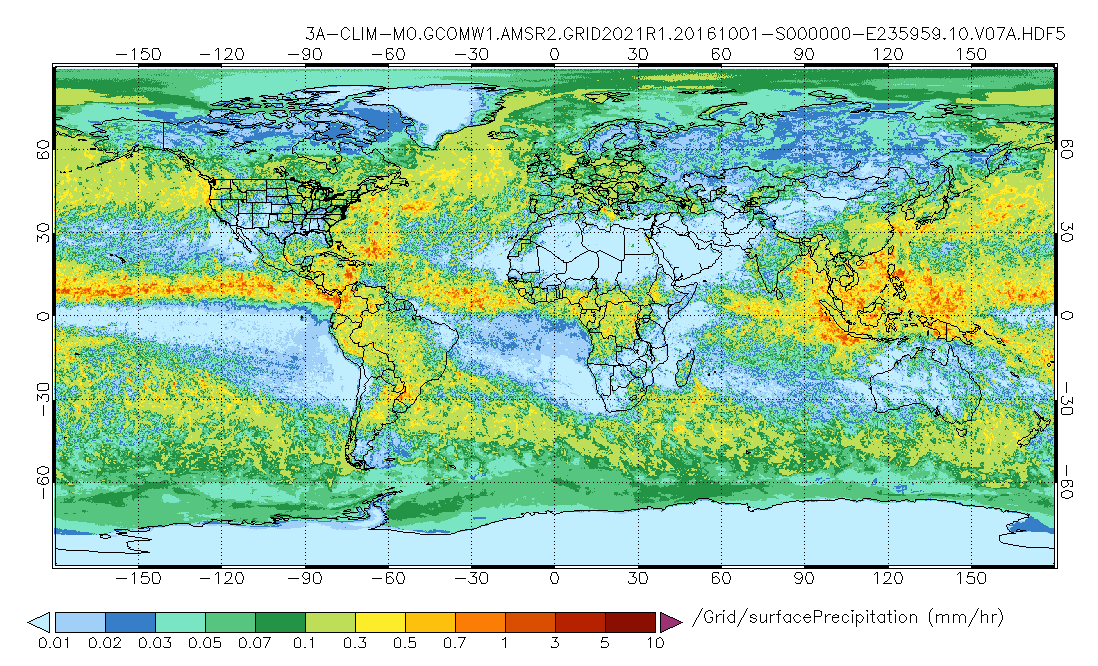
Federal
GPM AMSR-2 on GCOM-W1 (GPROF) Climate-based Radiometer Precipitation Profiling L3 1 month 0.25 degree x 0.25 degree V07 (GPM_3GPROFGCOMW1AMSR2_CLIM) at GES DISC
National Aeronautics and Space Administration —
Version 07 is the current version of the data set. Older versions will no longer be available and have been superseded by Version 07. The "CLIM" products differ from... -
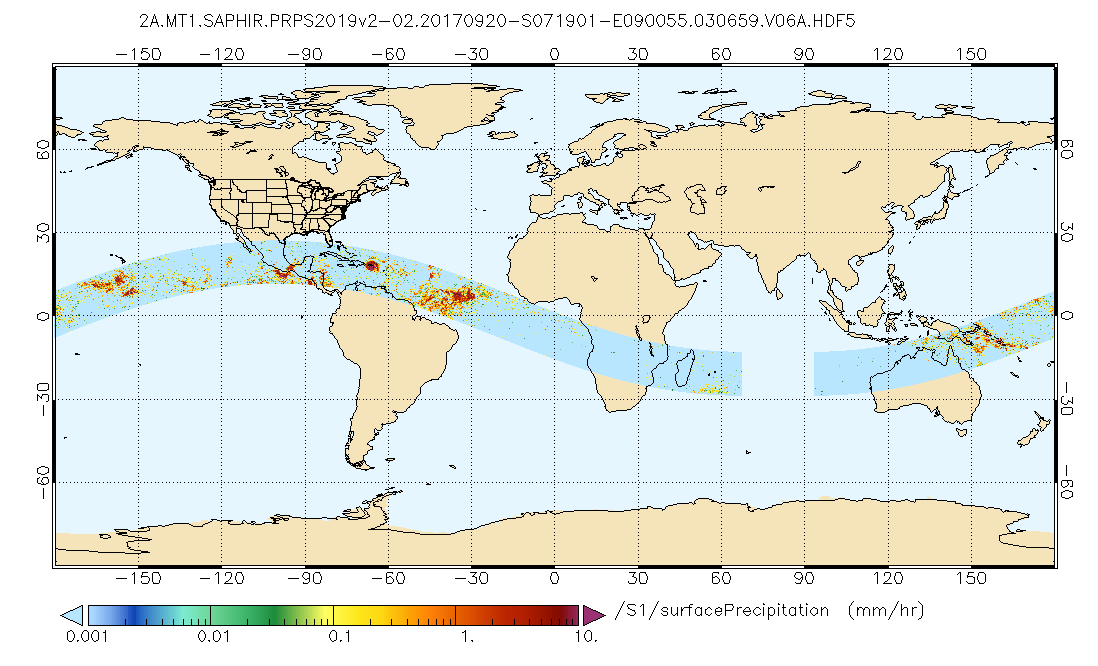
Federal
GPM SAPHIR on MT1 (PRPS) Radiometer Precipitation Profiling L2 1.5 hours 10 km V06 (GPM_2APRPSMT1SAPHIR) at GES DISC
National Aeronautics and Space Administration —
Version 6 is the current version of this dataset. Older versions are no longer available and have been superseded by Version 6.The Precipitation Retrieval and... -
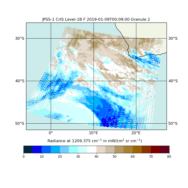
Federal
JPSS-1 CrIS Level 1B Full Spectral Resolution V2 (SNDRJ1CrISL1B) at GES DISC
National Aeronautics and Space Administration —
The Cross-track Infrared Sounder (CrIS) Level 1B Full Spectral Resolution (FSR) data files contain radiance measurements along with ancillary spacecraft, instrument,... -
Federal
CAR FIREACE Arctic Ice and Cloud Radiation BRDF V2 (CAR_FIREACE_BRDF) at GES DISC
National Aeronautics and Space Administration —
The scientific objectives of FIRE/ACE are to study impact of Arctic clouds on radiation exchange between surface, atmosphere, and space, and the influence of surface... -
Federal
VISSR/SMS-1 Visible Imagery on 70mm Film V001 (VISSRSMS1IMVIS) at GES DISC
National Aeronautics and Space Administration —
VISSRSMS1IMVIS is the Visible Infrared Spin-Scan Radiometer (VISSR) Visible Imagery on 70mm Film data product from the first Synchronous Meteorological Satellite... -
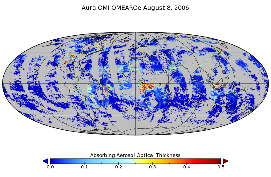
Federal
OMI/Aura Multi-wavelength Aerosol Optical Depth and Single Scattering Albedo L3 1 day Best Pixel in 0.25 degree x 0.25 degree V3 (OMAEROe) at GES DISC
National Aeronautics and Space Administration —
The OMI science team produces this Level-3 Aura/OMI Global Aerosol Data Products OMAEROe (0.25deg Lat/Lon grids). The OMAEROe product selects best aerosol value from... -
Federal
CAR CLAMS BRDF Measurements V2 (CAR_CLAMS_BRDF) at GES DISC
National Aeronautics and Space Administration —
CLAMS is the Chesapeake Lighthouse and Aircraft Measurements for Satellites field campaign sponsored by CERES, MISR, MODIS-Atmospheres and the NASA/GEWEX Global... -
Federal
NOAA20 VIIRS High Resolution Level 3 monthly aerosol data, 0.1x0.1 degree grid Version 001 (AER_DBDT_M10KM_L3_VIIRS_NOAA20) at GES DISC
National Aeronautics and Space Administration —
This High-Resolution (0.1 x 0.1 degree) Level 3 monthly Aerosol Optical Depth (AOD) product is generated by combining two Visible Infrared Imaging Radiometer Suite... -
Federal
OMPS/NPP L1B NM Radiance EV Calibrated Geolocated Swath Orbital V2 (OMPS_NPP_NMEV_L1B) at GES DISC
National Aeronautics and Space Administration —
The OMPS-NPP L1B NM Radiance EV Calibrated Geolocated Swath Orbital collection contains calibrated and geolocated radiances from 300 to 380 nm measured by the OMPS... -
Federal
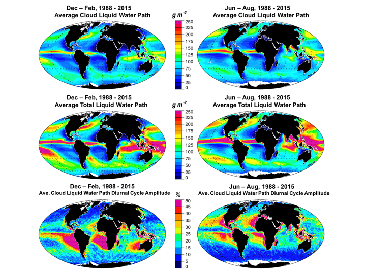
Multisensor Advanced Climatology Mean Liquid Water Path Diurnal Cycle L3 Monthly 1 degree x 1 degree V1 (MACLWP_diurnal) at GES DISC
National Aeronautics and Space Administration —
The Multi-Sensor Advanced Climatology of Liquid Water Path (MAC-LWP) data set contains monthly 1.0-degree ocean-only estimates of cloud liquid water path... -
Federal
HRIR/Nimbus-1 Images of Nighttime Brightness Temperature on 70 mm Film V001 (HRIRN1IM) at GES DISC
National Aeronautics and Space Administration —
HRIRN1IM is the Nimbus-1 High-Resolution Infrared Radiometer (HRIR) data product containing scanned negatives of photofacsimile 70mm film strips. The images contain... -
Federal
MLS/Aura Level 3 Daily Binned Water Vapor (H2O) Mixing Ratio on Assorted Grids V005 (ML3DBH2O) at GES DISC
National Aeronautics and Space Administration —
ML3DBH2O is the EOS Aura Microwave Limb Sounder (MLS) daily binned on various vertical grids product for water vapor (H2O) derived from radiances measured primarily... -
Federal
Sounder SIPS: JPSS-1 ATMS Level 2 RAMSES2 Standard: Atmosphere, precipitation and surface geophysical state V3 (SNDRJ1ML2RMS) at GES DISC
National Aeronautics and Space Administration —
This level 2 product is generated by the RAMSES (Retrieval Algorithm for Microwave Sounders in Earth Science II algorithm.The RAMSES II algorithm is a microwave only... -
Federal
Sounder SIPS: AQUA AIRS IR-only Level 2 CLIMCAPS: retrieved atmospheric state V2.1 (SNDRAQIL2CPS) at GES DISC
National Aeronautics and Space Administration —
The CLIMCAPS (Community Long-term Infrared Microwave Coupled Product System) algorithm is used to analyze data from the AIRS (Atmospheric Infrared Sounder). The AIRS... -
Federal
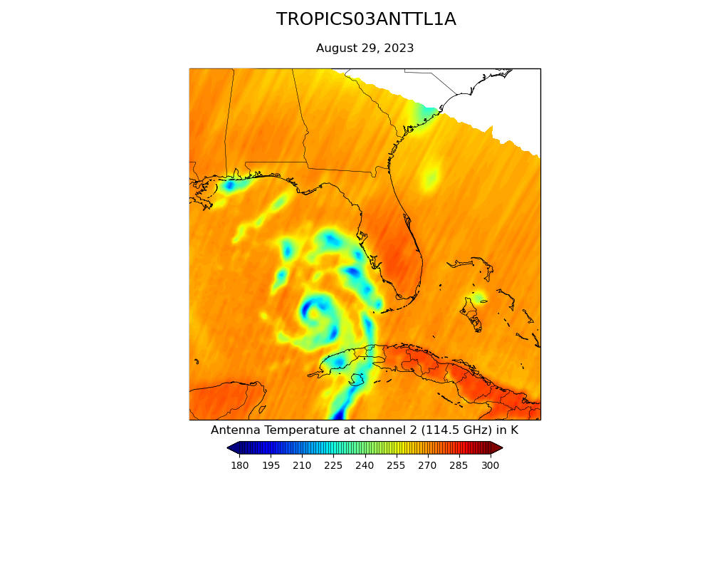
TROPICS05 L1A Orbital Geolocated Native-Resolution Antenna Temperatures V0.2
National Aeronautics and Space Administration —
The "Time-Resolved Observations of Precipitation structure and storm Intensity with a Constellation of Smallsats" (TROPICS) mission has a goal of providing nearly...

Official websites use .gov
A
.gov website belongs to an official government
organization in the United States.
Secure .gov websites use HTTPS
A
lock (
) or https:// means you’ve safely connected to
the .gov website. Share sensitive information only on official,
secure websites.