
-
Federal
OMPS-NPP L2 LP Aerosol Extinction Vertical Profile swath daily 3slit V2.5 (OMPS_NPP_LP_L2_AER_DAILY) at GES DISC
National Aeronautics and Space Administration —
The OMPS-NPP L2 LP Aerosol Extinction Vertical Profile swath daily 3slit (AER) product contains the retrieved aerosol extinction coefficients measured by the Ozone... -
Federal
THIR/Nimbus-6 Level 1 Meteorological Radiation Data at 6.7 microns V001 (THIRN6L1CH67) at GES DISC
National Aeronautics and Space Administration —
THIRN6L1CH67 is the Nimbus-6 Temperature-Humidity Infrared Radiometer (THIR) Level 1 Meteorological Radiation Data at 6.7 microns product and contains radiances... -
Federal
SCAMS/Nimbus-6 Images of Brightness Temperatures, Water Vapor and Temperature on 70-mm Film V001 (SCAMSN6IM) at GES DISC
National Aeronautics and Space Administration —
The SCAMSN6IM data product consists of images of brightness temperatures, water vapor and temperature on 70 mm film strips from the Nimbus-6 Scanning Microwave... -
Federal
NASA MEASURES Precipitation Ensemble based on SSMIS DMSP F18 NASA PPS L1C V05 Tbs 1-orbit L2 Swath 12x12km V1 (PRECIP_SSMIS_F18) at GES DISC
National Aeronautics and Space Administration —
The data presented in this level 2 orbital product are rain rate estimates expressed as mm/hour determined from brightness temperatures (Tbs) obtained from the... -
Federal
OMI/Aura NO2 Tropospheric, Stratospheric & Total Columns MINDS 1-Orbit L2 Swath 13 km x 24 km V1.1 (OMI_MINDS_NO2) at GES DISC
National Aeronautics and Space Administration —
As part of the NASA's Making Earth System Data Records for Use in Research Environments (MEaSUREs) program, this project entitled “Multi-Decadal Nitrogen Dioxide and... -
Federal
VISSR/SMS-1 Visible Imagery on 70mm Film V001 (VISSRSMS1IMVIS) at GES DISC
National Aeronautics and Space Administration —
VISSRSMS1IMVIS is the Visible Infrared Spin-Scan Radiometer (VISSR) Visible Imagery on 70mm Film data product from the first Synchronous Meteorological Satellite... -
Federal
SBUV2/NOAA-11 Ozone (O3) Profile and Total Column Ozone 1 Month Zonal Mean L3 Global 5.0 degree Latitude Zones V1 (SBUV2N11L3zm) at GES DISC
National Aeronautics and Space Administration —
The Solar Backscattered Ultraviolet (SBUV) from NOAA-11 Level-3 monthly zonal mean (MZM) product (SBUV2N11L3zm) is derived from the Level-2 retrieved ozone profiles.... -
Federal
CAR SCAR-B BRDF Measurements L1 V2 (CAR_SCARB_BRDF) at GES DISC
National Aeronautics and Space Administration —
The objectives for the SCAR mission are to advance our knowledge of how the physical, chemical and radiative processes in our atmosphere are affected by sulfate... -
Federal
OMPS-NPP L2 LP Ozone (O3) Vertical Profile swath daily 3slit V2.5 (OMPS_NPP_LP_L2_O3_DAILY) at GES DISC
National Aeronautics and Space Administration —
The OMPS-NPP L2 LP Ozone (O3) Vertical Profile swath daily 3slit collection contains ozone measured by the Ozone Mapping and Profiling Suite (OMPS) Limb-Profiler (LP)... -
Federal
Multi-Satellite Lambertian Equivalent Reflectivity (Local Satellite Time) 10-Day L3 Global 2.0x5.0deg Lat/Lon Grid V1 (MSLERLSTL3d10) at GES DISC
National Aeronautics and Space Administration —
The Multi-Satellite Lambertian Equivalent Reflectivity (Local Satellite Time) 10-Day L3 Global 2.0x5.0deg Lat/Lon Grid data product is derived from multi-satellite... -
Federal
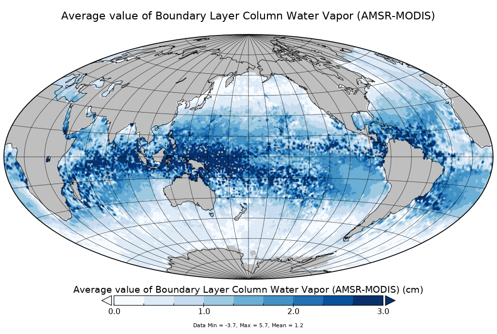
AMSR-MODIS Boundary Layer Water Vapor L3 Monthly 1 degree x 1 degree V2 (AMMBLWV) at GES DISC
National Aeronautics and Space Administration —
Version 2 is the current version of this dataset. Version 2 uses an improved methodology to screen out high clouds.This data set provides an estimate the marine... -
Federal
GPM MHS on METOP-C (GPROF) Climate-based Radiometer Precipitation Profiling L2A 1.5 hours 17 km V07 (GPM_2AGPROFMETOPCMHS_CLIM) at GES DISC
National Aeronautics and Space Administration —
Version 07 is the current version of the data set. Older versions are no longer available and have been superseded by Version 07. The "CLIM" products differ from... -
Federal
HIRS/Nimbus-6 Images of Brightness Temperature on 70 mm Film V001 (HIRSN6IM) at GES DISC
National Aeronautics and Space Administration —
The HIRSN6IM data product consists of images of brightness temperatures on 70 mm film strips from the Nimbus-6 High Resolution Infrared Radiation Sounder. Each... -
Federal
GPM SSMIS on F18 (GPROF) Climate-based Radiometer Precipitation Profiling L3 1 month 0.25 degree x 0.25 degree V07 (GPM_3GPROFF18SSMIS_CLIM) at GES DISC
National Aeronautics and Space Administration —
Version 07 is the current version of the data set. Older versions will no longer be available and have been superseded by Version 07. The "CLIM" products differ from... -
Federal
GPM SSMIS on F18 Common Calibrated Brightness Temperatures L1C 1.5 hours 12 km V07 (GPM_1CF18SSMIS) at GES DISC
National Aeronautics and Space Administration —
Version 07 is the current version of the data set. Older versions will no longer be available and have been superseded by Version 07.All 1C products have a common L1C... -
Federal
GPM SSMIS on F18 (GPROF) Radiometer Precipitation Profiling L3 1 day 0.25 degree x 0.25 degree V07 (GPM_3GPROFF18SSMIS_DAY) at GES DISC
National Aeronautics and Space Administration —
Version 07 is the current version of the data set. Older versions will no longer be available and have been superseded by Version 07.3GPROF products provide global... -
Federal
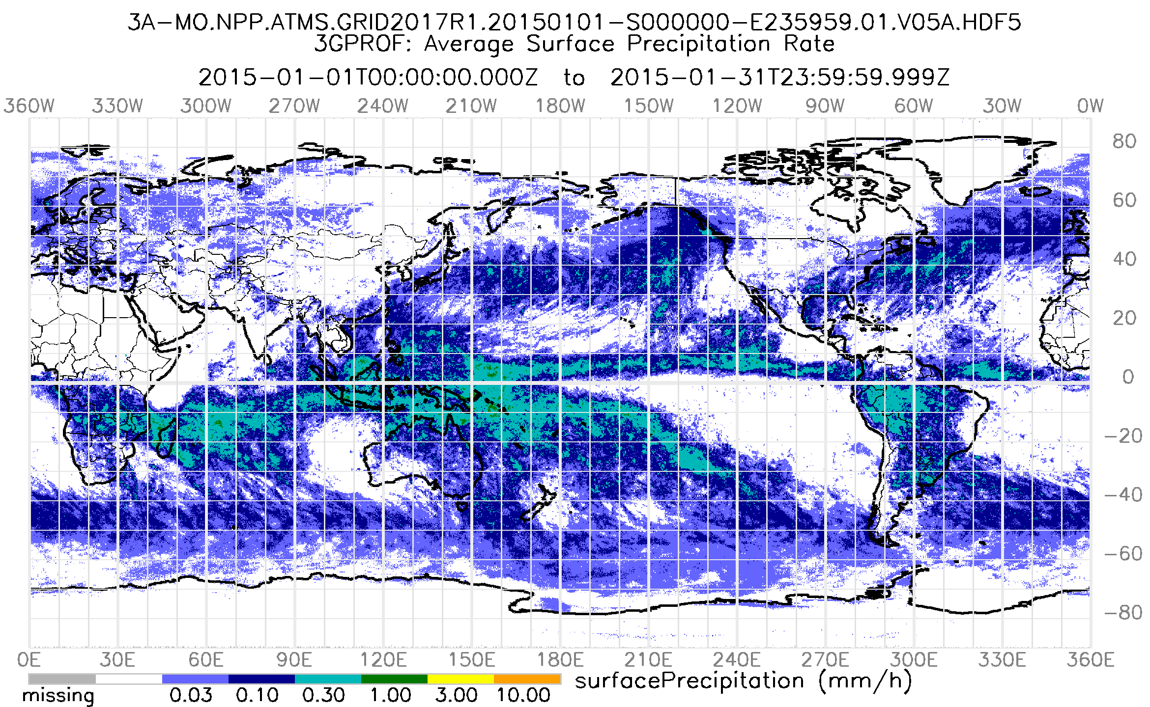
GPM ATMS on SUOMI-NPP (GPROF) Radiometer Precipitation Profiling L3 1 month 0.25 degree x 0.25 degree V07 (GPM_3GPROFNPPATMS) at GES DISC
National Aeronautics and Space Administration —
3GPROF products provide global gridded monthly/daily precipitation averages from multiple satellites that can be used for climate studies. The 3GPROF products are... -
Federal
GPM SSMIS on F18 (GPROF) Climate-based Radiometer Precipitation Profiling L3 1 day 0.25 degree x 0.25 degree V07 (GPM_3GPROFF18SSMIS_DAY_CLIM) at GES DISC
National Aeronautics and Space Administration —
Version 07 is the current version of the data set. Older versions will no longer be available and have been superseded by Version 07. The 'CLIM' products differ from... -
Federal
GPM SSMIS on F17 (GPROF) Climate-based Radiometer Precipitation Profiling 1.5 hours 12 km V07 (GPM_2AGPROFF17SSMIS_CLIM) at GES DISC
National Aeronautics and Space Administration —
Version 07 is the current version of the data set. Older versions will no longer be available and have been superseded by Version 07.The 'CLIM' products differ from... -
Federal
GPM SSM/I on F10 (GPROF) Climate-based Radiometer Precipitation Profiling L2 1.5 hours 12 km V07 (GPM_2AGPROFF10SSMI_CLIM) at GES DISC
National Aeronautics and Space Administration —
Version 7 is the current version of the data set. Older versions will no longer be available and have been superseded by the current version.The 'CLIM' products...

Official websites use .gov
A
.gov website belongs to an official government
organization in the United States.
Secure .gov websites use HTTPS
A
lock (
) or https:// means you’ve safely connected to
the .gov website. Share sensitive information only on official,
secure websites.