
-
Federal
GLDAS Noah Land Surface Model L4 monthly 0.25 x 0.25 degree V2.1 (GLDAS_NOAH025_M) at GES DISC
National Aeronautics and Space Administration —
NASA Global Land Data Assimilation System Version 2 (GLDAS-2) has three components: GLDAS-2.0, GLDAS-2.1, and GLDAS-2.2. GLDAS-2.0 is forced entirely with the... -
Federal
GLDAS Catchment Land Surface Model L4 monthly 1.0 x 1.0 degree V2.0 (GLDAS_CLSM10_M) at GES DISC
National Aeronautics and Space Administration —
NASA Global Land Data Assimilation System Version 2 (GLDAS-2) has three components: GLDAS-2.0, GLDAS-2.1, and GLDAS-2.2. GLDAS-2.0 is forced entirely with the... -
Federal
GLDAS Noah Land Surface Model L4 3 hourly 0.25 x 0.25 degree V2.0 (GLDAS_NOAH025_3H) at GES DISC
National Aeronautics and Space Administration —
NASA Global Land Data Assimilation System Version 2 (GLDAS-2) has three components: GLDAS-2.0, GLDAS-2.1, and GLDAS-2.2. GLDAS-2.0 is forced entirely with the... -
Federal
Sentinel-6 NASA/JPL GNSS-RO Non-Time-Critical Level 1B V1 (S6A_RO_1B_NTC_NC__) at GES DISC
National Aeronautics and Space Administration —
This dataset provides the L1B Global Navigation Satellite System (GNSS) Radio-Occultation (RO) Non-Time-Critical (NTC) retrieval generated by NASA's Jet Propulsion... -
Federal
Sounder SIPS: Suomi NPP CrIMSS Level 2 CLIMCAPS Full Spectral Resolution: Cloud Cleared Radiances V2 (SNDRSNIML2CCPCCR) at GES DISC
National Aeronautics and Space Administration —
The CLIMCAPS (Community Long-term Infrared Microwave Coupled Product System) algorithm is used to analyze data from the Cross-track Infrared Sounder/Advanced... -
Federal
GLDAS Noah Land Surface Model L4 monthly 1.0 x 1.0 degree V2.0 (GLDAS_NOAH10_M) at GES DISC
National Aeronautics and Space Administration —
NASA Global Land Data Assimilation System Version 2 (GLDAS-2) has three components: GLDAS-2.0, GLDAS-2.1, and GLDAS-2.2. GLDAS-2.0 is forced entirely with the... -
Federal
Sentinel-5P TROPOMI Total Ozone Column 1-Orbit L2 5.5km x 3.5km V1 (S5P_L2__O3_TOT_HiR) at GES DISC
National Aeronautics and Space Administration —
Starting from August 6th in 2019, Sentinel-5P TROPOMI along-track high spatial resolution (~5.5km at nadir) has been implemented.Starting from July 13th in 2020, five... -
Federal
AIRS/Aqua L1B AMSU (A1/A2) geolocated and calibrated brightness temperatures V005 (AIRABRAD) at GES DISC
National Aeronautics and Space Administration —
The Atmospheric Infrared Sounder (AIRS) is a grating spectrometer (R = 1200) aboard the second Earth Observing System (EOS) polar-orbiting platform, EOS Aqua. In... -
Federal
GLDAS Catchment Land Surface Model L4 daily 0.25 x 0.25 degree V2.0 (GLDAS_CLSM025_D) at GES DISC
National Aeronautics and Space Administration —
NASA Global Land Data Assimilation System Version 2 (GLDAS-2) has three components: GLDAS-2.0, GLDAS-2.1, and GLDAS-2.2. GLDAS-2.0 is forced entirely with the... -
Federal
GLDAS Noah Land Surface Model L4 monthly 0.25 x 0.25 degree V2.0 (GLDAS_NOAH025_M) at GES DISC
National Aeronautics and Space Administration —
NASA Global Land Data Assimilation System Version 2 (GLDAS-2) has three components: GLDAS-2.0, GLDAS-2.1, and GLDAS-2.2. GLDAS-2.0 is forced entirely with the... -
Federal
GLDAS Catchment Land Surface Model L4 monthly 1.0 x 1.0 degree V2.1 (GLDAS_CLSM10_M) at GES DISC
National Aeronautics and Space Administration —
NASA Global Land Data Assimilation System Version 2 (GLDAS-2) has three components: GLDAS-2.0, GLDAS-2.1, and GLDAS-2.2. GLDAS-2.0 is forced entirely with the... -
Federal
HIRS/Nimbus-6 Level 1 Calibrated Radiances for the Global Atmospheric Research Program (GARP) V001 (HIRSN6L1GARP) at GES DISC
National Aeronautics and Space Administration —
The Nimbus-6 High Resolution Infrared Radiometer (HIRS) Level 1 Calibrated Radiances for the Global Atmospheric Research Program (GARP) data product contains daily... -
Federal
MLS/Aura Level 3 Monthly Binned Carbon Monoxide (CO) Mixing Ratio on Assorted Grids V005 (ML3MBCO) at GES DISC
National Aeronautics and Space Administration —
ML3MBCO is the EOS Aura Microwave Limb Sounder (MLS) monthly binned on various vertical grids product for carbon monoxide (CO) derived from radiances measured by the... -
Federal
MiCASA Daily NPP Rh ATMC NEE FIRE FUEL Fluxes 0.1 degree x 0.1 degree
National Aeronautics and Space Administration —
MiCASA is an extensive revision of CASA-GFED3. CASA-GFED3 derives from Potter et al. (1993), diverging in development since Randerson et al. (1996). CASA is a light... -
Federal
GPM MHS on METOP-C (GPROF) Climate-based Radiometer Precipitation Profiling L2A 1.5 hours 17 km V07 (GPM_2AGPROFMETOPCMHS_CLIM) at GES DISC
National Aeronautics and Space Administration —
Version 07 is the current version of the data set. Older versions are no longer available and have been superseded by Version 07. The "CLIM" products differ from... -
Federal
TROPESS Chemical Reanalysis Surface Pressure Monthly 2-dimensional Product V1 (TRPSCRPSM2D) at GES DISC
National Aeronautics and Space Administration —
The TROPESS Chemical Reanalysis PS Monthly 2-dimensional Product contains surface pressure values, a meteorological field. The data are part of the Tropospheric... -
Federal
TROPICS05 L1B Orbital Geolocated Native-Resolution Brightness Temperatures V0.2
National Aeronautics and Space Administration —
The "Time-Resolved Observations of Precipitation structure and storm Intensity with a Constellation of Smallsats" (TROPICS) mission has a goal of providing nearly... -
Federal
GLDAS Noah Land Surface Model L4 3 hourly 0.25 x 0.25 degree Early Product V2.1 (GLDAS_NOAH025_3H_EP) at GES DISC
National Aeronautics and Space Administration —
NASA Global Land Data Assimilation System Version 2 (GLDAS-2) has three components: GLDAS-2.0, GLDAS-2.1, and GLDAS-2.2. GLDAS-2.0 is forced entirely with the... -
Federal
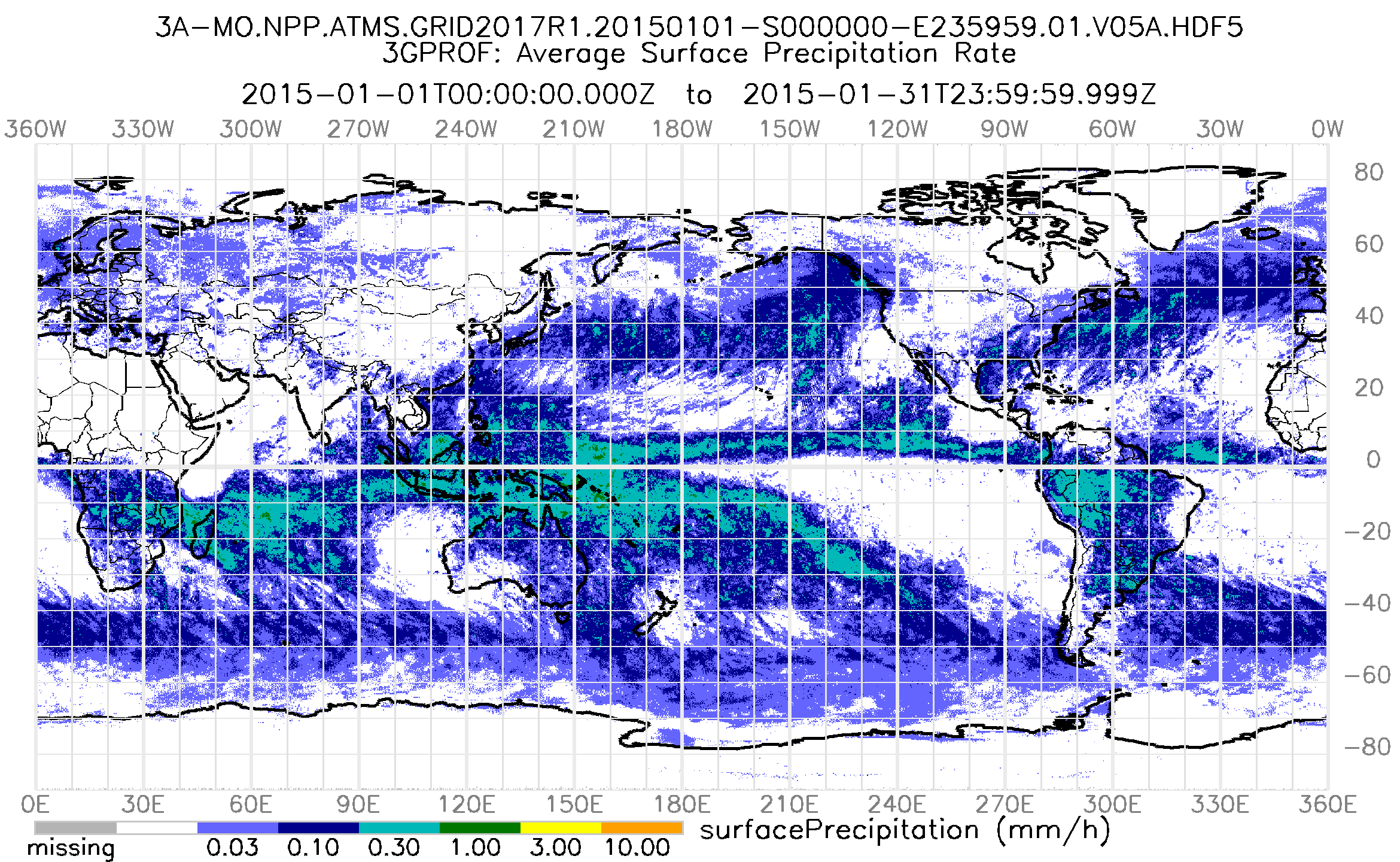
GPM ATMS on SUOMI-NPP (GPROF) Radiometer Precipitation Profiling L3 1 month 0.25 degree x 0.25 degree V07 (GPM_3GPROFNPPATMS) at GES DISC
National Aeronautics and Space Administration —
3GPROF products provide global gridded monthly/daily precipitation averages from multiple satellites that can be used for climate studies. The 3GPROF products are... -
Federal
GPM SSMIS on F17 (GPROF) Climate-based Radiometer Precipitation Profiling 1.5 hours 12 km V07 (GPM_2AGPROFF17SSMIS_CLIM) at GES DISC
National Aeronautics and Space Administration —
Version 07 is the current version of the data set. Older versions will no longer be available and have been superseded by Version 07.The 'CLIM' products differ from...

Official websites use .gov
A
.gov website belongs to an official government
organization in the United States.
Secure .gov websites use HTTPS
A
lock (
) or https:// means you’ve safely connected to
the .gov website. Share sensitive information only on official,
secure websites.