
-
Federal
GPM IMERG Final Precipitation L3 1 day 0.1 degree x 0.1 degree V07 (GPM_3IMERGDF) at GES DISC
National Aeronautics and Space Administration —
Version 07 is the current version of the data set. Older versions will no longer be available and have been superseded by Version 07.The Integrated Multi-satellitE... -
Federal
GLDAS Noah Land Surface Model L4 monthly 0.25 x 0.25 degree V2.1 (GLDAS_NOAH025_M) at GES DISC
National Aeronautics and Space Administration —
NASA Global Land Data Assimilation System Version 2 (GLDAS-2) has three components: GLDAS-2.0, GLDAS-2.1, and GLDAS-2.2. GLDAS-2.0 is forced entirely with the... -
Federal
GLDAS Catchment Land Surface Model L4 monthly 1.0 x 1.0 degree V2.0 (GLDAS_CLSM10_M) at GES DISC
National Aeronautics and Space Administration —
NASA Global Land Data Assimilation System Version 2 (GLDAS-2) has three components: GLDAS-2.0, GLDAS-2.1, and GLDAS-2.2. GLDAS-2.0 is forced entirely with the... -
Federal
GLDAS Noah Land Surface Model L4 3 hourly 0.25 x 0.25 degree V2.0 (GLDAS_NOAH025_3H) at GES DISC
National Aeronautics and Space Administration —
NASA Global Land Data Assimilation System Version 2 (GLDAS-2) has three components: GLDAS-2.0, GLDAS-2.1, and GLDAS-2.2. GLDAS-2.0 is forced entirely with the... -
Federal
NLDAS VIC Land Surface Model L4 Monthly Climatology 0.125 x 0.125 degree V2.0 (NLDAS_VIC0125_MC) at GES DISC
National Aeronautics and Space Administration —
This data set contains a series of land surface parameters simulated from the VIC land-surface model (LSM) for Phase 2 of the North American Land Data Assimilation... -
Federal
M2-SCREAM: 3d,3-Hourly,Instantaneous,Model-Level,Assimilation,Assimilated Constituent Fields,Replayed MERRA-2 Meteorological Fields
National Aeronautics and Space Administration —
The MERRA-2 Stratospheric Composition Reanalysis of Aura MLS (M2-SCREAM) products produced at NASA’s Global Modeling and Assimilation Office (GMAO) are generated by... -
Federal
Sentinel-6A Level 1B GNSS Radio Occultation Daily RINEX V1 (S6A_RO_1B_POD_RNX_) at GES DISC
National Aeronautics and Space Administration —
This dataset provides the L1B Global Navigation Satellite System (GNSS) Radio Occultation (RO) Precise Orbit Determination (POD) data generated by NASA JPL from... -
Federal
MLS/Aura Level 3 Monthly Binned Hydroxyl (OH) Mixing Ratio on Assorted Grids V005 (ML3MBOH) at GES DISC
National Aeronautics and Space Administration —
ML3MBOH is the EOS Aura Microwave Limb Sounder (MLS) monthly binned on various vertical grids product for hydroxyl (OH) derived from radiances measured by the THz... -
Federal
LIMS/Nimbus-7 Level 2 Vertical Profiles of O3, NO2, H2O, HNO3, Geopotential Height, and Temperature V006 (LIMSN7L2) at GES DISC
National Aeronautics and Space Administration —
The Limb Infrared Monitor of the Stratosphere (LIMS) version 6 Level-2 data product consists of daily, geolocated, vertical profiles of temperature, geopotential... -
Federal
SNPP VIIRS High Resolution Level 3 monthly aerosol data, 0.1x0.1 degree grid Version 001 (AER_DBDT_M10KM_L3_VIIRS_SNPP) at GES DISC
National Aeronautics and Space Administration —
This High-Resolution (0.1 x 0.1 degree) Level 3 monthly Aerosol Optical Depth (AOD) product is generated by combining two Visible Infrared Imaging Radiometer Suite... -
Federal
GLDAS Noah Land Surface Model L4 monthly 1.0 x 1.0 degree V2.0 (GLDAS_NOAH10_M) at GES DISC
National Aeronautics and Space Administration —
NASA Global Land Data Assimilation System Version 2 (GLDAS-2) has three components: GLDAS-2.0, GLDAS-2.1, and GLDAS-2.2. GLDAS-2.0 is forced entirely with the... -
Federal
GLDAS Catchment Land Surface Model L4 daily 0.25 x 0.25 degree V2.0 (GLDAS_CLSM025_D) at GES DISC
National Aeronautics and Space Administration —
NASA Global Land Data Assimilation System Version 2 (GLDAS-2) has three components: GLDAS-2.0, GLDAS-2.1, and GLDAS-2.2. GLDAS-2.0 is forced entirely with the... -
Federal
GLDAS Noah Land Surface Model L4 monthly 0.25 x 0.25 degree V2.0 (GLDAS_NOAH025_M) at GES DISC
National Aeronautics and Space Administration —
NASA Global Land Data Assimilation System Version 2 (GLDAS-2) has three components: GLDAS-2.0, GLDAS-2.1, and GLDAS-2.2. GLDAS-2.0 is forced entirely with the... -
Federal
GPM IMERG Late Precipitation L3 1 day 0.1 degree x 0.1 degree V07 (GPM_3IMERGDL) at GES DISC
National Aeronautics and Space Administration —
Version 07 is the current version of the data set. Older versions will no longer be available and have been superseded by Version 07.The Integrated Multi-satellitE... -
Federal
GLDAS Catchment Land Surface Model L4 monthly 1.0 x 1.0 degree V2.1 (GLDAS_CLSM10_M) at GES DISC
National Aeronautics and Space Administration —
NASA Global Land Data Assimilation System Version 2 (GLDAS-2) has three components: GLDAS-2.0, GLDAS-2.1, and GLDAS-2.2. GLDAS-2.0 is forced entirely with the... -
Federal
SBUV2/NOAA-11 Ozone (O3) Profile and Total Column Ozone 1 Month Zonal Mean L3 Global 5.0 degree Latitude Zones V1 (SBUV2N11L3zm) at GES DISC
National Aeronautics and Space Administration —
The Solar Backscattered Ultraviolet (SBUV) from NOAA-11 Level-3 monthly zonal mean (MZM) product (SBUV2N11L3zm) is derived from the Level-2 retrieved ozone profiles.... -
Federal
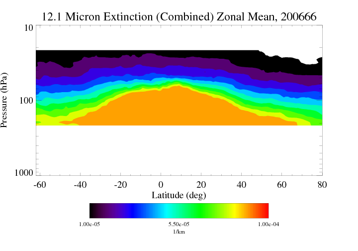
HIRDLS/Aura Level 3 Extinction at 12.1 Microns 1deg Lat Zonal Fourier Coefficients V007 (H3ZFC12MEXT) at GES DISC
National Aeronautics and Space Administration —
The "HIRDLS/Aura Level 3 Extinction at 12.1 Microns Zonal Fourier Coefficients" version 7 data product (H3ZFC12MEXT) contains the entire mission (~3 years) of HIRDLS... -
Federal
HIRS/Nimbus-6 Level 1 Calibrated Radiances for the Global Atmospheric Research Program (GARP) V001 (HIRSN6L1GARP) at GES DISC
National Aeronautics and Space Administration —
The Nimbus-6 High Resolution Infrared Radiometer (HIRS) Level 1 Calibrated Radiances for the Global Atmospheric Research Program (GARP) data product contains daily... -
Federal
HAQES 3-Hourly Ensemble mean surface total PM2.5 concentration at census level, North America V1 (HAQES_NA_PM25_TOT_CENSUS) at GES DISC
National Aeronautics and Space Administration —
This product provides HAQES 3-hourly ensemble mean surface total PM2.5 concentration at the census level over the continental United States (CONUS). The Hazardous Air... -
Federal
HIRDLS/Aura Level 3 Chlorine Nitrate (ClONO2) 1deg Lat Zonal Fourier Coefficients V007 (H3ZFCCLONO2) at GES DISC
National Aeronautics and Space Administration —
The "HIRDLS/Aura Level 3 Chlorine Nitrate (ClONO2) Zonal Fourier Coefficients" version 7 data product (H3ZFCCLONO2) contains the entire mission (~3 years) of HIRDLS...

Official websites use .gov
A
.gov website belongs to an official government
organization in the United States.
Secure .gov websites use HTTPS
A
lock (
) or https:// means you’ve safely connected to
the .gov website. Share sensitive information only on official,
secure websites.