
-
Federal
LBA-ECO CD-08 Radiocarbon Dates for Large Trees from a Forest near Manaus, Brazil
National Aeronautics and Space Administration —
This data set reports the ages and growth rates of trees as determined by radiocarbon dating (14C), selected from a logging operation near the city of Itacoatiara,... -
Federal
LBA-ECO CD-04 Soil Moisture Data, km 83 Tower Site, Tapajos National Forest, Brazil
National Aeronautics and Space Administration —
This data set reports continuous high-resolution frequency-domain reflectometry measurements of soil moisture to 10 m depth and precipitation data near each of the... -
Federal
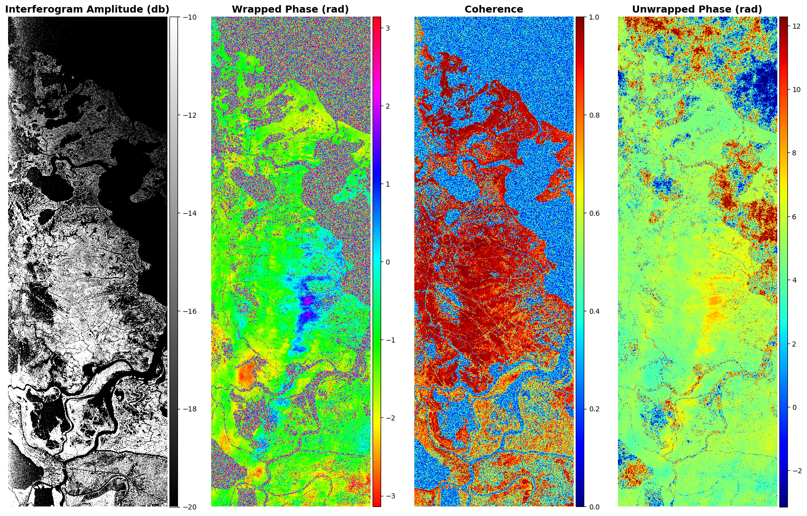
Delta-X: Delft3D Sediment Model, Site 294, Terrebonne Basin, MRD, Louisiana, USA
National Aeronautics and Space Administration —
This dataset contains the Delft3D model of the intensive site 294 in the Terrebonne Basin along the Mississippi River Delta (MRD) in coastal Louisiana. Simulations... -
Federal
S-NPP CrIS IMG_COL: Array indices for collocated VIIRS observations V2 (SNDRSNCrISL1BIMGC) at GES DISC
National Aeronautics and Space Administration —
The Cross-track Infrared Sounder (CrIS) Level 1B Normal Spectral Resolution (NSR) data files contain radiance measurements along with ancillary spacecraft,... -
Federal
Site Averaged Neutron Soil Moisture: 1987 (Betts)
National Aeronautics and Space Administration —
The Site Averaged Neutron Soil Moisture Data: 1987 (Betts) Data Set contains the site averaged product data of the neutron probe soil moisture collected during the... -
Federal
RSS CCMP Monthly 10 Meter Surface Winds Level 4 Version 3.1
National Aeronautics and Space Administration —
This data set contains a monthly-mean, 0.25 degree resolution, near-global gridded analysis of ocean surface winds (wind speed, components, and anomalies) from the... -
Federal
OMI/Aura Level 1B VIS Zoom-in Geolocated Earthshine Radiances V004 (OML1BRVZ) at GES DISC
National Aeronautics and Space Administration —
The Aura Ozone Monitoring Instrument (OMI) Level 1B (L1B) Zoom-in Earthshine UV Radiance, Zoom-mode (shortname OML1BRVZ) Version 4 product contains geolocated Earth... -
Federal
GPM AMSUB on NOAA16 (GPROF) Climate-based Radiometer Precipitation Profiling L3 1 day 0.25 degree x 0.25 degree V07 (GPM_3GPROFNOAA16AMSUB_DAY_CLIM) at GES DISC
National Aeronautics and Space Administration —
The "CLIM" products differ from their "regular" counterparts (without the "CLIM" in the name) by the ancillary data they use. They are Climate-Reference products,... -
Federal
GPM ATMS on NOAA-21 (GPROF) Climate-based Radiometer Precipitation Profiling L3 1 month 0.25 degree x 0.25 degree V07 (GPM_3GPROFNOAA21ATMS_CLIM) at GES DISC
National Aeronautics and Space Administration —
Version 07 is the current version of the data set. Older versions are no longer available and have been superseded by Version 07. The "CLIM" products differ from... -
Federal
BOREAS Follow-On DSP-10 Regridded Moss Cover Maps for 1994
National Aeronautics and Space Administration —
Existing 1-km moss cover classifications were reprocessed and are now available at multiple resolutions (2 km, 10x5 minutes, and 0.5 degree). These data were... -
Federal
AirMOSS: L1 S-0 Polarimetric Data from AirMOSS P-band SAR, MOISST, 2012-2015
National Aeronautics and Space Administration —
This data set provides level 1 (L1) polarimetric radar backscattering coefficient (sigma-0), multilook complex, polarimetrically calibrated, and georeferenced data... -
Federal
CERES and GEO-Enhanced TOA, Within-Atmosphere and Surface Fluxes, Clouds and Aerosols Daily Terra-NOAA20 Edition4A
National Aeronautics and Space Administration —
CER_SYN1deg-Day_Terra-NOAA20_Edition4A is the Clouds and the Earth's Radiant Energy System (CERES) and geostationary (GEO)-Enhanced Top-of-Atmosphere (TOA), Within-... -
Federal
CALIPSO Lidar Level 2 Vertical Feature Mask (VFM), V4-20
National Aeronautics and Space Administration —
CAL_LID_L2_VFM-Standard-V4-20 is the Cloud-Aerosol Lidar and Infrared Pathfinder Satellite Observations (CALIPSO) Lidar Level 2 Vertical Feature Mask (VFM), Version... -
Federal
BOREAS TE-18 Landsat TM Physical Classification Image of the NSA
National Aeronautics and Space Administration —
The objective of this classification is to provide the BOREAS investigators with a data product that characterizes the land cover of the NSA. A Landsat-5 TM image... -
Federal
Pre-LBA Rondonia Boundary Layer Experiment (RBLE) Data
National Aeronautics and Space Administration —
The atmospheric boundary layer (ABL) is the layer of air closest to the ground which is directly influenced on a daily basis by the heating and cooling of the earth's... -
Federal
GPM SSMI on F08 (GPROF) Climate-based Radiometer Precipitation Profiling L3 1 month 0.25 degree x 0.25 degree V07 (GPM_3GPROFF08SSMI_CLIM) at GES DISC
National Aeronautics and Space Administration —
Version 7 is the current version of the data set. Older versions will no longer be available and have been superseded by the current version. The "CLIM" products... -
Federal
BOREAS Level-3b AVHRR-LAC Imagery: Scaled At-Sensor Radiance in LGSOWG Format
National Aeronautics and Space Administration —
The BOREAS Staff Science Satellite Data Acquisition Program focused on providing the research teams with the remotely sensed satellite data products they needed to... -
Federal
TOVS GLA MONTHLY GRIDS from TIROS-N 02 (TOVSAMTN) at GES DISC
National Aeronautics and Space Administration —
This dataset (TOVSAMTN) contains the TIROS Operational Vertical Sounder (TOVS) level 3 geophysical parameters derived using data from TIROS-N and the physical... -
Federal
TROPESS Chemical Reanalysis HNO3 6-Hourly 3-dimensional Product V1 (TRPSCRHNO36H3D) at GES DISC
National Aeronautics and Space Administration —
The TROPESS Chemical Reanalysis HNO3 6-Hourly 3-dimensional Product contains vertical concentrations of nitric acid. The data are part of the Tropospheric Chemical...

Official websites use .gov
A
.gov website belongs to an official government
organization in the United States.
Secure .gov websites use HTTPS
A
lock (
) or https:// means you’ve safely connected to
the .gov website. Share sensitive information only on official,
secure websites.