

90,147 datasets found
-
State
Significant Anadromous Fish Habitat - ACE [ds2759] recent views
State of California —
For more information, see the Aquatic Significant Habitats Factsheet at https://nrm.dfg.ca.gov/FileHandler.ashx?DocumentID=150855.The California Department of Fish... -
State
Vegetation - Carnegie SVRA [ds2946] recent views
State of California —
Vegetation types in the study area were initially identified using information obtained from previous vegetation mapping efforts in the Carnegie SVRA (HDR 2004, Jones... -
State
Vegetation - Garrapata State Park [ds2945] recent views
State of California —
The study area for this project was Garrapata State Park in northwestern Monterey County, California. Development of Garrapata State Park land by Spanish missionaries... -
State
Wood Stork Range - CWHR B603 [ds1692] recent views
State of California —
Vector datasets of CWHR range maps are one component of California Wildlife Habitat Relationships (CWHR), a comprehensive information system and predictive model for... -
State
Resource Assessment Program Photos [ds205] recent views
State of California —
Contains a comprehensive listing of all spatially catalogued photographs collected during mobile habitat surveys by Program field staff. Current dataset is for... -
State
Axis Deer Range - CWHR M180 [ds1957] recent views
State of California —
Vector datasets of CWHR range maps are one component of California Wildlife Habitat Relationships (CWHR), a comprehensive information system and predictive model for... -
State
Quail Hunt Zones [ds1342] recent views
State of California —
Mapped hunt boundary is an approximation of regulations using best available data as of September 2015. Hunters are responsible for knowing the exact current boundary... -
University
Sept 2013 NFHL Flood Hazard Areas recent views
Earth Data Analysis Center, University of New Mexico —
The National Flood Hazard Layer (NFHL) data incorporates all Digital Flood Insurance Rate Map(DFIRM) databases published by FEMA, and any Letters Of Map Revision... -
University
Current 5-Digit ZIP Code Tabulation Areas (ZCTAs) for Chaves County, New Mexico, 2006se TIGER recent views
Earth Data Analysis Center, University of New Mexico —
The 2006 Second Edition TIGER/Line files are an extract of selected geographic and cartographic information from the Census TIGER database. The geographic coverage... -
Federal
H04373: NOS Hydrographic Survey recent views
National Oceanic and Atmospheric Administration, Department of Commerce —
The National Oceanic and Atmospheric Administration (NOAA) has the statutory mandate to collect hydrographic data in support of nautical chart compilation for safe... -
State
MD iMAP: Maryland Census Data - Census Tracts recent views
State of Maryland —
This is a MD iMAP hosted service. Find more information at http://imap.maryland.gov. The units of geography used for the 2010 Census maps displayed here are the... -
Federal
CDDIS SESES MEaSUREs products plate boundary aseismic transient deformation recent views
National Aeronautics and Space Administration —
Making Earth System Data Records for Use in Research Environments (MEaSUREs) empowers the research community to participate in developing and generating data products... -
University
NM Property Tax Districts November 2010 recent views
Earth Data Analysis Center, University of New Mexico —
This layer represents boundaries for New Mexico tax district "OUT" categories and incorporated/municipal "IN" categories as identified on the "Certificate of Tax... -
State
City Annual Financial Reports recent views
State of Iowa —
This resource provides annual financial reports for cities in Iowa starting in 2013. -
Federal
Partial pressure of carbon dioxide, temperature, salinity and other variables collected from surface underway observations during Ships of Opportunity (SOOP) M/V Celebrity Equinox cruise lines in the Caribbean Sea and North Atlantic Ocean in 2023 (NCEI Accession 0277172) recent views
National Oceanic and Atmospheric Administration, Department of Commerce —
This dataset consists of the surface underway measurements of mole fraction of CO2 in the equilibrator headspace (dry) at equilibrator temperature (ppm), mole... -
Federal
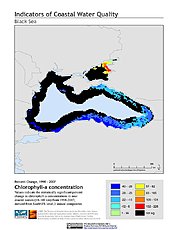
Indicators of Coastal Water Quality: Change in Chlorophyll-a Concentration 1998-2007 recent views
National Aeronautics and Space Administration —
The Change in Chlorophyll-a Concentrations 1998-2007 component of the Indicators of Coastal Water Quality Collection represents a tabular time series of the... -
State
Wood Duck Habitat Model for NSNF Connectivity - CDFW [ds1054] recent views
State of California —
The Maxent modeling algorithm was used to build the species distribution model at 270 m spatial resolution using species occurrence points and environmental layers as... -
State
Connecticut General Statutes recent views
State of Connecticut —
Online listing of the Connecticut General Statutes. -
Federal
Glacier Covered Area for the State of Alaska, 1985-2020, Version 1 recent views
National Aeronautics and Space Administration —
This data set captures changes in glacier covered area across the state of Alaska for the period 1985 to 2020.The data set includes 18 biannual shapefiles each for... -
Federal
Biological oxygen saturation (Î(O2/Ar)) collected from surface underway observations using EIMS from NOAA Ship Ronald H. Brown during the ECOA2022 project from 2022-08-06 to 2022-09-23 (NCEI Accession 0281870) recent views
National Oceanic and Atmospheric Administration, Department of Commerce —
This NCEI Accession contains the surface underway biological oxygen saturation data of the third dedicated East Coast Ocean Acidification cruise (ECOA2022). The...
90,147 datasets found