
-
Federal
LBA-ECO LC-04 Macrohydrological Routing Data for the Amazon and Tocantins River Basin
National Aeronautics and Space Administration —
This data set provides continental-scale hydrological river flow routing parameter data for the Amazon and Tocantins River basins at 5 minute (~9 km) resolution... -
Federal
LBA-ECO CD-10 Tree DBH Measurements at the km 67 Tower Site, Tapajos National Forest
National Aeronautics and Space Administration —
This data sets reports diameter at breast height (DBH) measurements in the old-growth upland forest at the Para Western (Santarem) - km 67, Primary Forest Tower Site.... -
Federal
LBA-ECO ND-01 Fractional Land Cover Images, Rondonia, Brazil: 1984-2000
National Aeronautics and Space Administration —
This data set provides fractional land cover type images for shade, green vegetation (GV), non-photosynthetic vegetation (NPV), and soil for the regions of JiParana,... -
Federal
LBA Regional Land Cover from AVHRR, 8-km, 1984 (DeFries et al.)
National Aeronautics and Space Administration —
This data set is a subset of an 8-km global land cover product (DeFries et al. 1998). This subset was created for the study area of the Large Scale Biosphere-... -
Federal
LBA-ECO CD-04 Soil Respiration, km 83 Tower Site, Tapajos National Forest, Brazil
National Aeronautics and Space Administration —
This data set reports on the flux of carbon dioxide from logged forest soils near the eddy flux tower at the km 83 site, Para, Brazil. The automated soil respiration... -
Federal
LBA-ECO CD-10 CO, CO2 and Meteorological Data, Maxaranguape, Brazil
National Aeronautics and Space Administration —
This data set reports the concentrations of carbon monoxide (CO) and carbon dioxide (CO2), wind direction, wind speed, and air temperature measured at the... -
Federal
ISLSCP II Global Gridded Soil Characteristics
National Aeronautics and Space Administration —
This data set provides gridded data for selected soil parameters derived from data and methods developed by the Global Soil Data Task, an international collaborative... -
Federal
ISLSCP II GlobalView: Atmospheric Methane Concentrations
National Aeronautics and Space Administration —
The GlobalView Methane (CH4) data product contains synchronized and smoothed time series of atmospheric CH4 concentrations at selected sites that were created using... -
Federal
SAFARI 2000 Canopy Structural Measurements, Kalahari Transect, Wet Season 2001
National Aeronautics and Space Administration —
This data set contains leaf area index (LAI), leaf inclination angle, and canopy dimension data from study sites along the Kalahari Transect in southwest Botswana.... -
Federal
PhenoCam Dataset v2.0: Digital Camera Imagery from the PhenoCam Network, 2000-2018
National Aeronautics and Space Administration —
This dataset provides a time series of visible-wavelength digital camera imagery collected through the PhenoCam Network at each of 393 sites predominantly in North... -
Federal
Walker Branch Watershed Vegetation Inventory, 1967-2006, R1
National Aeronautics and Space Administration —
This data set contains five data files, in comma-separated format (.csv), derived from the Walker Branch Watershed (WBW) vegetation inventory in eastern Tennessee.... -
Federal
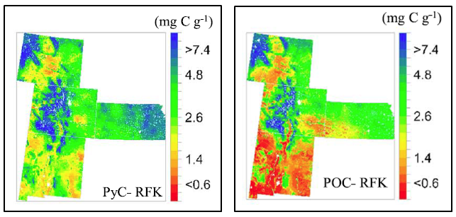
Stocks of Surface Soil Organic Carbon Fractions, Great Plains Region, USA, 2007-2010
National Aeronautics and Space Administration —
This dataset provides estimates of total organic soil carbon (SOC), pyrogenic (PyC), particulate (POC), and other organic soil carbon (OOC) fractions in 473 surface... -
Federal
SNF Site Characterization Data: C.Jarvis
National Aeronautics and Space Administration —
This data set documentation is currently in work. In the interim, an abstract of the entire Superior National Forest (SNF) data collection activity from which the SNF... -
Federal
Satellite SPOT Extracted Data (FIFE)
National Aeronautics and Space Administration —
The Site Reflectances Extracted from SPOT HRV Imagery Data Set contains the average instrument corrected spectral radiances for each of the spectral bands (3 in XS... -
Federal
RLC Forest Fire Images in Russia, 1998-1999
National Aeronautics and Space Administration —
This data set is made up of images of forest fires in Russia from NOAA's Operational Significant Event Imagery (OSEI) archive (http://www.osei.noaa.gov) for the 1998... -
Federal
NWS Daily Climatology Data: 1974 (SNF)
National Aeronautics and Space Administration —
Weather data were collected by the National Weather Service in International Falls, Minnesota. International Falls is about 80 miles from the SNF, but the weather... -
Federal
Gamma Ray Data: Peck (FIFE)
National Aeronautics and Space Administration —
Airborne soil moisture measurement is based on the difference between natural terrestrial gamma radiation flux measured for comparatively wet and dry soils. The...

Official websites use .gov
A
.gov website belongs to an official government
organization in the United States.
Secure .gov websites use HTTPS
A
lock (
) or https:// means you’ve safely connected to
the .gov website. Share sensitive information only on official,
secure websites.