
-
Federal
Map Layer: National Weather Services's Base Reflectivity Images (Doppler Radar)
National Oceanic and Atmospheric Administration, Department of Commerce —
The National Weather Service produces base reflectivity images from the network of Doppler radars. Taken from the lowest elevation (1/2 degree) slice, it is the... -
Federal
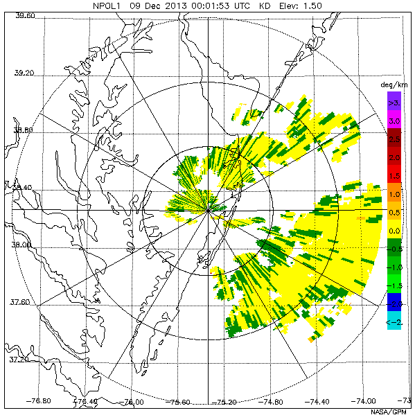
GPM Ground Validation NASA S-Band Dual Polarimetric (NPOL) Doppler Radar Wallops Flight Facility (WFF) V1
National Aeronautics and Space Administration —
The GPM Ground Validation NASA S-Band Dual-Polarimetric (NPOL) Doppler Radar Wallops Flight Facility (WFF) dataset consists of rain rate, reflectivity, Doppler... -
Federal
Currents, HFRadar, Monterey Bay, 1 hr, 2008-2009, EXPERIMENTAL, Lon+/-180
National Oceanic and Atmospheric Administration, Department of Commerce —
The data is the 1 hour average of the zonal component of ocean surface currents derived from High Frequency Radio-derived measurements. THIS IS AN EXPERIMENTAL... -
Federal
Currents, HFRadar, Bodega Bay, 25 hr, 2008-2009, EXPERIMENTAL
National Oceanic and Atmospheric Administration, Department of Commerce —
The data is the 25 hour running average of the zonal component of ocean surface currents derived from High Frequency Radio-derived measurements. THIS IS AN... -
Federal
Monthly Near-Surface Air Temperature Averages
National Aeronautics and Space Administration —
Global surface temperatures in 2010 tied 2005 as the warmest on record. The International Satellite Cloud Climatology Project (ISCCP) was established in 1982 as part... -
Federal
SnowEx23 Colorado State University Ground Penetrating Radar Raw V001
National Aeronautics and Space Administration —
This data set contains the raw results of 1 GHz ground-penetrating radar surveys conducted as part of the NASA SnowEx23 field campaign in Alaska, USA. Surveys were... -
Federal
SMAP L2 Radar/Radiometer Half-Orbit 9 km EASE-Grid Soil Moisture V003
National Aeronautics and Space Administration —
This Level-2 (L2) soil moisture product provides estimates of global land surface conditions retrieved by both the Soil Moisture Active Passive (SMAP) radar and... -
Federal
SMAP_L1B_SIGMA_NAUGHT_LOW_RES_METADATA_V002
National Aeronautics and Space Administration —
SMAP Level 1B Sigma Naught Low Res Product Metadata Version 2 -
Federal
TRMM Ground Validation Radar Reflectivity L1B 1 hour V7 (TRMM_1B51) at GES DISC
National Aeronautics and Space Administration —
The TRMM_1B51 product displays the existence of rain in the radar volume scan. 'Existence' is the fraction of the radar FOV which has measurable precipitation. The GV... -
Federal
PDS Cassini Data Release 20
National Aeronautics and Space Administration —
HRD, ISS, RADAR, RPWS, RSS, SPICE, UVIS, VIMS -
Federal
Radar - NOAA 915 MHz Boundary-Layer Wind Profiler - Raw Data
Department of Energy —
Overview Monitor real-time profiles of virtual temperature (C), wind speed (ms-1), and direction (deg) few km above ground level. Data Details Raw files contain... -
Federal
SMAP_L1C_SIGMA_NAUGHT_HIGH_RES_V002
National Aeronautics and Space Administration —
SMAP Level 1C Sigma Naught High Res Product Version 2 -
Federal
Radar - ESRL Wind Profiler with RASS, Wasco Airport - Derived Data
Department of Energy —
Overview Profiles of turbulence dissipation rate for 15-minute intervals, time-stamped at the beginning of the 15-minute period, during the final 30 minutes of each... -
Federal
SMAP L3 Radar/Radiometer Global Daily 9 km EASE-Grid Soil Moisture V003
National Aeronautics and Space Administration —
This Level-3 (L3) soil moisture product provides a daily composite of global land surface conditions retrieved by both the Soil Moisture Active Passive (SMAP) radar... -
Federal
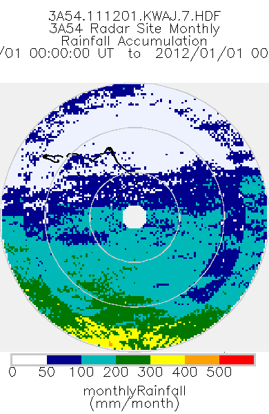
TRMM Ground Validation Radar Site Rain Type Totals Map L3 1 month 2 km V7 (TRMM_3A54) at GES DISC
National Aeronautics and Space Administration —
The 3A54 product, 'Site Rainfall Map', is a map of monthly surface rain totals derived from the instantaneous rain rate maps (2A53). The map is in Cartesian... -
Federal
Gazetteer of Planetary Nomenclature: Venus: 1:10 million-scale Altimetry Quadrangles: Niobe
National Aeronautics and Space Administration —
This set of maps diplays altimetric radar images of Venus approved by the International Astronomical Union (IAU). -
Federal
SMAPVEX08 PALS Backscatter Data V001
National Aeronautics and Space Administration —
This data set contains backscatter data obtained by the Passive Active L-band System (PALS) microwave aircraft radar instrument as part of the Soil Moisture Active... -
Federal
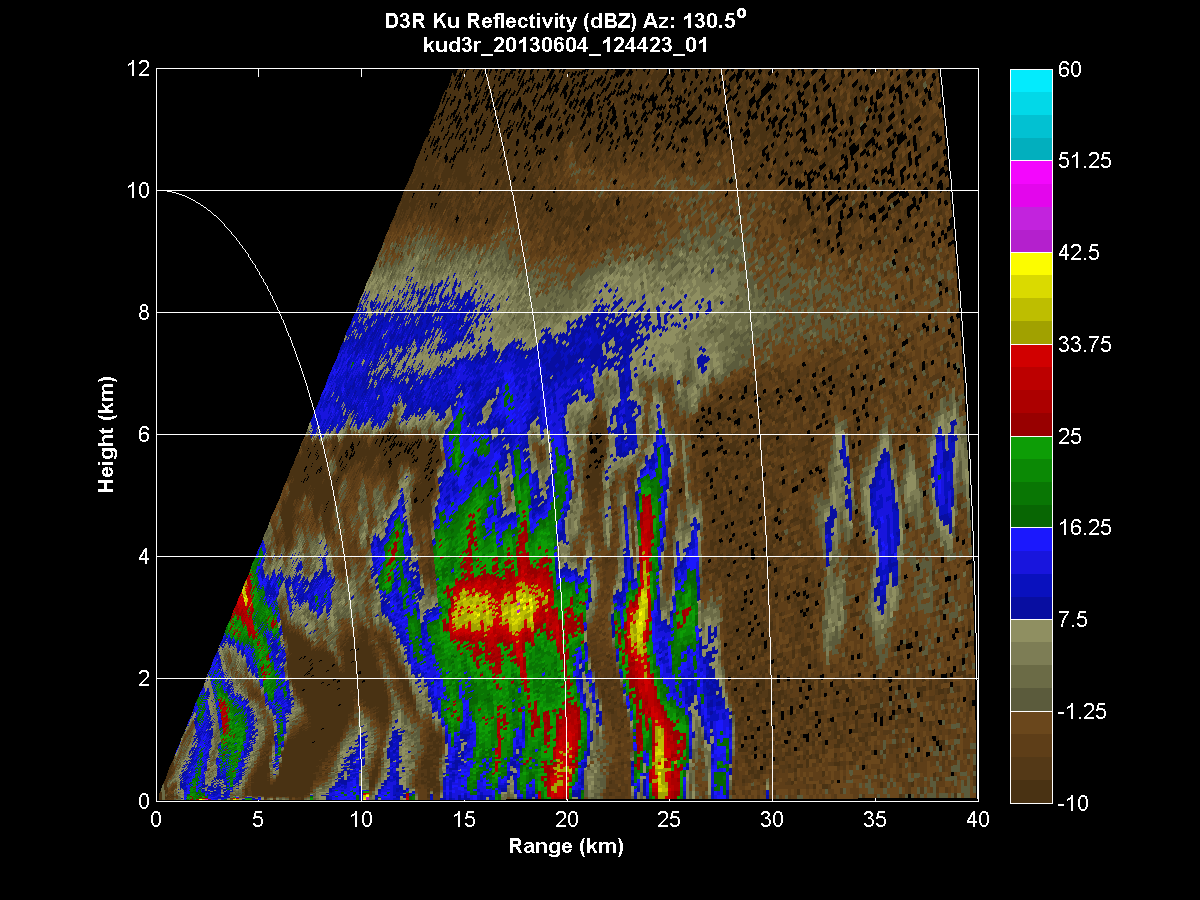
GPM GROUND VALIDATION DUAL-FREQUENCY DUAL-POLARIZED DOPPLER RADAR (D3R) IFLOODS V1
National Aeronautics and Space Administration —
The GPM Ground Validation Dual-frequency Dual-polarized Doppler Radar (D3R) IFloodS dataset contains radar reflectivity and doppler velocity measurements from the... -
Federal
TRMM Ground Validation Radar Site 3D Reflectivity L2 1 hour V7 (TRMM_2A55UW) at GES DISC
National Aeronautics and Space Administration —
This dataset is part of the University of Washington TRMM Ground Validation products. Multiple-level cartesian grid containing output of NCAR SPRINT interpolation of... -
Federal
SnowEx20-21 Cameron Pass Derived Snowpack Relative Permittivities and Densities from Ground Penetrating Radar V001
National Aeronautics and Space Administration —
This data set contains the results of ground-penetrating radar surveys conducted at Cameron Pass, Colorado during the SnowEx20 campaign. Data include two-way travel...

Official websites use .gov
A
.gov website belongs to an official government
organization in the United States.
Secure .gov websites use HTTPS
A
lock (
) or https:// means you’ve safely connected to
the .gov website. Share sensitive information only on official,
secure websites.