

172 datasets found for "Agriculture"
-
Federal
ECOSTRESS Gridded Downscaled Soil Moisture Instantaneous L3 Global 70 m V002
National Aeronautics and Space Administration —
The ECOsystem Spaceborne Thermal Radiometer Experiment on Space Station (ECOSTRESS) mission measures the temperature of plants to better understand how much water... -
Federal
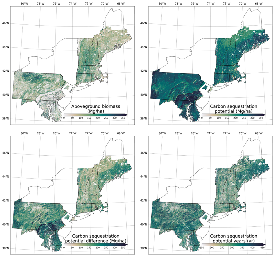
Forest Aboveground Biomass and Carbon Sequestration Potential, Northeastern USA
National Aeronautics and Space Administration —
This dataset provides 90 m estimates of forest aboveground biomass (Mg/ha) for nominal 2011 and projections of carbon sequestration potential for 11 states in the... -
Federal
Eddy Corr. Surface Flux: UNL (FIFE)
National Aeronautics and Space Administration —
Surface flux and micrometeorological measurements were collected at one site within the northwest quadrant near the center of the FIFE study area during all five of... -
Federal
AfriSAR: Aboveground Biomass for Lope, Mabounie, Mondah, and Rabi Sites, Gabon
National Aeronautics and Space Administration —
This dataset provides gridded estimates of aboveground biomass (AGB) for four sites in Gabon at 0.25 ha (50 m) resolution derived with field measurements and airborne... -
Federal
Annual wildland fire emissions (WFEIS v0.5) for Conterminous US and Alaska, 2001-2013
National Aeronautics and Space Administration —
This data set contains annual modeled estimates of wildland fire emissions at 0.01 degree (~1-km) spatial resolution from the Wildland Fire Emissions Information... -
Federal
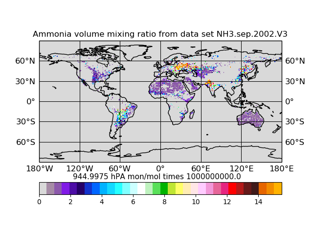
Atmospheric Composition Ammonia Volume Mixing Ratio L3 (AIRSAC3MNH3 V3) from AIRS/AMSU on NASA Aqua at GES DISC
National Aeronautics and Space Administration —
The mass concentration ammonia in the atmosphere, consists of products generated for the study of atmospheric ammonia. Atmospheric ammonia is an important component... -
Federal
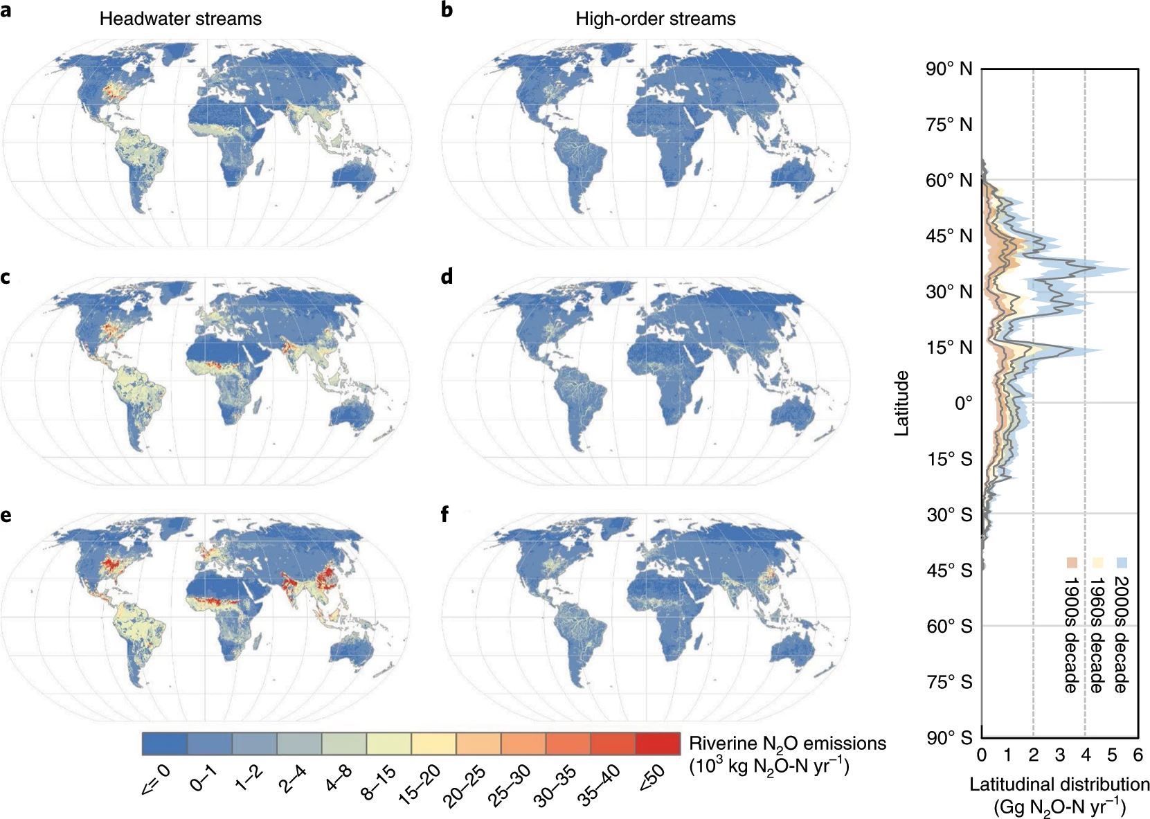
CMS: Annual Estimates of Global Riverine Nitrous Oxide Emissions, 1900-2016
National Aeronautics and Space Administration —
This dataset provides modeled estimates of annual nitrous oxide (N2O) emissions at a coarse geographic scale (0.5 x 0.5 degree) for two sets of global rivers and... -
Federal
BOREAS TGB-07 Ambient Air Herbicide and Organochlorine Concentration Data
National Aeronautics and Space Administration —
The BOREAS TGB-07 team measured the concentration and flux of several agricultural pesticides in air, rainwater, and dry deposition samples in order to determine the... -
Federal
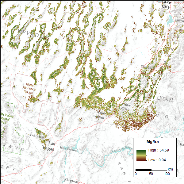
CMS: Pinyon-Juniper Forest Live Aboveground Biomass, Great Basin, USA, 2000-2016
National Aeronautics and Space Administration —
This dataset provides annual maps of live aboveground tree biomass (Mg/ha) for pinyon-juniper forests across the Great Basin of the Western USA for the years... -
Federal
SAFARI 2000 Land Cover from AVHRR, 8-km, 1984 (DeFries et al.)
National Aeronautics and Space Administration —
This data set consists of a southern African subset of the University of Maryland (UMD) 8-km Global Land Cover product in ASCII GRID and binary image files formats.... -
Federal
NASMo-TiAM 250m 16-day North America Surface Soil Moisture Dataset
National Aeronautics and Space Administration —
This NASMo-TiAM (North America Soil Moisture Dataset Derived from Time-Specific Adaptable Machine Learning Models) dataset holds gridded estimates of surface soil... -
Federal
LBA-ECO CD-05 Forest Understory Fuel Loads, Paragominas, Para, Brazil: 2001
National Aeronautics and Space Administration —
This data set contains estimates of understory fuel loads (forest litter) at six locations near Paragominas in Northeastern Amazonia. Samples were collected from...
172 datasets found for "Agriculture"