
-
Federal
Arctic Ice Dynamics Joint Experiment (AIDJEX) Second Pilot Study, March - May 1972: Still Images, Version 1
National Aeronautics and Space Administration —
This data set contains photographs of camps on drifting sea ice from the early 1970s along with a few aerial photographs of the drifting ice station T-3. Most of the... -
Federal
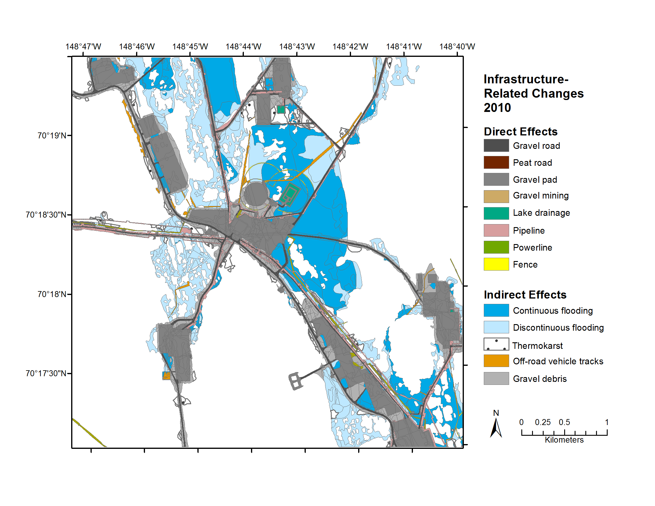
Geobotanical and Impact Map Collection for Prudhoe Bay Oilfield, Alaska, 1972-2010
National Aeronautics and Space Administration —
This data set provides a collection of maps of geoecological characteristics of areas within the Beechey Point quadrangle near Prudhoe Bay on the North slope of... -
Federal
SeaFlux Data Products V1
National Aeronautics and Space Administration —
The SeaFlux Data Products dataset consists of estimates of ocean surface latent and sensible heat fluxes, 2m and 10m wind speed, 2m and 10m air temperature, 2m and... -
Federal
Artic Network of Centres of Excellence of Canada
National Aeronautics and Space Administration —
Measurements taken in Hudson Bay on board the icebreaker C.C.G.S. Amundsen to gain knowledge on marine coastal ecosystems as part of the ArcticNet program in 2005 and... -
Federal
ARCTAS Supplementary Satellite Data Products
National Aeronautics and Space Administration —
ARCTAS_Satellite_Data is the supplementary satellite data for the Arctic Research of the Composition of the Troposphere from Aircraft & Satellites sub-orbital... -
Federal
ECCO Ocean Mixed Layer Depth - Monthly Mean 0.5 Degree (Version 4 Release 4)
National Aeronautics and Space Administration —
This dataset contains monthly-averaged ocean mixed layer depth interpolated to a regular 0.5-degree grid from the ECCO Version 4 revision 4 (V4r4) ocean and sea-ice... -
Federal
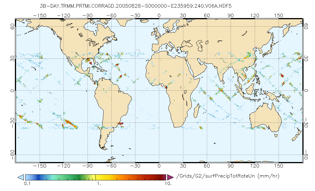
GPM PR and TMI on TRMM (Combined Precipitation) L3 1 day 0.25x0.25 degree V07 (GPM_3CMB_TRMM_DAY) at GES DISC
National Aeronautics and Space Administration —
This a new (GPM-formated) TRMM product, for the TRMM epoch (December 1997 - April 2015), created using GPM Algorithms. There is no equivalent in the old TRMM suite of... -
Federal
PEM Tropics B DC-8 Remotely Sensed Data
National Aeronautics and Space Administration —
PEM-Tropics-B_AircraftRemoteSensing_DC8_Data is the remote sensing data collected onboard the DC-8 aircraft during the Pacific Exploratory Mission (PEM) Tropics B... -
Federal
MAPSS: Mapped Atmosphere-Plant-Soil System Model, Version 1.0
National Aeronautics and Space Administration —
MAPSS (Mapped Atmosphere-Plant-Soil System) is a landscape to global vegetation distribution model that was developed to simulate the potential biosphere impacts and... -
Federal
VIIRS/JPSS1 BRDF/Albedo BSA at Solar Noon Band M11 Daily L3 Global 30ArcSec CMG V002
National Aeronautics and Space Administration —
The NOAA-20 Visible Infrared Imaging Radiometer Suite (VIIRS) Bidirectional Reflectance Distribution Function (BRDF) and Albedo Black-Sky Albedo for Band M11... -
Federal
NWS Daily Climatology Data: 1984 (SNF)
National Aeronautics and Space Administration —
Weather data were collected by the National Weather Service in International Falls, Minnesota. International Falls is about 80 miles from the SNF, but the weather... -
Federal
MODIS/Terra Vegetation Indices Monthly L3 Global 1km SIN Grid V006
National Aeronautics and Space Administration —
The MOD13A3 Version 6 data product was decommissioned on July 31, 2023. Users are encouraged to use the MOD13A3... -
Federal
VIIRS/NPP BRDF/Albedo BSA at Solar Noon Band M3 Daily L3 Global 30ArcSec CMG V001
National Aeronautics and Space Administration —
The VNP43D56 Version 1 data product was decommissioned on July 31, 2025. Users are encouraged to use theFederalVIIRS/NPP BRDF/Albedo BSA at Solar Noon DNB Daily L3 Global 30ArcSec CMG V001
National Aeronautics and Space Administration —
The VNP43D66 Version 1 data product was decommissioned on July 31, 2025. Users are encouraged to use theFederalVEMAP 1: U.S. Climate Change Scenarios Based on Models with Increased CO2
National Aeronautics and Space Administration —
The Vegetation/Ecosystem Modeling and Analysis Project (VEMAP) is an ongoing multiinstitutional, international effort addressing the response of biogeography and...FederalVIIRS/NPP BRDF/Albedo WSA at Solar Noon DNB Daily L3 Global 30ArcSec CMG V002
National Aeronautics and Space Administration —
The NASA/NOAA Suomi National Polar-orbiting Partnership (Suomi NPP) Visible Infrared Imaging Radiometer Suite (VIIRS) Bidirectional Reflectance Distribution Function...FederalTellus Level-4 Ocean Mass Anomaly Time Series from JPL GRACE/GRACE-FO Mascon CRI Filtered Release 06.3 version 04
National Aeronautics and Space Administration —
This dataset is a time series of mass variability averaged over all of the global ocean. It provides the non-steric or mass only sea level changes over time. The mass...FederalNPP Boreal Forest: Superior National Forest, USA, 1983-1984, R1
National Aeronautics and Space Administration —
This data set contains two files (.txt format). One file provides ground-based biophysical measurements and above-ground net primary productivity (ANPP) estimates for...1,908 datasets found for "climate"

Official websites use .gov
A
.gov website belongs to an official government
organization in the United States.
Secure .gov websites use HTTPS
A
lock (
) or https:// means you’ve safely connected to
the .gov website. Share sensitive information only on official,
secure websites.