
-
Federal
VIIRS/JPSS1 BRDF/Albedo Parameter 1 NIR Daily L3 Global 30 ArcSec CMG V002
National Aeronautics and Space Administration —
The NOAA-20 Visible Infrared Imaging Radiometer Suite (VIIRS) Bidirectional Reflectance Distribution Function (BRDF) and Albedo Model Parameter 1 NIR product... -
Federal
VIIRS/JPSS1 BRDF/Albedo Parameter 2 Band M7 Daily L3 Global 30 ArcSec CMG V002
National Aeronautics and Space Administration —
The NOAA-20 Visible Infrared Imaging Radiometer Suite (VIIRS) Bidirectional Reflectance Distribution Function (BRDF) and Albedo Model Parameter 2 Band M7 product... -
Federal
Aquarius Official Release Level 3 Ancillary Reynolds Sea Surface Temperature Standard Mapped Image Ascending Seasonal Data V5.0
National Aeronautics and Space Administration —
Aquarius Level 3 ancillary sea surface temperature (SST) standard mapped image data are the ancillary SST data used in the Aquarius calibration for salinity... -
Federal
Images of Antarctic Ice Shelves, Version 2
National Aeronautics and Space Administration —
Images of Antarctic Ice Shelves is a data set created as part of an effort to closely monitor major ice streams and outlet glaciers along the Antarctic coast, with a... -
Federal
INTEX-A Aircraft data
National Aeronautics and Space Administration —
INTEXA_DC8_AIRCRAFT is the Intercontinental Chemical Transport Experiment - North America Phase A (INTEX-A) Aircraft data product. INTEX-A was an integrated... -
Federal
AVISO Level 4 Absolute Dynamic Topography for Climate Model Comparison Standard Error
National Aeronautics and Space Administration —
These data are the standard error calculated from the AVISO Level 4 Absolute Dynamic Topography for Climate Model Comparison Number of Observations data set ( in... -
Federal
MODIS/Terra+Aqua BRDF/Albedo Nadir BRDF-Adjusted Ref Band5 Daily L3 Global 30ArcSec CMG V006
National Aeronautics and Space Administration —
The MCD43D66 Version 6 data product was decommissioned on July 31, 2023. Users are encouraged to use the MCD43D66... -
Federal
MODIS/Terra+Aqua BRDF/Albedo Black Sky Albedo NIR Daily L3 Global 30ArcSec CMG V006
National Aeronautics and Space Administration —
The MCD43D50 Version 6 data product was decommissioned on July 31, 2023. Users are encouraged to use the MCD43D50... -
Federal
GPM SSMIS on F16 (GPROF) Radiometer Precipitation Profiling L3 1 month 0.25 degree x 0.25 degree V07 (GPM_3GPROFF16SSMIS) at GES DISC
National Aeronautics and Space Administration —
Version 07 is the current version of the data set. Older versions will no longer be available and have been superseded by Version 07. 3GPROF products provide global... -
Federal
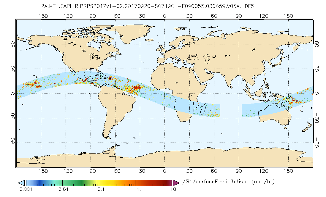
GPM SAPHIR on MT1 (PRPS) Climate-based Radiometer Precipitation Profiling L2 1.5 hours 10 km V06 (GPM_2APRPSMT1SAPHIR_CLIM) at GES DISC
National Aeronautics and Space Administration —
Version 6 is the current version of this dataset. Older versions are no longer available and have been superseded by Version 6. The Precipitation Retrieval and... -
Federal
MODIS/Terra+Aqua BRDF/Albedo Nadir BRDF-Adjusted Ref Band5 Daily L3 Global 30ArcSec CMG V061
National Aeronautics and Space Administration —
The MCD43D66 Version 6.1 Bidirectional Reflectance Distribution Function and Albedo (BRDF/Albedo) Nadir BRDF-Adjusted Reflectance (NBAR) dataset is produced daily... -
Federal
MODIS/Terra+Aqua BRDF/Albedo Parameter1 VIS Daily L3 Global 30ArcSec CMG V061
National Aeronautics and Space Administration —
The MCD43D22 Version 6.1 Bidirectional Reflectance Distribution Function and Albedo (BRDF/Albedo) Model Parameter dataset is produced daily using 16 days of Terra and... -
Federal
TOLNet NOAA Chemical Sciences Laboratory Data
National Aeronautics and Space Administration —
TOLNet_CSL_Data is the lidar data collected by the Tunable Optical Profile for Aerosol and oZone (TOPAZ) lidar at the NOAA Chemical Sciences Laboratory (CSL) in... -
Federal
ATom: Development of Cloud Indicator Algorithm Using Airborne Observations from CAPS
National Aeronautics and Space Administration —
This dataset is the basis for the development of the Cloud Indicator, a novel algorithm that automatically detects and classifies measurement periods inside clouds.... -
Federal
GPM SSMI on F10 (GPROF) Climate-based Radiometer Precipitation Profiling L3 1 month 0.25 degree x 0.25 degree V07 (GPM_3GPROFF10SSMI_CLIM) at GES DISC
National Aeronautics and Space Administration —
Version 7 is the current version of the data set. Older versions will no longer be available and have been superseded by the current version. The "CLIM" products... -
Federal
INTEX-B Ozonesonde data
National Aeronautics and Space Administration —
INTEX-NA is a two phase experiment that aims to understand the transport and transformation of gases and aerosols on transcontinental/intercontinental scales and... -
Federal
VIIRS/NPP BRDF/Albedo WSA at Solar Noon Band M8 Daily L3 Global 30ArcSec CMG V001
National Aeronautics and Space Administration —
The VNP43D73 Version 1 data product was decommissioned on July 31, 2025. Users are encouraged to use theFederalMODIS/Terra+Aqua BRDF/Albedo Parameter1 Shortwave Daily L3 Global 30ArcSec CMG V061
National Aeronautics and Space Administration —
The MCD43D28 Version 6.1 Bidirectional Reflectance Distribution Function and Albedo (BRDF/Albedo) Model Parameter dataset is produced daily using 16 days of Terra and...FederalINTEX-B Ground data
National Aeronautics and Space Administration —
INTEX-NA is a two phase experiment that aims to understand the transport and transformation of gases and aerosols on transcontinental/intercontinental scales and...FederalMODIS/Terra+Aqua BRDF/Albedo QA ValidobsBand1 Daily L3 Global 30ArcSec CMG V061
National Aeronautics and Space Administration —
The MCD43D33 Version 6.1 Bidirectional Reflectance Distribution Function and Albedo (BRDF/Albedo) QA ValidObs Band 1 dataset is produced daily using 16 days of Terra...1,908 datasets found for "climate"

Official websites use .gov
A
.gov website belongs to an official government
organization in the United States.
Secure .gov websites use HTTPS
A
lock (
) or https:// means you’ve safely connected to
the .gov website. Share sensitive information only on official,
secure websites.