
-
Federal
AFSC/RACE/GAP/McConnaughey: Fishpac Projects-2008-FFCPT
National Oceanic and Atmospheric Administration, Department of Commerce —
The broad scope of the Essential Fish Habitat (EFH) mandate requires an efficient process for describing and mapping the habitat needs of federally managed species.... -
Federal
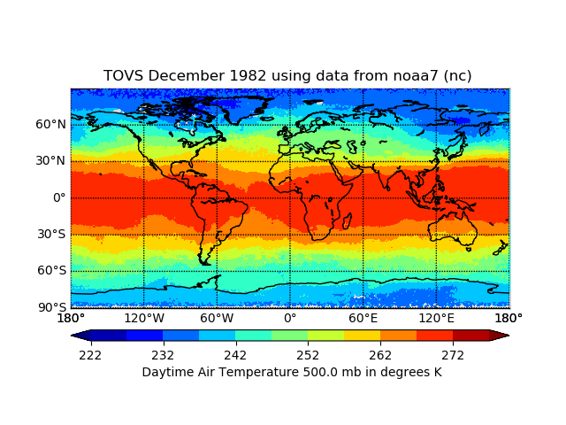
TOVS GLA MONTHLY GRIDS from NOAA-7 02 (TOVSAMNC) at GES DISC
National Aeronautics and Space Administration —
This dataset (TOVSAMNC) contains the TIROS Operational Vertical Sounder (TOVS) level 3 geophysical parameters derived using data from NOAA-7 and the physical... -
Federal
Hyperspectral Imagery for the Main Eight Hawaiian Islands:Oahu (207b-0613-332211)
National Oceanic and Atmospheric Administration, Department of Commerce —
This project is a cooperative effort among the National Ocean Service, National Centers for Coastal Ocean Science, Center for Coastal Monitoring and Assessment; the... -
Federal
VIIRS/NPP BRDF/Albedo Albedo Daily L3 Global 1km SIN Grid V001
National Aeronautics and Space Administration —
The VNP43MA3 Version 1 data product was decommissioned on July 31, 2025. Users are encouraged to use theFederalNorthwest Peninsular Florida 2016 ESI PARKS-MANAGED AREAS Polygons
National Oceanic and Atmospheric Administration, Department of Commerce —
This data set contains vector polygons depicting locations for management areas, military areas, national parks, Nature Conservancy lands, state or regional parks,...FederalNITRD Program Supplement to the President`s Budget - FY 2020
Networking and Information Technology Research and Development, Executive Office of the President —
This document is a supplement to the Presidents 2020 Budget Request to Congress. It describes research and development coordination activities planned for...FederalSensitivity of Coastal Environments and Wildlife to Spilled Oil: Central California: MGT (Management Area Polygons)
National Oceanic and Atmospheric Administration, Department of Commerce —
This data set contains boundaries of Coast Guard facilities; management areas; marinas; marine sanctuaries; national forests; national, regional, and state parks;...FederalAlabama ESI: REPTILES (Reptile Polygons)
National Oceanic and Atmospheric Administration, Department of Commerce —
This data set contains sensitive biological resource data for threatened/endangered and rare reptiles in Alabama. Vector polygons in this data set represent the rare...FederalMaine and New Hampshire 2016 T_MAMMAL (Terrestrial Mammal Polygons)
National Oceanic and Atmospheric Administration, Department of Commerce —
This data set contains sensitive biological resource data for terrestrial mammals in Maine and New Hampshire. Vector polygons in this data set represent known...FederalForest Aboveground Biomass and Carbon Sequestration Potential for Maryland, USA.
National Aeronautics and Space Administration —
This dataset provides 90-m resolution maps of estimated forest aboveground biomass (Mg/ha) for nominal year 2011 and projections of carbon sequestration potential for...FederalBristol Bay, Alaska Subarea ESI: ESI (Environmental Sensitivity Index Shoreline Types - Lines and Polygons)
National Oceanic and Atmospheric Administration, Department of Commerce —
This data set contains vector lines and polygons representing the shoreline and coastal habitats of the Bristol Bay Subarea, classified according to the Environmental...FederalNorthwest Peninsular Florida 2016 ESI INVERTEBRATE Polygons, Points
National Oceanic and Atmospheric Administration, Department of Commerce —
This data set contains sensitive biological resource data for marine, estuarine, and freshwater invertebrates, and federally and/or state endangered, threatened, or...FederalAlabama ESI: T_MAMMAL (Terrestrial Mammal Polygons)
National Oceanic and Atmospheric Administration, Department of Commerce —
This data set contains sensitive biological resource data for Alabama and Perdido Key beach mice in Alabama. Vector polygons in this data set represent the rare...FederalSensitivity of Coastal Environments and Wildlife to Spilled Oil: Southern California: INDEX (Index Polygons)
National Oceanic and Atmospheric Administration, Department of Commerce —
This data set contains vector polygons representing the boundaries of all hardcopy cartographic products and digital data extents produced as part of the...FederalLessons Learned from Federal Use of Cloud Computing To Support Artificial Intelligence Research and Development
Networking and Information Technology Research and Development, Executive Office of the President —
This document aims to capture lessons learned from the activities spearheaded by various agencies to enhance access to cloud computing resources to advance federally...FederalMassachusetts and Rhode Island 2016 NAV_MARINE_POINT (Navigational/Marine - Recreational/Maritime Points)
National Oceanic and Atmospheric Administration, Department of Commerce —
This data set contains vector points depicting locations for navigation/marine sites for Massachusetts, Rhode Island. Navigation/marine sites in this atlas include...FederalSensitivity of Coastal Environments and Wildlife to Spilled Oil: Central California: T_MAMMAL (Terrestrial Mammal Polygons)
National Oceanic and Atmospheric Administration, Department of Commerce —
This data set contains sensitive biological resource data for rare/sensitive species occurrences of terrestrial mammals in Central California. Vector polygons in this...FederalMassachusetts and Rhode Island 2016 T_MAMMAL (T_Mammal Polygons)
National Oceanic and Atmospheric Administration, Department of Commerce —
This data set contains sensitive biological resource data for terrestrial mammals in Massachusetts and Rhode Island. Vector polygons in this data set represent known...FederalSouth Carolina 2015 ESI Lines
National Oceanic and Atmospheric Administration, Department of Commerce —
This data set contains vector lines representing the ESI classified shoreline of South Carolina classified according to the Environmental Sensitivity Index (ESI)...FederalVirginia ESI: HABITATS (Habitat Polygons)
National Oceanic and Atmospheric Administration, Department of Commerce —
This data set contains sensitive biological resource data for submerged aquatic vegetation (SAV) and rare terrestrial plants/communities in Virginia. Vector polygons...1,700 datasets found for "computer science"

Official websites use .gov
A
.gov website belongs to an official government
organization in the United States.
Secure .gov websites use HTTPS
A
lock (
) or https:// means you’ve safely connected to
the .gov website. Share sensitive information only on official,
secure websites.