
-
Federal
GPM GMI (GPROF) Climate-based Radiometer Precipitation Profiling L3 1 day 0.25 degree x 0.25 degree V07 (GPM_3GPROFGPMGMI_DAY_CLIM) at GES DISC
National Aeronautics and Space Administration —
Version 07 is the current version of the data set. Older versions will no longer be available and have been superseded by Version 07.The "CLIM" products differ from... -
Federal
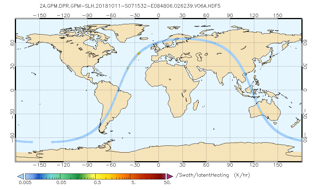
GPM DPR Spectral Latent Heating Profiles L2 1.5 hours 5 km V07 (GPM_2HSLH) at GES DISC
National Aeronautics and Space Administration —
Version 6B of these data were introduced in July, 2020. Please, see documentation tab for release notes. Latent heating variables are retrieved utilizing two separate... -
Federal
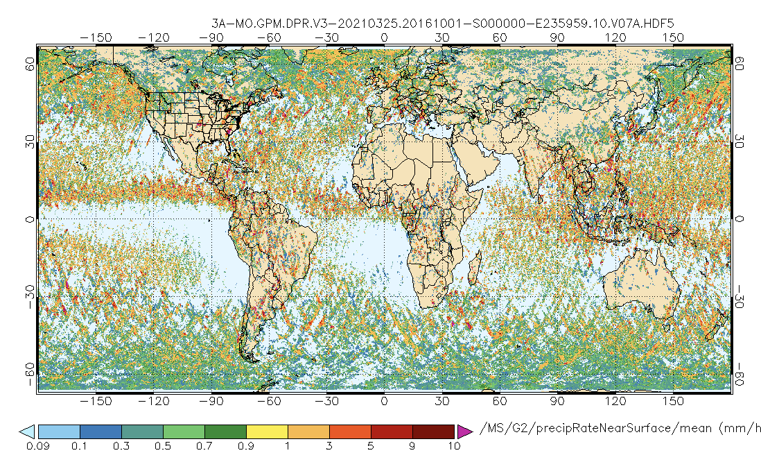
GPM DPR Precipitation Profile 1 month 0.25 degree x 0.25 degree V07 (GPM_3DPR) at GES DISC
National Aeronautics and Space Administration —
Version 07 is the current version of the data set. Older versions will no longer be available and have been superseded by Version 07.. The Level 3 DPR products... -
Federal
GPM DPR Spectral Latent Heating Profiles L3 1 month 0.5 degree x 0.5 degree V07 (GPM_3HSLH) at GES DISC
National Aeronautics and Space Administration —
Version 07 is the current version of the data set. Older versions will no longer be available and have been superseded by Version 07.The Gridded Spectral Latent... -
Federal
GPM DPR Ku Precipitation Profile 2A 1.5 hours 5 km V07 (GPM_2AKu) at GES DISC
National Aeronautics and Space Administration —
Version 07 is the current version of the data set. Older versions will no longer be available and have been superseded by Version 07. The 2AKu algorithm is a single-... -
Federal
Global Navigation Satellite System (GNSS) IGS Final Combined Satellite and Receiver Clock Solution (5 minute resolution, daily files, generated weekly) product from NASA CDDIS
National Aeronautics and Space Administration —
This derived product set consists of Global Navigation Satellite System Final Satellite and Receiver Clock Product (5-minute granularity, daily files, generated... -
Federal
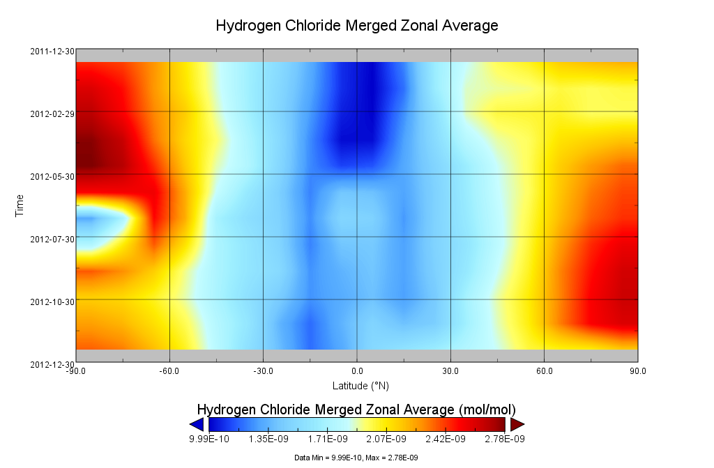
GOZCARDS Merged Hydrogen Chloride 1 month L3 10 degree Zonal Means on a Vertical Pressure Grid V1 (GozMmlpHCl) at GES DISC
National Aeronautics and Space Administration —
The GOZCARDS Merged Data for Hydrogen Chloride 1 month L3 10 degree Zonal Averages on a Vertical Pressure Grid product (GozMmlpHCl) contains zonal means and related... -
Federal
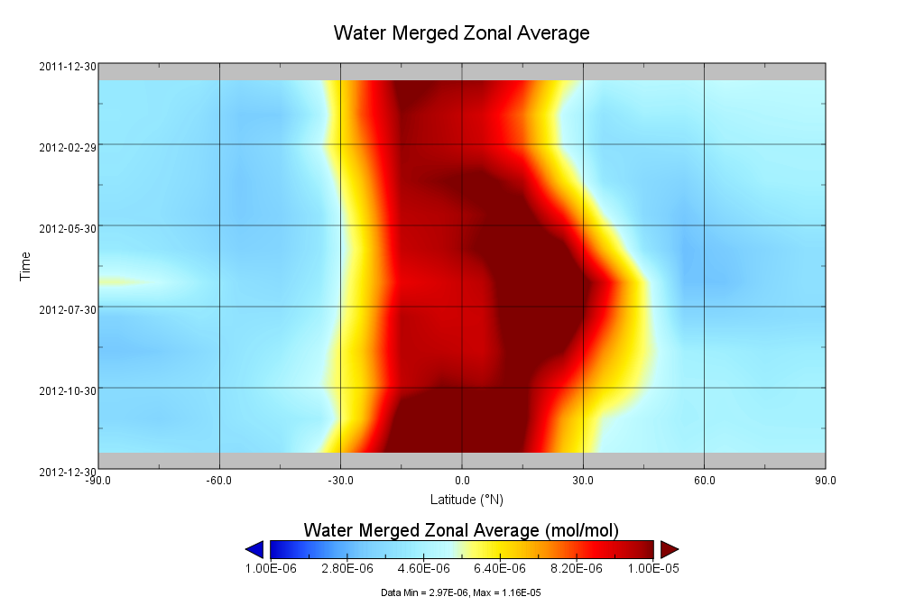
GOZCARDS Merged Water Vapor 1 month L3 10 degree Zonal Means on a Vertical Pressure Grid V1 (GozMmlpH2O) at GES DISC
National Aeronautics and Space Administration —
The GOZCARDS Merged Data for Water Vapor 1 month L3 10 degree Zonal Averages on a Vertical Pressure Grid product (GozMmlpH2O) contains zonal means and related... -
Federal
NGC 752 Chandra X-Ray Point Source Catalog
National Aeronautics and Space Administration —
This table provides a list of X-ray sources detected in a ~140 ks Chandra X-ray observation of the open cluster NGC 752. For the sources with 2MASS counterparts, the... -
Federal
Sloan Digital Sky Survey/UKIRT DSS Large Area Survey Matched Quasars Catalog
National Aeronautics and Space Administration —
This table contains a catalog of over 130,000 quasar candidates with near-infrared (NIR) photometric properties, with an areal coverage of approximately 1200 deg2.... -
Federal
LALA Bootes Field Chandra X-Ray Point Source Catalog
National Aeronautics and Space Administration —
This table contains the results of an analysis of a deep, 172 ks Chandra observation of the Large Area Lyman Alpha survey (LALA) Bootes field which was obtained with... -
Federal
Spitzer Deep Wide-Field Survey 4.5 micron Combined Catalog
National Aeronautics and Space Administration —
The Spitzer Deep, Wide-Field Survey (SDWFS) is a four-epoch infrared survey of 10 square degrees in the Boötes field of the NOAO Deep Wide-Field Survey using the IRAC... -
Federal
Carina OB1 Association XMM-Newton X-Ray Point Source Catalog
National Aeronautics and Space Administration —
This database table contains the Carina OB1 Association XMM-Newton X-Ray Point Source Catalog. The X-ray properties of the stellar population in the Carina OB1... -
Federal
Spitzer Wide-area InfraRed Extragalactic Survey ELAIS-N1 Optical-IRAC-MIPS24 Catalog
National Aeronautics and Space Administration —
The Spitzer Wide-area InfraRed Extragalactic survey (SWIRE), the largest Spitzer Legacy program, is a wide-area, imaging survey to trace the evolution of dusty, star-... -
Federal
H Persei Chandra X-Ray Point Source Catalog
National Aeronautics and Space Administration —
This table contains some of the results from a Chandra/ACIS-I observations of the massive ~ 13-14 Myr-old cluster, h Persei, part of the famous Double Cluster (h and... -
Federal
PEP PACS and MIPS Cross-IDs Catalog
National Aeronautics and Space Administration —
The PACS Evolutionary Probe (PEP, Lutz et al. 2011) is a Herschel guaranteed time deep extragalactic survey (KPGT_dlutz_1) targeting six among the most popular "blank... -
Federal
YSOVAR L1688 Object Table
National Aeronautics and Space Administration —
The YSOVAR (Young Stellar Object VARiability) Spitzer Space Telescope observing program obtained the first extensive mid-infrared (IRAC 3.6 and 4.5 micron) time... -
Federal
HEAO 1 A4 Spectra
National Aeronautics and Space Administration —
The UCSD/MIT Hard X-Ray and Low-Energy Gamma-Ray Instrument, A4, was flown on the HEAO 1 satellite, between August 1977 until January 1979. The experiment consisted... -
Federal
Bolocam Galactic Plane Survey Catalog v1
National Aeronautics and Space Administration —
The Version 2 release (hereafter v2) of the BGPS data includes images and a catalog. It is described in Ginsburg et al (2013).The new images have improved fidelity... -
Federal
Centaurus A Galaxy Chandra X-Ray Point Source Catalog
National Aeronautics and Space Administration —
This table contains the results from two Chandra X-ray Observatory observations of the X-ray point source population in the nearby radio galaxy Centaurus A (NGC...

Official websites use .gov
A
.gov website belongs to an official government
organization in the United States.
Secure .gov websites use HTTPS
A
lock (
) or https:// means you’ve safely connected to
the .gov website. Share sensitive information only on official,
secure websites.