
-
Federal
H00082: NOS Hydrographic Survey , 1839-12-31
National Oceanic and Atmospheric Administration, Department of Commerce —
The National Oceanic and Atmospheric Administration (NOAA) has the statutory mandate to collect hydrographic data in support of nautical chart compilation for safe... -
Federal
H13510: NOS Hydrographic Survey , 2021-09-06
National Oceanic and Atmospheric Administration, Department of Commerce —
The National Oceanic and Atmospheric Administration (NOAA) has the statutory mandate to collect hydrographic data in support of nautical chart compilation for safe... -
Federal
F00644: NOS Hydrographic Survey , 2014-07-23
National Oceanic and Atmospheric Administration, Department of Commerce —
The National Oceanic and Atmospheric Administration (NOAA) has the statutory mandate to collect hydrographic data in support of nautical chart compilation for safe... -
Federal
L02193: NOS Hydrographic Survey , 1948-12-31
National Oceanic and Atmospheric Administration, Department of Commerce —
The National Oceanic and Atmospheric Administration (NOAA) has the statutory mandate to collect hydrographic data in support of nautical chart compilation for safe... -
Federal
H06776: NOS Hydrographic Survey , 1942-12-31
National Oceanic and Atmospheric Administration, Department of Commerce —
The National Oceanic and Atmospheric Administration (NOAA) has the statutory mandate to collect hydrographic data in support of nautical chart compilation for safe... -
Federal
H12182: NOS Hydrographic Survey , Southern Chesapeake Bay, Virginia, 2010-03-24
National Oceanic and Atmospheric Administration, Department of Commerce —
The National Oceanic and Atmospheric Administration (NOAA) has the statutory mandate to collect hydrographic data in support of nautical chart compilation for safe... -
Federal
H06834: NOS Hydrographic Survey , 1943-12-31
National Oceanic and Atmospheric Administration, Department of Commerce —
The National Oceanic and Atmospheric Administration (NOAA) has the statutory mandate to collect hydrographic data in support of nautical chart compilation for safe... -
Federal
H06677: NOS Hydrographic Survey , 1941-12-31
National Oceanic and Atmospheric Administration, Department of Commerce —
The National Oceanic and Atmospheric Administration (NOAA) has the statutory mandate to collect hydrographic data in support of nautical chart compilation for safe... -
Federal
H06176: NOS Hydrographic Survey , 1936-12-31
National Oceanic and Atmospheric Administration, Department of Commerce —
The National Oceanic and Atmospheric Administration (NOAA) has the statutory mandate to collect hydrographic data in support of nautical chart compilation for safe... -
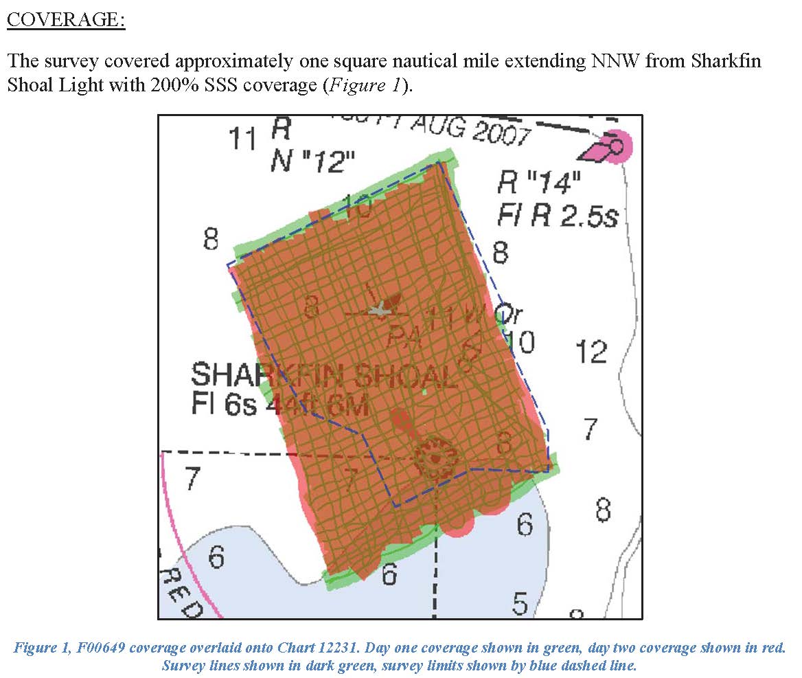
Federal
F00649: NOS Hydrographic Survey , 2014-10-17
National Oceanic and Atmospheric Administration, Department of Commerce —
The National Oceanic and Atmospheric Administration (NOAA) has the statutory mandate to collect hydrographic data in support of nautical chart compilation for safe... -
Federal
F00484: NOS Hydrographic Survey , Chart Investigations: Ports of Los Angeles and Long Beach, California, 2002-04-26
National Oceanic and Atmospheric Administration, Department of Commerce —
The National Oceanic and Atmospheric Administration (NOAA) has the statutory mandate to collect hydrographic data in support of nautical chart compilation for safe... -
Federal
Great Bay, NH (N130) Bathymetric Digital Elevation Model (30 meter resolution) Derived From Source Hydrographic Survey Soundings Collected by NOAA
National Oceanic and Atmospheric Administration, Department of Commerce —
Bathymetry for Great Bay was derived from six surveys containing 30,640 soundings. One older, less accurate, overlapping survey was omitted before tinning the data.... -
Federal
Central Washington Coast 1/3 arc-second NAVD 88 Digital Elevation Model
National Oceanic and Atmospheric Administration, Department of Commerce —
NOAA's National Geophysical Data Center (NGDC) is building high-resolution digital elevation models (DEMs) for select U.S. coastal regions. These integrated... -
Federal
Chesapeake Bay (M130) Bathymetric Digital Elevation Model - NOAA/NOS Estuarine Bathymetry
National Oceanic and Atmospheric Administration, Department of Commerce —
A 1/3 arc-second Mean Lower Low Water bathymetric DEM of NOS hydrographic survey data in the Chesapeake Bay Estuary. -
Federal
H11095: NOS Hydrographic Survey , East Northeast of St. George Island, Alaska, 2002-06-19
National Oceanic and Atmospheric Administration, Department of Commerce —
The National Oceanic and Atmospheric Administration (NOAA) has the statutory mandate to collect hydrographic data in support of nautical chart compilation for safe... -
Federal
Multibeam collection for FD170001: Multibeam data collected aboard Fugro Discovery from 09-Sep-17 to 17-Sep-17, Aberdeen, Scotland to St. John's, Canada
National Oceanic and Atmospheric Administration, Department of Commerce —
This data set is part of a larger set of data called the Multibeam Bathymetry Database (MBBDB) where other similar data can be found -
Federal
F00882: NOS Hydrographic Survey , 2023-06-21
National Oceanic and Atmospheric Administration, Department of Commerce —
The National Oceanic and Atmospheric Administration (NOAA) has the statutory mandate to collect hydrographic data in support of nautical chart compilation for safe... -
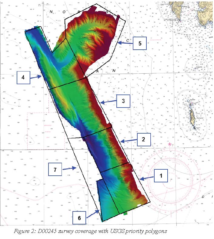
Federal
D00245: NOS Hydrographic Survey , 2018-06-29
National Oceanic and Atmospheric Administration, Department of Commerce —
The National Oceanic and Atmospheric Administration (NOAA) has the statutory mandate to collect hydrographic data in support of nautical chart compilation for safe... -
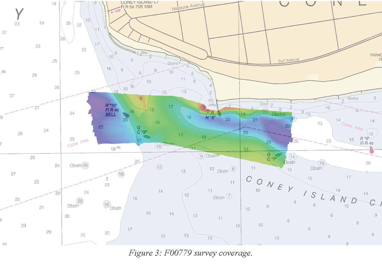
Federal
F00779: NOS Hydrographic Survey , 2019-07-18
National Oceanic and Atmospheric Administration, Department of Commerce —
The National Oceanic and Atmospheric Administration (NOAA) has the statutory mandate to collect hydrographic data in support of nautical chart compilation for safe... -
Federal
Barataria Bay (G200) Bathymetric Digital Elevation Model - NOAA/NOS Estuarine Bathymetry
National Oceanic and Atmospheric Administration, Department of Commerce —
A 1/3 arc-second Mean Lower Low Water bathymetric DEM of NOS hydrographic survey data in Barataria Bay.

Official websites use .gov
A
.gov website belongs to an official government
organization in the United States.
Secure .gov websites use HTTPS
A
lock (
) or https:// means you’ve safely connected to
the .gov website. Share sensitive information only on official,
secure websites.
.jpg)
.jpg)
.jpg)