
-
Federal
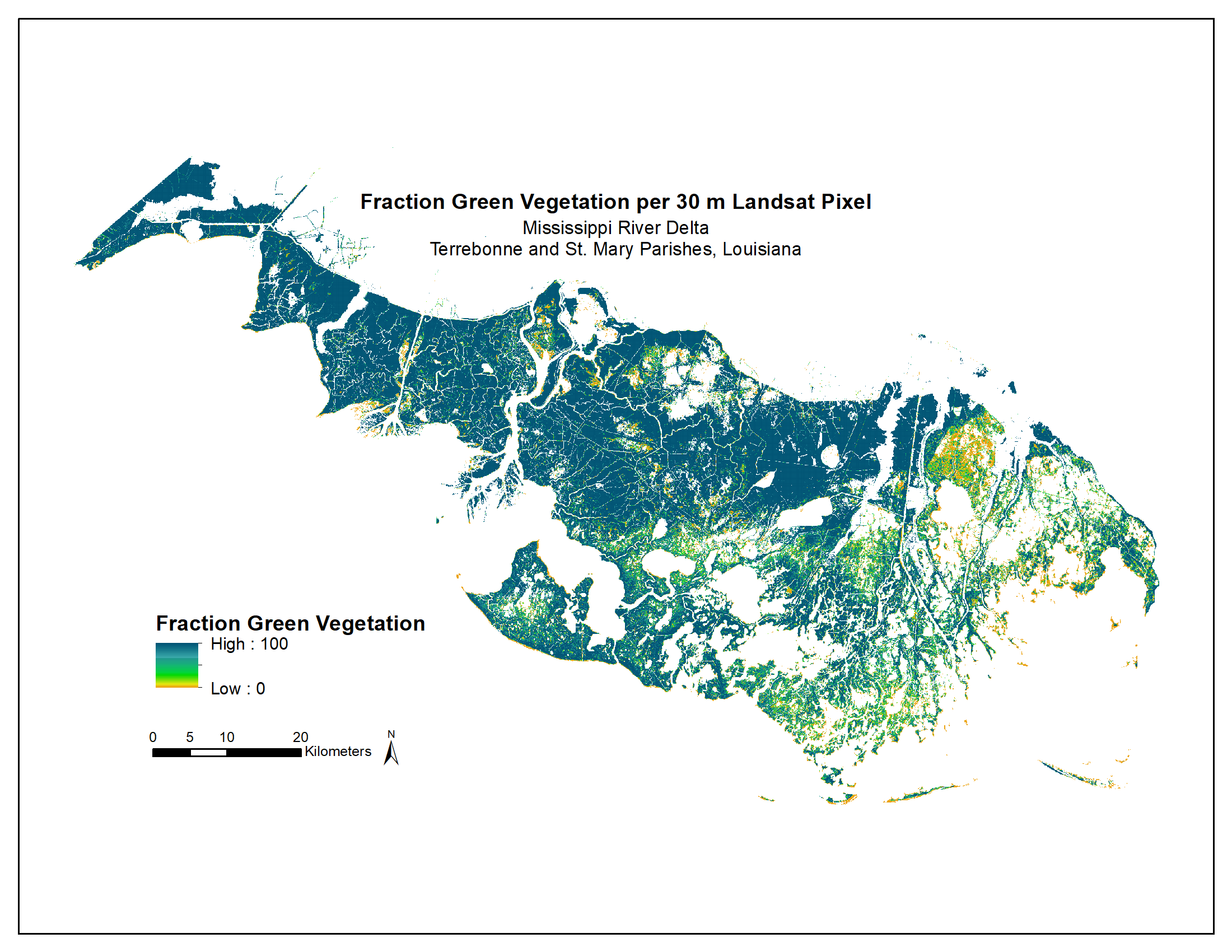
Green Vegetation Fraction High-Resolution Maps for Selected US Tidal Marshes, 2015
National Aeronautics and Space Administration —
This dataset provides 30m resolution maps of the fraction of green vegetation within tidal marshes for six estuarine regions of the conterminous United States: Cape... -
Federal
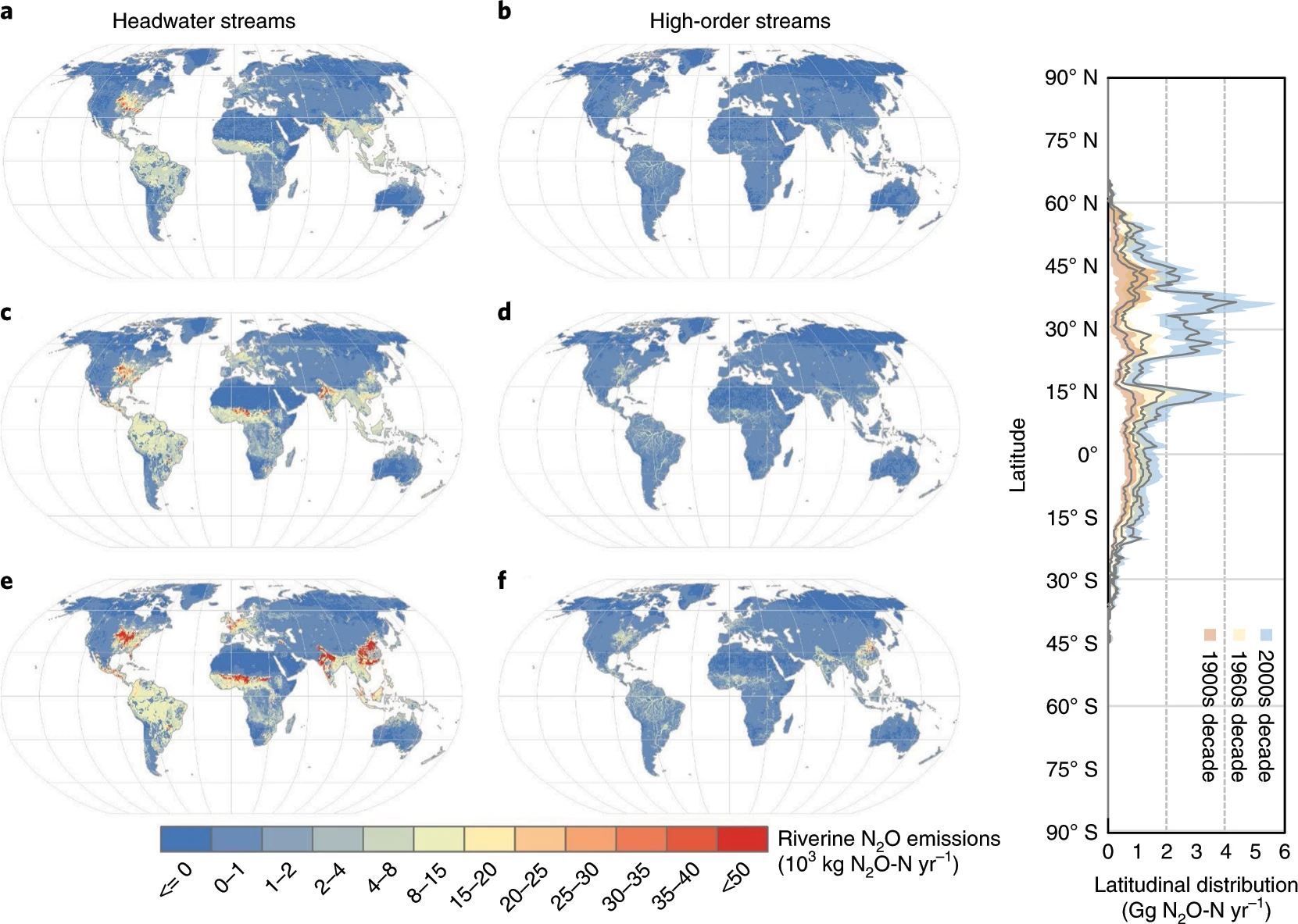
CMS: Annual Estimates of Global Riverine Nitrous Oxide Emissions, 1900-2016
National Aeronautics and Space Administration —
This dataset provides modeled estimates of annual nitrous oxide (N2O) emissions at a coarse geographic scale (0.5 x 0.5 degree) for two sets of global rivers and... -
Federal
NACP MsTMIP: Global and North American Driver Data for Multi-Model Intercomparison
National Aeronautics and Space Administration —
This data set provides environmental data that have been standardized and aggregated for use as input to carbon cycle models at global (0.5-degree resolution) and... -
Federal
Leaf Angle Data (FIFE)
National Aeronautics and Space Administration —
The Leaf Angle Data Data Set contains leaf angle distributions (LAD) obtained during the 1987 growing season for ten types of plant canopies, from the Konza Long-Term... -
Federal
Landsat-Derived Global Irrigated-Cropland Product L1 2020 30 m V002
National Aeronautics and Space Administration —
The Landsat-Derived Global Irrigated-Cropland Product Level 1 2020 (LGRIP30_L1_IRRI) Version 2 data provides high-resolution, 30 meter (m) cropland data to assist and... -
Federal
Mowing Experiment Biophys. Data (FIFE)
National Aeronautics and Space Administration —
The Mowing Experiment Biophysical Measurements data set was collected to quantify the effects of grazing and nitrogen fertilization on primary productivity and plant... -
Federal
LBA-ECO ND-04 Secondary Forest Recovery, Structure, and LAI, Central Amazonia, Brazil
National Aeronautics and Space Administration —
This data set reports measurements of the canopy and structure of secondary forests regenerating from abandoned pastures. These secondary forests are located in the... -
Federal
LBA-ECO ND-07 Hydrochemistry of Natural and Developed Land Cover, Brasilia, Brazil
National Aeronautics and Space Administration —
This data set reports on dissolved nutrient concentrations, as well as dissolved oxygen, alkalinity, conductivity, turbidity, and pH measured in water samples... -
Federal
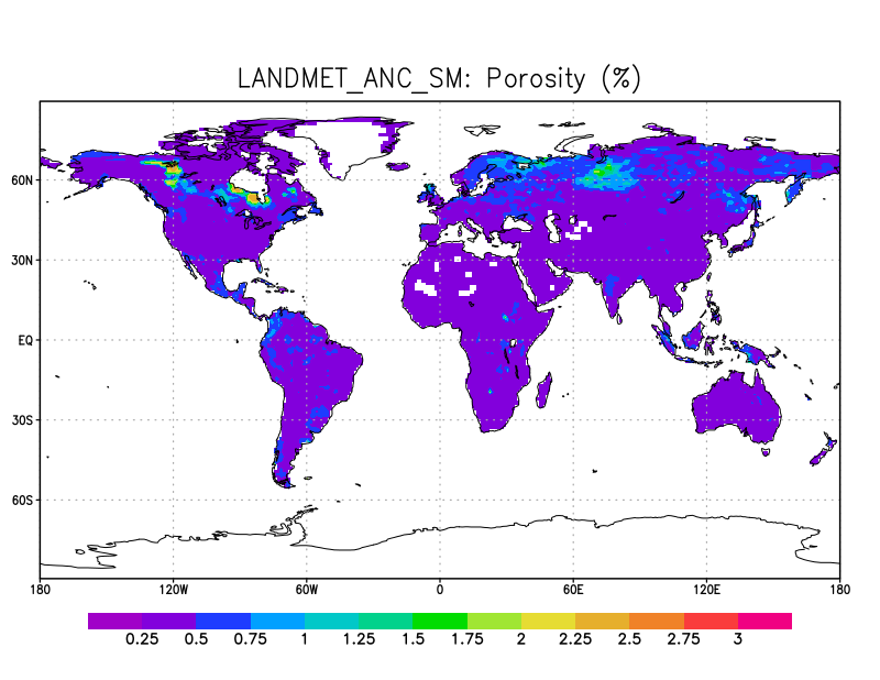
LANDMET Ancillary Soil Moisture data L3 V1 (LANDMET_ANC_SM) at GES DISC
National Aeronautics and Space Administration —
This ancillary climatology soil porosity and wetlands coverage information were derived from the daily GEWEX fusion of satellite active and passive microwave... -
Federal
LBA Regional Land Cover from AVHRR, 1-km, 1992-1993 (Hansen et al.)
National Aeronautics and Space Administration —
This data set is a subset of Hansen et al. (1999), "1 km Global Land Cover Data Set Derived from AVHRR," which was developed at the Laboratory for Global Remote... -
Federal
LBA Regional Land Cover from AVHRR, 1-Degree, 1987 (Defries and Townshend)
National Aeronautics and Space Administration —
This data set consists of a subset for the study area of the Large Scale Biosphere-Atmosphere Experiment in Amazonia (LBA) in South America (i.e., longitude 85 deg to... -
Federal
LBA-ECO ND-02 Landsat Imagery, Para, Brazil: 1984, 1994, and 1999
National Aeronautics and Space Administration —
This data set provides Landsat images of the county of Sao Francisco do Para located in the Bragantina region of Para, Brazil, the oldest agriculture frontier in... -
Federal
Landsat-Derived Global Rainfed-Cropland Product L1 2020 30 m V002
National Aeronautics and Space Administration —
The Landsat-Derived Global Rainfed-Cropland Product Level 1 2020 (LGRIP30_L1_RAIN) Version 2 data provides high-resolution, 30 meter (m) cropland data to assist and... -
Federal
LBA-ECO ND-07 Trace Gas Fluxes Under Multiple Land Uses, Brazil: 1999-2004
National Aeronautics and Space Administration —
This data set reports on soil-atmosphere fluxes of trace carbon dioxide, carbon monoxide, nitrous oxide, and nitric oxide (CO2, CO, N2O, NO) under various natural and... -
Federal
NPP Multi-Biome: Production and Mortality for Eastern US Forests, 1962-1996, R1
National Aeronautics and Space Administration —
There are two data files (tab-delimited .txt format) with this data set that provide estimates of above-ground biomass per county; county-level annual above-ground... -
Federal
SAFARI 2000 Land Cover from AVHRR, 1-km, 1992-1993 (Hansen et al.)
National Aeronautics and Space Administration —
The data set consists of a southern African subset of the 1-km Global Land Cover Data Set Derived from AVHRR developed at the Laboratory for Global Remote Sensing... -
Federal
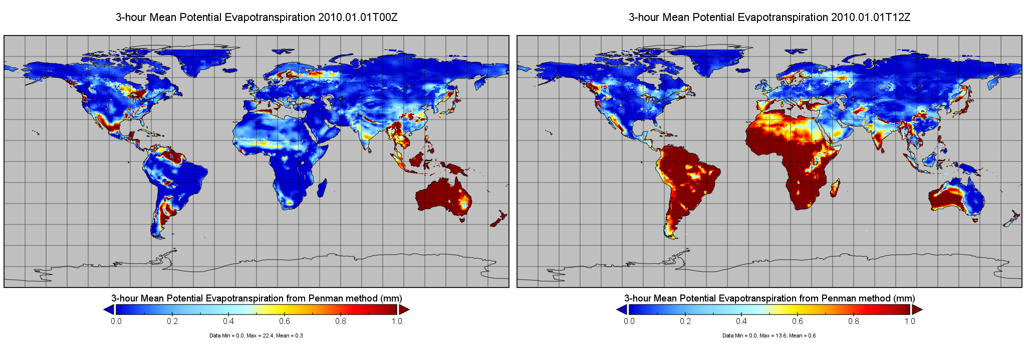
RM-OBS/PU Potential Evapotranspiration and Supporting Forcing L4 3-hourly 0.25x0.25 degree V002 (PET_PU_3H025) at GES DISC
National Aeronautics and Space Administration —
This is version 2 of Princeton University MEaSUREs Potential Evapotranspiration (PET) dataset, which provides a set of estimates of PET based on near surface... -
Federal
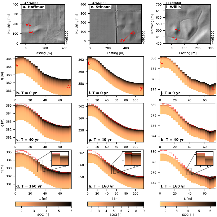
Topographic and Soil Carbon Reconstructions in Agricultural Fields, Iowa
National Aeronautics and Space Administration —
This dataset contains model predictions of soil erosion and soil organic carbon (SOC) redistribution caused by agricultural practices such as tillage erosion. Soil... -
Federal
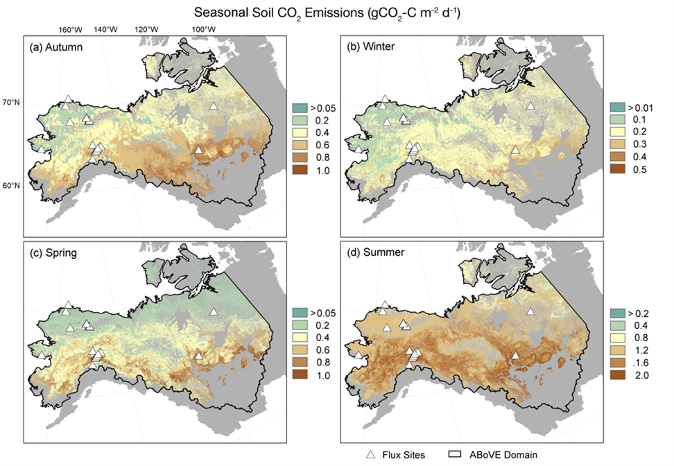
Soil Respiration Maps for the ABoVE Domain, 2016-2017
National Aeronautics and Space Administration —
This dataset provides gridded estimates of carbon dioxide (CO2) emissions from soil respiration occurring within permafrost-affected tundra and boreal ecosystems of... -
Federal
Site Averaged Flux Data: 1987-1989 (Betts)
National Aeronautics and Space Administration —
The Site Averaged Flux Data: 1987 (Betts) Data Set contains the site averaged product data collected by many PIs during the 1987-1989 FIFE experiment. Data are in 30...

Official websites use .gov
A
.gov website belongs to an official government
organization in the United States.
Secure .gov websites use HTTPS
A
lock (
) or https:// means you’ve safely connected to
the .gov website. Share sensitive information only on official,
secure websites.