
-
Federal
NPP Multi-Biome: Global Osnabruck Data, 1937-1981, R1
National Aeronautics and Space Administration —
This data set contains three files. The first file provides net primary productivity (NPP) estimates, vegetation characteristics, and summary climate data for 720... -
Federal
TROPESS CrIS-SNPP L2 Carbon Monoxide for West Coast Fires HiRes, Standard Product V1 (TRPSDL2COCRSWCFHI) at GES DISC
National Aeronautics and Space Administration —
The TROPESS CrIS-SNPP L2 Carbon Monoxide for West Coast Fires HiRes, Standard Product contains the vertical distribution of the retrieved atmospheric state of carbon... -
Federal
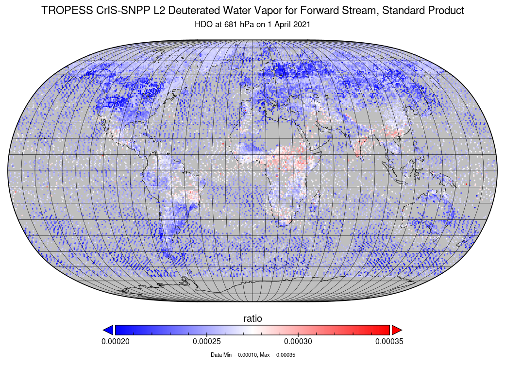
TROPESS CrIS-SNPP L2 Deuterated Water Vapor for Forward Stream, Standard Product V1 (TRPSDL2HDOCRSFS) at GES DISC
National Aeronautics and Space Administration —
The TROPESS CrIS-SNPP L2 Deuterated Water Vapor for Forward Stream, Standard Product contains the vertical distribution of the retrieved atmospheric state of semi-... -
Federal
TROPESS CrIS-SNPP L2 Peroxyacetyl Nitrate for Australian Fires, Standard Product V1 (TRPSDL2PANCRSAUS) at GES DISC
National Aeronautics and Space Administration —
The TROPESS CrIS-SNPP L2 Peroxyacetyl Nitrate for Australian Fires, Standard Product contains the vertical distribution of the retrieved atmospheric state of... -
Federal
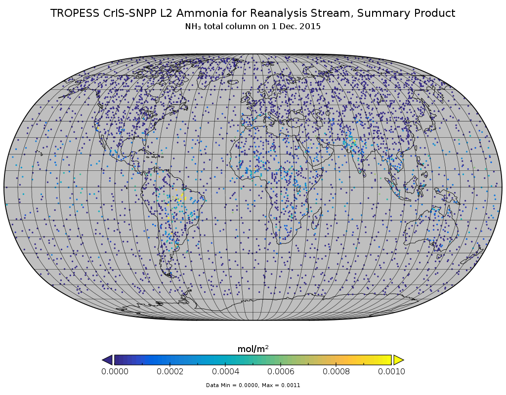
TROPESS CrIS-SNPP L2 Ozone for Forward Stream, Summary Product V1 (TRPSYL2O3CRSFS) at GES DISC
National Aeronautics and Space Administration —
The TROPESS CrIS-SNPP L2 Ozone for Forward Stream, Summary Product contains the vertical distribution of the retrieved atmospheric state of ozone (O3), and formal... -
Federal
LBA-ECO CD-10 H2O Profiles at km 67 Tower Site, Tapajos National Forest
National Aeronautics and Space Administration —
This data set reports vertical profiles of H2O vapor concentrations measured at the Para Western (Santarem) - km 67, Primary Forest Tower Site (Figure 1). This site... -
Federal
LBA-ECO CD-06 CO2 Exchange in River Systems Across the Amazon Basin: 2004-2007
National Aeronautics and Space Administration —
This data set provides measurements of carbon dioxide flux rates (FCO2), gas transfer velocity (k), and partial pressures (pCO2) at 75 sites on rivers and streams of... -
Federal
ISLSCP II Globalview: Atmospheric CO2 Concentrations
National Aeronautics and Space Administration —
The GlobalView Carbon Dioxide (CO2) data product contains synchronized and smoothed time series of atmospheric CO2 concentrations at selected sites that were created... -
Federal
GPM PR on TRMM Reflectivity, Precipitation Characteristics and Rate, at Surface and Profile L2 1.5 hours V07 (GPM_2APR) at GES DISC
National Aeronautics and Space Administration —
This is the new, GPM-like, format for TRMM Precipitation Radar L2 data that now incorporates what was known as 2A21, 2A23 and 2A25 datasets.The primary purpose of... -
Federal
CERES and GEO-Enhanced TOA, Within-Atmosphere and Surface Fluxes, Clouds and Aerosols Daily Terra-NOAA20 Edition4A
National Aeronautics and Space Administration —
CER_SYN1deg-Day_Terra-NOAA20_Edition4A is the Clouds and the Earth's Radiant Energy System (CERES) and geostationary (GEO)-Enhanced Top-of-Atmosphere (TOA), Within-... -
Federal
ABoVE: Burn Severity of Soil Organic Matter, Northwest Territories, Canada, 2014-2015
National Aeronautics and Space Administration —
This dataset provides maps at 30-m resolution of landscape surface burn severity (surface litter and soil organic layers) from the 2014-2015 fires in the Northwest... -
Federal
ABoVE: Soil Temperature Profiles, USArray Seismic Stations, AK and Canada, 2016-2019
National Aeronautics and Space Administration —
This dataset includes soil temperature profile measurements taken at 16 monitoring sites in Alaska, USA, and at one site in Yukon, Canada. The six sites are... -
Federal
Calculated Leaf Carbon and Nitrogen, 1992 (ACCP)
National Aeronautics and Space Administration —
The purpose of these measurements was to determine plot-level average leaf concentrations of nitrogen, lignin, cellulose, etc. in order to investigate how AVIRIS... -
Federal
CERES and GEO-Enhanced TOA, Within-Atmosphere and Surface Fluxes, Clouds and Aerosols Monthly-Averaged 1-Hourly Terra-Aqua Edition4A
National Aeronautics and Space Administration —
CER_SYN1deg-MHour_Terra-Aqua-MODIS_Edition4A is the Clouds and the Earth's Radiant Energy System (CERES) and geostationary (GEO)-Enhanced Top-of-Atmosphere (TOA),... -
Federal
BOREAS TE-18 Landsat TM Physical Classification Image of the NSA
National Aeronautics and Space Administration —
The objective of this classification is to provide the BOREAS investigators with a data product that characterizes the land cover of the NSA. A Landsat-5 TM image... -
Federal
AM Bench 2018 Residual Elastic Strain Measurements of 3D Additive Manufacturing Builds of IN625 Artifacts Using Neutron Diffraction and Synchrotron X-ray Diffraction
Department of Commerce —
The development of large residual elastic strains and stresses during laser powder-bed fusion (LPBF) additive manufacturing is one of the most significant barriers to... -
Federal
TROPICS05 L2B Neural-network Atmospheric Vertical Temperature & Moisture Profiles V0.2
National Aeronautics and Space Administration —
The "Time-Resolved Observations of Precipitation structure and storm Intensity with a Constellation of Smallsats" (TROPICS) mission has a goal of providing nearly... -
Federal
BOREAS Level-1B MAS Imagery: At-Sensor Radiance, Relative X and Y Coordinates
National Aeronautics and Space Administration —
For BOREAS, the MAS images, along with the other remotely sensed data, were collected to provide spatially-extensive information over the primary study areas. This...

Official websites use .gov
A
.gov website belongs to an official government
organization in the United States.
Secure .gov websites use HTTPS
A
lock (
) or https:// means you’ve safely connected to
the .gov website. Share sensitive information only on official,
secure websites.