

1,571 datasets found for "棋牌游戏赌博✅澳门葡京赌场官方网站-网址【079.one】㊙️最火爆PG电子超高爆奖率,注册即送38元.LBRVAoOwNGqTkKn"
-
University
Cadastral PLSS Standardized Data - PLSSFirstDivision, NE - Version 1.1
Earth Data Analysis Center, University of New Mexico —
This feature class is part of the Cadastral National Spatial Data Infrastructure (NSDI) CADNSDI publication data set for rectangular and non-rectangular Public Land... -
State
Bedrock Terrane Contacts
State of Connecticut —
This data table lists the valid values for the TERRB_COD and TERR_BNDRY data fields in the Connecticut Bedrock Geology Line (BEDROCK_GEOLOGY_LINE) feature class.... -
State
Shellfish Bed Managed Polygon
State of Connecticut —
Shellfish Beds Managed Set: The Connecticut Department of Environmental Protection cooperated with the Department of Agriculture, Bureau of Aquaculture to publish the... -
Federal
System Level Evaluation of UE-to-Network Relays in D2D-enabled LTE Networks
Department of Commerce —
The data in this document corresponds to the results presented in the paper entitled "System Level Evaluation of UE-to-Network Relays in D2D-enabled LTE Networks", to... -
State
Erosion Susceptibility Sites
State of Connecticut —
Connecticut Erosion Susceptibility a 1:24,000-scale, polygon feature-based layer that was developed as a predictive tool to show areas most susceptible to terrace... -
Federal
Data from Fire Resilience of a Steel-Concrete Composite Floor System: Full-Scale Experimental Evaluation for Influence of Slab Reinforcement (Test #2)
National Institute of Standards and Technology —
The National Institute of Standards and Technology conducted a series of large compartment fire tests to investigate the behavior and fire-induced failure mechanisms... -
Federal
TSS Individual Results with Comments Data Dictionary
General Services Administration —
A Data Dictionary for the TSS Individual Reports with Comments reports. -
Federal
August 2014 Dixie Valley Binary Costs
Department of Energy —
Binary Costs and man-hour data supporting the technical and economic feasibility of utilizing the available unused heat to generate additional electric power from a... -
Federal
Offshore Wind - Cable Landings (Proposed or Installed)
Department of the Interior —
MetadataThese data show proposed or currently installed locations where offshore export cables will make or have made landfall. For proposed landings, if more than... -
Federal
Assessment of Non-Occupational 1,4-Dioxane Exposure Pathways from Drinking Water and Product Use
U.S. Environmental Protection Agency —
S1. Additional details on model input data, parameter estimation, and model development (PDF) S2. Model input data and supplemental results (XLSX) S3. Model... -
Federal
LRIR/Nimbus-6 Level 2 Inverted Profiles of Temperature and Ozone V001 (LRIRN6L2IPAT) at GES DISC
National Aeronautics and Space Administration —
LRIRN6L2IPAT is the Nimbus-6 Limb Radiance Inversion Radiometer (LRIR) Level 2 Inverted Profiles of Temperature and Ozone data product. The product contains daily... -
Federal
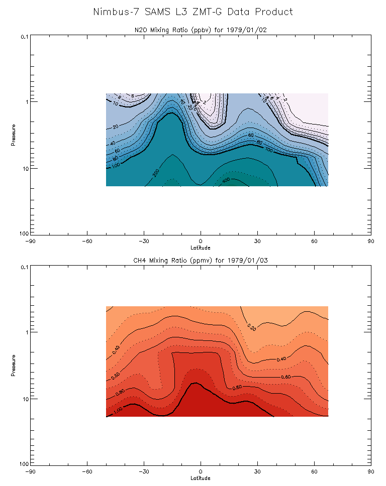
SAMS/Nimbus-7 Level 3 Zonal Means Composition Data V001 (SAMSN7L3ZMTG) at GES DISC
National Aeronautics and Space Administration —
SAMSN7L3ZMTG is the Nimbus-7 Stratospheric and Mesospheric Sounder (SAMS) Level 3 Zonal Means Composition Data Product. The Earth's surface is divided into 2.5-deg... -
Federal
TIROS-4 Medium-Resolution Scanning Radiometer Level 1 Final Meteorological Radiation Data V001 (TIROS4L1FMRT) at GES DISC
National Aeronautics and Space Administration —
TIROS-4 Medium-Resolution Scanning Radiometer Level 1 Final Meteorological Radiation Data (FMRT) product contains radiances expressed in five infrared/visible... -
Federal
TIROS-3 Medium-Resolution Scanning Radiometer Level 1 Final Meteorological Radiation Data V001 (TIROS3L1FMRT) at GES DISC
National Aeronautics and Space Administration —
TIROS-3 Medium-Resolution Scanning Radiometer Level 1 Final Meteorological Radiation Data (FMRT) product contains radiances expressed in five infrared/visible... -
Federal
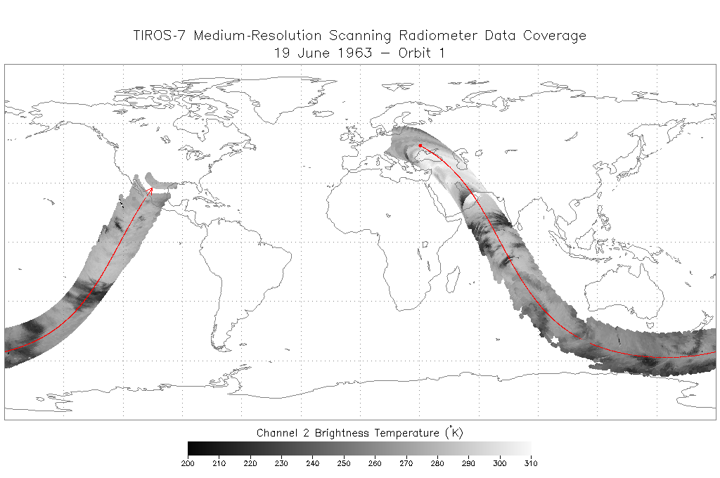
TIROS-7 Medium-Resolution Scanning Radiometer Level 1 Final Meteorological Radiation Data V001 (TIROS7L1FMRT) at GES DISC
National Aeronautics and Space Administration —
TIROS-7 Medium-Resolution Scanning Radiometer Level 1 Final Meteorological Radiation Data (FMRT) product contains radiances expressed in five infrared/visible... -
State
Los Angeles River Restoration and Access (LLARRA) Water Quality Analysis - Lower Los Angeles River - 2024-2025
State of California —
WCB Grant 2023114: Lower Los Angeles River Restoration and Access: Data includes one (1) year of water quality analysis to inform the design and serve as a baseline... -
Federal
BLM Natl WesternUS FIAT Project Planning Areas 2015 Polygon
Department of the Interior —
This data represents a management strategy of the Fire and Invasives Assessment Tool (FIAT). Project Planning Area (PPA) polygons are part of the FIAT Step 2 process.... -
Federal
VMS Groundfish 2010-2017 (BOEM)
Department of the Interior —
2010-2017 Vessel Monitoring System (VMS) data were used from the NOAA Office of Law Enforcement to create this fishing effort dataset for the U.S. West Coast. The... -
Federal
Generator Fleet Characteristics Model
Department of Commerce —
When run, the GFCM creates tabular and graphical data of the hourly operating status and market outcomes for the generators that make up the electric generating fleet. -
Federal
Sequence-based allelic variations and frequencies for 22 autosomal STR loci in the Lebanese population - Supplementary material
Department of Commerce —
This data repository is meant to provide the supplementary files, tables, and figures included in the peer-reviewed research article entitled: "Sequence-based allelic...
1,571 datasets found for "棋牌游戏赌博✅澳门葡京赌场官方网站-网址【079.one】㊙️最火爆PG电子超高爆奖率,注册即送38元.LBRVAoOwNGqTkKn"