
-
City
Peak Hour Parking Restrictions
City of Seattle —
Identifies parking spaces where vehicles are not permitted to stop or park during specific time periods (as stated on sign). Data Source: SDOT.V_PEAKHRPARKINGData... -
University
Colfax County 2010 Census Blocks
Earth Data Analysis Center, University of New Mexico —
The TIGER/Line Files are shapefiles and related database files (.dbf) that are an extract of selected geographic and cartographic information from the U.S. Census... -
Federal
Weighing Lysimeter Data for The Bushland, Texas Maize for Grain Datasets
Department of Agriculture —
This dataset consists of six years of weighing lysimeter data for six seasons of maize (Zea mays, L., also known as corn in the United States) grown for grain at the... -
Federal
FBSAB Recruit Fish Habitat Use Surveys at Hawaii Island (Big Island), Main Hawaiian Islands, 2009 (NODC Accession 0073870)
National Oceanic and Atmospheric Administration, Department of Commerce —
Recruit-habitat relations (habitat use by recruits) were surveyed at 1 to ~5 m depths based on all "Encounters" of singletons and "groups" (where a group comprised... -
Federal
Data from: Acrylamide in fried sweetpotato chips: The relationship with free asparagine and effects of asparaginase
Department of Agriculture —
Data DescriptionThese data are ‘Bayou Belle’ sweetpotato raw and chip compositions and acrylamide contents of model sweetpotato systems. Raw composition includes dry... -
Federal
Data File for iAs Dose-response Manuscripts - Data files used in preparing four manuscripts describing dose-response methods that have been developed for the purposes of the EPA inorganic arsenic IRIS health assessment.
U.S. Environmental Protection Agency —
These datasets contain information used in support of tables, figures and conclusions made in four manuscripts related to EPA methods developed for the dose-response... -
Federal
Utah FORGE 5-2557: Wellbore Breakout Tests Data
Department of Energy —
Included are datasets from wellbore breakout experiments conducted under triaxial conditions with varying fluid and temperature environments. This dataset serves as... -
State
Quaternary Geology Geologic Basin Boundary
State of Connecticut —
Connecticut Quaternary Geology Geologic Basin Divides includes the drainage basins divides appearing on Sheet 1 of the The Quaternary Geologic Map of Connecticut and... -
Federal
Ozone- Induced Acute Phase Response in Lung Versus Liver: The Role of Adrenal-Derived Stress Hormones
U.S. Environmental Protection Agency —
The data set pertains to the published research results in a given paper. Individual observations are shown for each pertaining figure or table in the paper. Each... -
Federal
State Summary Arkansas FY2017
Department of Veterans Affairs —
The FY2017 State Summaries provide an overview of benefits, services, demographics and population of Veterans analyzed by state. -
Federal
NOAA/WDS Paleoclimatology - GISP2 Ice Core 1000 Year Ar-N2 Isotope Temperature Reconstruction
National Oceanic and Atmospheric Administration, Department of Commerce —
This archived Paleoclimatology Study is available from the NOAA National Centers for Environmental Information (NCEI), under the World Data Service (WDS) for... -
State
Water Rights Demand Analysis Methodology Datasets
State of California —
The following datasets are used for the Water Rights Demand Analysis project and are formatted to be used in the calculations. The State Water Resources Control Board... -
Federal
LRIR/Nimbus-6 Level 2 Inverted Profiles of Temperature and Ozone V001 (LRIRN6L2IPAT) at GES DISC
National Aeronautics and Space Administration —
LRIRN6L2IPAT is the Nimbus-6 Limb Radiance Inversion Radiometer (LRIR) Level 2 Inverted Profiles of Temperature and Ozone data product. The product contains daily... -
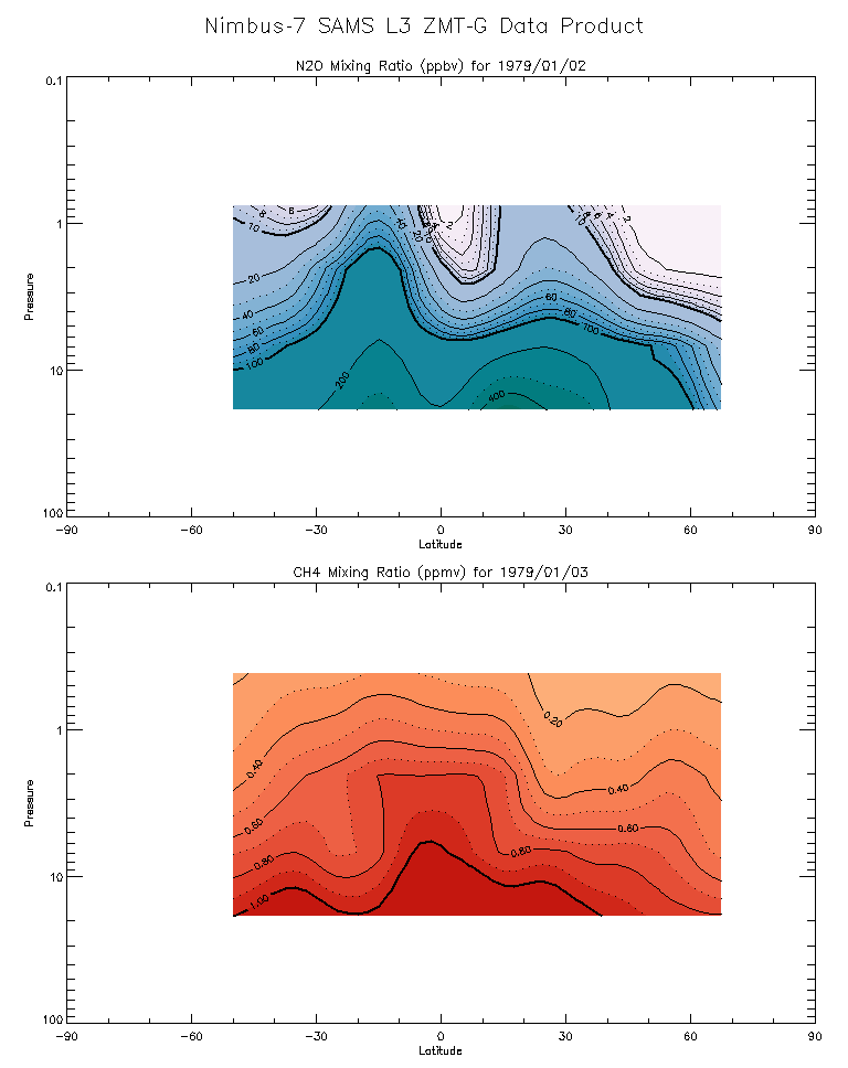
Federal
SAMS/Nimbus-7 Level 3 Zonal Means Composition Data V001 (SAMSN7L3ZMTG) at GES DISC
National Aeronautics and Space Administration —
SAMSN7L3ZMTG is the Nimbus-7 Stratospheric and Mesospheric Sounder (SAMS) Level 3 Zonal Means Composition Data Product. The Earth's surface is divided into 2.5-deg... -
Federal
TIROS-4 Medium-Resolution Scanning Radiometer Level 1 Final Meteorological Radiation Data V001 (TIROS4L1FMRT) at GES DISC
National Aeronautics and Space Administration —
TIROS-4 Medium-Resolution Scanning Radiometer Level 1 Final Meteorological Radiation Data (FMRT) product contains radiances expressed in five infrared/visible... -
Federal
TIROS-3 Medium-Resolution Scanning Radiometer Level 1 Final Meteorological Radiation Data V001 (TIROS3L1FMRT) at GES DISC
National Aeronautics and Space Administration —
TIROS-3 Medium-Resolution Scanning Radiometer Level 1 Final Meteorological Radiation Data (FMRT) product contains radiances expressed in five infrared/visible... -
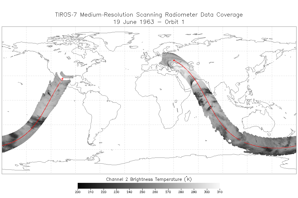
Federal
TIROS-7 Medium-Resolution Scanning Radiometer Level 1 Final Meteorological Radiation Data V001 (TIROS7L1FMRT) at GES DISC
National Aeronautics and Space Administration —
TIROS-7 Medium-Resolution Scanning Radiometer Level 1 Final Meteorological Radiation Data (FMRT) product contains radiances expressed in five infrared/visible... -
State
Los Angeles River Restoration and Access (LLARRA) Water Quality Analysis - Lower Los Angeles River - 2024-2025
State of California —
WCB Grant 2023114: Lower Los Angeles River Restoration and Access: Data includes one (1) year of water quality analysis to inform the design and serve as a baseline... -
Federal
BLM Natl WesternUS FIAT Project Planning Areas 2015 Polygon
Department of the Interior —
This data represents a management strategy of the Fire and Invasives Assessment Tool (FIAT). Project Planning Area (PPA) polygons are part of the FIAT Step 2 process.... -
Federal
VMS Groundfish 2010-2017 (BOEM)
Department of the Interior —
2010-2017 Vessel Monitoring System (VMS) data were used from the NOAA Office of Law Enforcement to create this fishing effort dataset for the U.S. West Coast. The...

Official websites use .gov
A
.gov website belongs to an official government
organization in the United States.
Secure .gov websites use HTTPS
A
lock (
) or https:// means you’ve safely connected to
the .gov website. Share sensitive information only on official,
secure websites.