

1,474 datasets found for "c94최신주식디비추출디비판매(($텔레ErrorBased~ㅡ+"
-
Federal
MLS/Aura Level 2 Carbon Monoxide (CO) Mixing Ratio V004 (ML2CO) at GES DISC
National Aeronautics and Space Administration —
ML2CO is the EOS Aura Microwave Limb Sounder (MLS) standard product for carbon monoxide derived from radiances measured by the 640 GHz radiometer. The data version is... -
Federal
AMSR-E/Aqua level 3 global monthly Surface Soil Moisture Averages V005 (AMSRE_AVRMO) at GES DISC
National Aeronautics and Space Administration —
The dataset contains global monthly-mean soil moisture statistics (average values) for 1 by 1 degree grid cells. The source for the data is AMSR-E daily estimates of... -
Federal
AMSR-E/Aqua level 3 global monthly Surface Soil Moisture Standard Deviation V005 (AMSRE_STDMO) at GES DISC
National Aeronautics and Space Administration —
The dataset contains global monthly soil moisture statistics (standard deviation ) for 1 by 1 degree grid cells. The source for the data is AMSR-E daily estimates of... -
Federal
AMSR-E/Aqua surface soil moisture (LSMEM) L3 1 day 0.25 degree x 0.25 degree V001 (WC_LSMEM_SOILM_025) at GES DISC
National Aeronautics and Space Administration —
AMSR-E/Aqua surface soil moisture (LSMEM) L3 1 day 0.25 degree x 0.25 degree V001 is a global, 10-year (2002-2011) data set. It is created from soil moisture... -
Federal
GVHRR/ATS-6 Black and White Infrared Images on Film V001 (GVHRRATS6IMIR) at GES DISC
National Aeronautics and Space Administration —
GVHRRATS6IMIR is the Geosynchronous Very High Resolution Radiometer (GVHRR) Black and White Infrared Images on 70mm Film data product from the sixth Applications... -
Federal
GPM ATMS on NOAA-20 (GPROF) Climate-based Radiometer Precipitation Profiling L3 1 day 0.25 degree x 0.25 degree V07 (GPM_3GPROFNOAA20ATMS_DAY_CLIM) at GES DISC
National Aeronautics and Space Administration —
Version 07 is the current version of the data set. Older versions are no longer available and have been superseded by Version 07. The "CLIM" products differ from... -
Federal
GPM DPR Ku Precipitation Profile 2A 1.5 hours 5 km V07 (GPM_2AKu) at GES DISC
National Aeronautics and Space Administration —
Version 07 is the current version of the data set. Older versions will no longer be available and have been superseded by Version 07. The 2AKu algorithm is a single-... -
Federal
VISSR/GOES-3 Visible Imagery on 70mm Film V001 (VISSRGOES3IMVIS) at GES DISC
National Aeronautics and Space Administration —
VISSRGOES3IMVIS is the Visible Infrared Spin-Scan Radiometer (VISSR) Visible Imagery on 70mm Film data product from the third Geostationary Operational Environmental... -
Federal
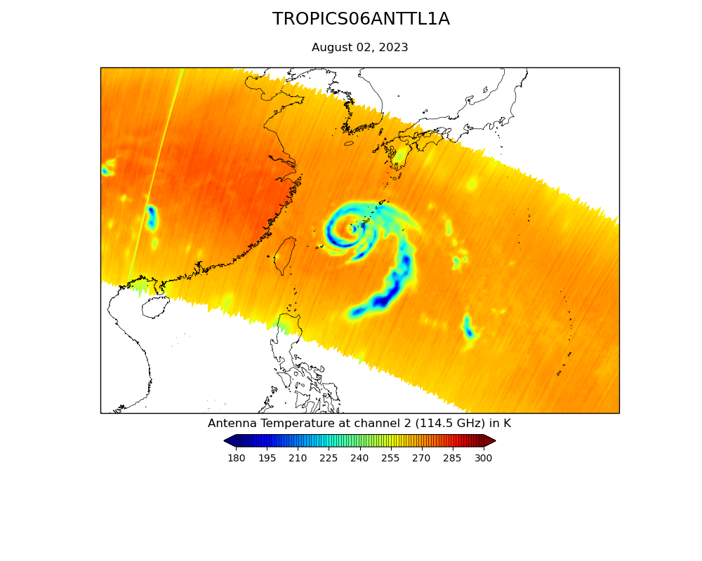
TROPICS07 L1A Orbital Geolocated Native-Resolution Antenna Temperatures V0.2
National Aeronautics and Space Administration —
The "Time-Resolved Observations of Precipitation structure and storm Intensity with a Constellation of Smallsats" (TROPICS) mission has a goal of providing nearly... -
Federal
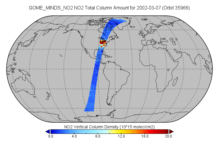
OMPS-NPP L2 NM Nitrogen Dioxide (NO2) Total and Tropospheric Column swath orbital V2 (OMPS_NPP_NMNO2_L2) at GES DISC
National Aeronautics and Space Administration —
The OMPS-NPP L2 NM Nitrogen Dioxide (NO2) Total and Tropospheric Column swath orbital collection 2 version 2.0 product contains the retrieved nitrogen dioxide (NO2)... -
Federal
OMPS-N20 NM PCA SO2 Step 1 Total Column 1-Orbit L2 Swath 17x13km
National Aeronautics and Space Administration —
The OMPS-N20 NM PCA SO2 Step1 Total Column 1-Orbit L2 Swath 17x13km collection 1 product contains the retrieved sulfur dioxide (SO2) measured by the Ozone Mapping and... -
Federal
FLDAS Noah Land Surface Model L4 Global Monthly 0.1 x 0.1 degree (GDAS and CHIRPS-PRELIM) V001 (FLDAS_NOAH01_CP_GL_M) at GES DISC
National Aeronautics and Space Administration —
This dataset contains a series of land surface parameters simulated from the Noah 3.6.1 model in the Famine Early Warning Systems Network (FEWS NET) Land Data... -
Federal
GPM ATMS on NOAA-20 (GPROF) Radiometer Precipitation Profiling L3 1 month 0.25 degree x 0.25 degree V07 (GPM_3GPROFNOAA20ATMS) at GES DISC
National Aeronautics and Space Administration —
Version 07 is the current version of the data set. 3GPROF products provide global gridded monthly/daily precipitation averages from multiple satellites that can be... -
Federal
Sounder SIPS: JPSS-1 CrIS Level 3 Comprehensive Quality Control Gridded Monthly CLIMCAPS V2 (SNDRJ1IML3CMCCP) at GES DISC
National Aeronautics and Space Administration —
WARNING: To users of the derived product “co_mmr_midtrop” (carbon monoxide mass mixing ratio to dry air [kg/kg] at ~500 hPa). This variable has a significant bias due...
1,474 datasets found for "c94최신주식디비추출디비판매(($텔레ErrorBased~ㅡ+"