
-
Federal
GHRSST Level 2P Global Sea Surface Skin Temperature from the Moderate Resolution Imaging Spectroradiometer (MODIS) on the NASA Terra satellite (GDS2)
National Aeronautics and Space Administration —
NASA produces skin sea surface temperature (SST) products from the Infrared (IR) channels of the Moderate-resolution Imaging Spectroradiometer (MODIS) onboard the... -
Federal
GHRSST Level 2P 1 m Depth Global Sea Surface Temperature version 3.0 from the Visible Infrared Imaging Radiometer Suite (VIIRS) on the Suomi NPP satellite (GDS2)
National Aeronautics and Space Administration —
A global Group for High Resolution Sea Surface Temperature (GHRSST) Level 2P dataset based on retrievals from the Visible Infrared Imaging Radiometer Suite (VIIRS).... -
Federal
LBA-ECO LC-24 AVHRR Derived Fire Occurrence, 5-km Resolution, Amazonia: 2001
National Aeronautics and Space Administration —
This data set provides the number of hot spots detected across the legal Amazon Basin at 5- km resolution by the AVHRR (Advanced Very High Resolution Radiometer) on... -
Federal
2MASS LMC/SMC Calibration Merged Point Source Information Table
National Aeronautics and Space Administration —
Photometric calibration for 2MASS was performed using observations of calibration fields made at regular intervals during each night of survey operations.... -
Federal
ECOSTRESS Cloud Mask Daily L2 Global 70m V001
National Aeronautics and Space Administration —
The ECO2CLD Version 1 data product was decommissioned on May 21, 2025. Users are encouraged to use theFederalECOSTRESS Gridded Top of Atmosphere Calibrated Radiance Instantaneous L1C Global 70 m V002
National Aeronautics and Space Administration —
The ECOsystem Spaceborne Thermal Radiometer Experiment on Space Station (ECOSTRESS) mission measures the temperature of plants to better understand how much water...FederalCERES Time-Interpolated TOA Fluxes, Clouds and Aerosols Monthly Aqua Edition4A
National Aeronautics and Space Administration —
CER_SSF1deg-Month_Aqua-MODIS_Edition4A is the Clouds and the Earth's Radiant Energy System (CERES) Time-Interpolated Top of Atmosphere (TOA) Fluxes, Clouds and...FederalCATS-ISS Level 1B Day Mode 7.2 Version 3-00
National Aeronautics and Space Administration —
CATS-ISS_L1B_D-M7.2-V3-00 is the Cloud-Aerosol Transport System (CATS) International Space Station (ISS) Level 1B Day Mode 7.2 Version 3-00 data product. This...FederalASCENDS: Active Sensing of CO2 With AVOCET, California and Nevada, 2016
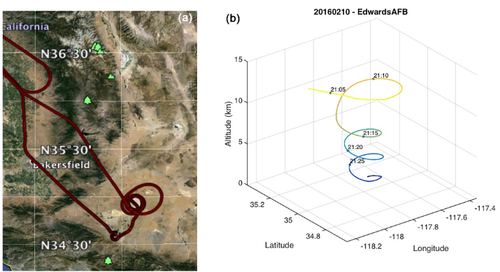
National Aeronautics and Space Administration —
This dataset provides in situ airborne measurements of atmospheric carbon dioxide (CO2) over California and Nevada on February 10-11, 2016. Measurements were taken...FederalMODIS/Aqua Land Surface Temperature/Emissivity Daily L3 Global 6km SIN Grid V006
National Aeronautics and Space Administration —
The MYD11B1 Version 6 data product was decommissioned on July 31, 2023. Users are encouraged to use the MYD11B1...FederalMODIS/Aqua Land Surface Temperature/Emissivity 8-Day L3 Global 0.05Deg CMG V006
National Aeronautics and Space Administration —
The MYD11C2 Version 6 data product was decommissioned on July 31, 2023. Users are encouraged to use the MYD11C2...FederalMODIS Aqua Level 3 SST Thermal IR Monthly 4km Daytime V2019.0
National Aeronautics and Space Administration —
Day and night spatially gridded (L3) global NASA skin sea surface temperature (SST) products from the Moderate-resolution Imaging Spectroradiometer (MODIS) onboard...FederalMODIS Terra Level 3 SST MID-IR Monthly 9km Nighttime V2019.0
National Aeronautics and Space Administration —
Day and night spatially gridded (L3) global NASA skin sea surface temperature (SST) products from the Moderate-resolution Imaging Spectroradiometer (MODIS) onboard...FederalMODIS Terra Level 3 SST MID-IR 8 Day 9km Nighttime V2019.0
National Aeronautics and Space Administration —
Day and night spatially gridded (L3) global NASA skin sea surface temperature (SST) products from the Moderate-resolution Imaging Spectroradiometer (MODIS) onboard...FederalMODIS Aqua Level 3 SST MID-IR 8 Day 4km Nighttime V2019.0
National Aeronautics and Space Administration —
Day and night spatially gridded (L3) global NASA skin sea surface temperature (SST) products from the Moderate-resolution Imaging Spectroradiometer (MODIS) onboard...FederalABoVE/ASCENDS: Atmospheric Backscattering Coefficient Profiles from CO2 Sounder, 2017
National Aeronautics and Space Administration —
This dataset provides atmospheric backscattering coefficient profiles collected during Active Sensing of CO2 Emissions over Nights, Days, and Seasons (ASCENDS)...FederalJune 1994 Java, Indonesia Images
National Oceanic and Atmospheric Administration, Department of Commerce —
On June 2, 1994 at 18:17:34 UTC, a magnitude 7.8 earthquake occurred 200 km off the southeastern coast of Java. The earthquake occurred at night, and awoke only about...1,457 datasets found for "Night"

Official websites use .gov
A
.gov website belongs to an official government
organization in the United States.
Secure .gov websites use HTTPS
A
lock (
) or https:// means you’ve safely connected to
the .gov website. Share sensitive information only on official,
secure websites.