
-
Federal
VIIRS/NPP BRDF/Albedo BSA at Solar Noon Band M4 Daily L3 Global 30ArcSec CMG V001
National Aeronautics and Space Administration —
The VNP43D57 Version 1 data product was decommissioned on July 31, 2025. Users are encouraged to use the VNP43D57 and VJ143D57 Version 2 data products.The NASA/NOAA... -
Federal
VIIRS/NPP BRDF/Albedo Albedo Daily L3 Global 1km SIN Grid V001
National Aeronautics and Space Administration —
The VNP43MA3 Version 1 data product was decommissioned on July 31, 2025. Users are encouraged to use the VNP43MA3 and VJ143MA3 Version 2 data products.The NASA/NOAA... -
Federal
VIIRS/JPSS2 Day/Night Band 6-Min L1B Swath SDR 750m NRT
National Aeronautics and Space Administration —
The Near Real Time (NRT) VIIRS Level 1 and Level 2 swath (VJ202DNB_NRT) product is single NASA VIIRS panchromatic Day-Night band (DNB) calibrated radiance product.... -
Federal
VIIRS/NPP Albedo Daily L3 Global 500m SIN Grid NRT
National Aeronautics and Space Administration —
The VIIRS/NPP Albedo Daily L3 Global 500 m SIN Grid Near Real Time (NRT), short-name VNP43IA3N product provides albedo values at 500 m resolution for the bi-... -
Federal
VIIRS/JPSS1 Albedo Daily L3 Global 500m SIN Grid NRT
National Aeronautics and Space Administration —
The VIIRS/JPSS1 Albedo Daily L3 Global 500 m SIN Grid Near Real Time (NRT), short-name VJ143IA3N product provides albedo values at 500 m resolution for the bi-... -
Federal
TROPICS06 L2B Atmospheric Vertical Temperature and Moisture Profiles (AVTP, AVMP) V1.0
National Aeronautics and Space Administration —
The "Time-Resolved Observations of Precipitation structure and storm Intensity with a Constellation of Smallsats" (TROPICS) mission has a goal of providing nearly... -
State
Chart 3.0.7 Total Number of Members who utilzed CS in the quarter 12-months prior to the last quarter of data
State of California —
ECM Community Support Services tables for a Quarterly Implementation Report. Including the County and Plan Details for both ECM and Community Support.This Medi-Cal... -
Federal
TRMM (TMPA-RT) Near Real-Time Microwave precipitation estimate L3 3 hour 0.25 degree x 0.25 degree V7 (TRMM_3B40RT) at GES DISC
National Aeronautics and Space Administration —
TMPA (3B40RT) dataset have been discontinued as of Dec. 31, 2019, and users are strongly encouraged to shift to the successor IMERG datasets (doi:... -
Federal
THIR/Nimbus-7 Images of Daytime and Nighttime Brightness Temperature on 70 mm Film V001 (THIRN7IM) at GES DISC
National Aeronautics and Space Administration —
THIRN7IM is the Nimbus-7 Temperature-Humidity Infrared Radiometer (THIR) data product consisting of daily montages of brightness temperatures measured at 6.7 and 11.5... -
Federal
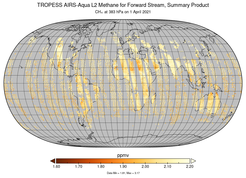
TROPESS Chemical Reanalysis HNO3 6-Hourly 3-dimensional Product V1 (TRPSCRHNO36H3D) at GES DISC
National Aeronautics and Space Administration —
The TROPESS Chemical Reanalysis HNO3 6-Hourly 3-dimensional Product contains vertical concentrations of nitric acid. The data are part of the Tropospheric Chemical... -
Federal
TES/Aura L2 Instantaneous Radiative Kernel Nadir V008
National Aeronautics and Space Administration —
TL2IRKN_8 is the Tropospheric Emission Spectrometer (TES)/Aura Level 2 Atmospheric Temperatures Limb Version 8 data product. TES was an instrument aboard NASA's Aura... -
Federal
TES/Aura L3 Ozone Monthly Gridded V006
National Aeronautics and Space Administration —
TL3O3M_6 is the Tropospheric Emission Spectrometer (TES)/Aura Level 3 Ozone (O3) Monthly Gridded Version 6 data product. TES was an instrument aboard NASA's Aura... -
Federal
TES/Aura L3 HNO3 Daily Gridded V004
National Aeronautics and Space Administration —
TL3HNOD_4 is the Tropospheric Emission Spectrometer (TES)/Aura Level 2 Atmospheric Temperatures Limb Version 4 data product. TES was an instrument aboard NASA's Aura... -
Federal
TES/Aura L2 Deuterium Oxide Nadir Special Observation V008
National Aeronautics and Space Administration —
TL2HDONS_8 is the Tropospheric Emission Spectrometer (TES)/Aura Level 2 Deuterium Oxide Nadir Special Observation Version 8 data product. TES was an instrument aboard... -
Federal
TES/Aura L2 Ammonia Nadir V008
National Aeronautics and Space Administration —
TL2NH3N_8 is the Tropospheric Emission Spectrometer (TES)/Aura Level 2 Ammonia Nadir Version 8 data product. TES was an instrument aboard NASA's Aura satellite and... -
Federal
SWOT Simulated Level-2 Nadir SSH from GLORYS for Science Version 1
National Aeronautics and Space Administration —
This dataset provides simulated sea surface height (SSH) in a format similar to the future SWOT Level 2 (L2) altimetry data from the Poseidon 3C nadir altimeter. The... -
Federal
SWOT 2019-2020 Prelaunch Oceanography Field Campaign SIO Mooring WireWalker (WW)
National Aeronautics and Space Administration —
This dataset provides the conductivity, temperature and depth (CTD) measurements from the CTD sensors on a WireWalker profiler on a full-depth mooring deployed by the... -
Federal
SWOT Level 2 Nadir Altimeter Geophysical Data Record with Waveforms
National Aeronautics and Space Administration —
The SWOT Level 2 Nadir Altimeter Geophysical Data Record (GDR) with Waveforms dataset produced by the Surface Water and Ocean Topography (SWOT) mission provides sea... -
Federal
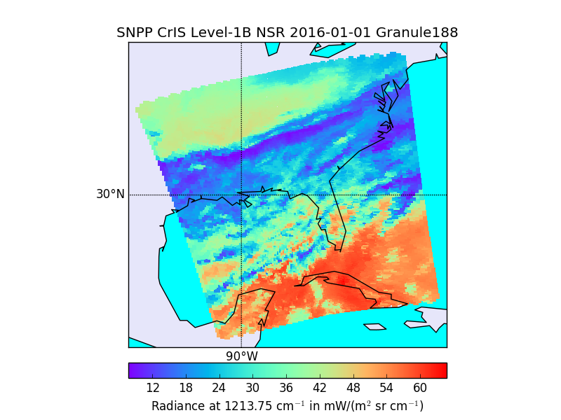
Sounder SIPS: Suomi NPP CrIMSS Level 2 CLIMCAPS Normal Spectral Resolution: Atmosphere cloud and surface geophysical state V2 (SNDRSNIML2CCPRETN) at GES DISC
National Aeronautics and Space Administration —
WARNING: To users of the derived product “co_mmr_midtrop” (carbon monoxide mass mixing ratio to dry air [kg/kg] at ~500 hPa). This variable has a significant bias due... -
Federal
Sounder SIPS: JPSS-1 CrIS Level 3 Specific Quality Control Gridded Daily CLIMCAPS V2 (SNDRJ1IML3SDCCP) at GES DISC
National Aeronautics and Space Administration —
WARNING: To users of the derived product “co_mmr_midtrop” (carbon monoxide mass mixing ratio to dry air [kg/kg] at ~500 hPa). This variable has a significant bias due...

Official websites use .gov
A
.gov website belongs to an official government
organization in the United States.
Secure .gov websites use HTTPS
A
lock (
) or https:// means you’ve safely connected to
the .gov website. Share sensitive information only on official,
secure websites.