
-
Federal
ISLSCP II Total Plant-Available Soil Water Storage Capacity of the Rooting Zone
National Aeronautics and Space Administration —
This data set provides two estimates of the geographic distribution of the total plant-available soil water storage capacity of the rooting zone ("rooting zone water... -
Federal
Kennebec River Plume - Gulf of Maine ecosystem measurements
National Aeronautics and Space Administration —
Measurements made in the Gulf of Maine between 2005 and 2007. -
Federal
GEDI L4A Footprint Level Aboveground Biomass Density, Version 2
National Aeronautics and Space Administration —
This dataset contains Global Ecosystem Dynamics Investigation (GEDI) Level 4A (L4A) Version 2 predictions of the aboveground biomass density (AGBD; in Mg/ha) and... -
Federal
NACP Site: Terrestrial Biosphere Model Output Data in Original Format
National Aeronautics and Space Administration —
This data set contains the original model output data submissions from the 24 terrestrial biosphere models (TBM) that participated in the North American Carbon... -
Federal
Scanning Multichannel Microwave Radiometer (SMMR) Monthly Mean Integrated Water Vapor (IWV) By Prabhakara
National Aeronautics and Space Administration —
SMMR_IWV_PRABHAKARA data are Special Multichannel Microwave Radiometer (SMMR) Monthly Mean Integrated Water Vapor (IWV) data by Prabhakara.The Scanning Multichannel... -
Federal
GeoEye-1 Level 1B Multispectral 4-Band Satellite Imagery
National Aeronautics and Space Administration —
The GeoEye-1 Level 1B Multispectral 4-Band L1B Satellite Imagery collection contains satellite imagery acquired from Maxar Technologies (formerly known as... -
Federal
G-LiHT Lidar Point Cloud V001
National Aeronautics and Space Administration —
Goddard’s LiDAR, Hyperspectral, and Thermal Imager (G-LiHT) mission is a portable, airborne imaging system that aims to... -
Federal
TOVS GLA 5 DAY GRIDS from NOAA-12 V01 (TOVSA5ND) at GES DISC
National Aeronautics and Space Administration —
This dataset (TOVSA5ND) contains the TIROS Operational Vertical Sounder (TOVS) level 3 geophysical parameters derived using data from NOAA-12 and the physical... -
Federal
Modeled Active-Layer Depth in Russia, Version 1
National Aeronautics and Space Administration —
This data set contains modeled active-layer depth (cm) from 50 deg N to 80 deg N, and 60 deg E to 160 deg E, Russia. Depth values are calculated from a model of... -
Federal
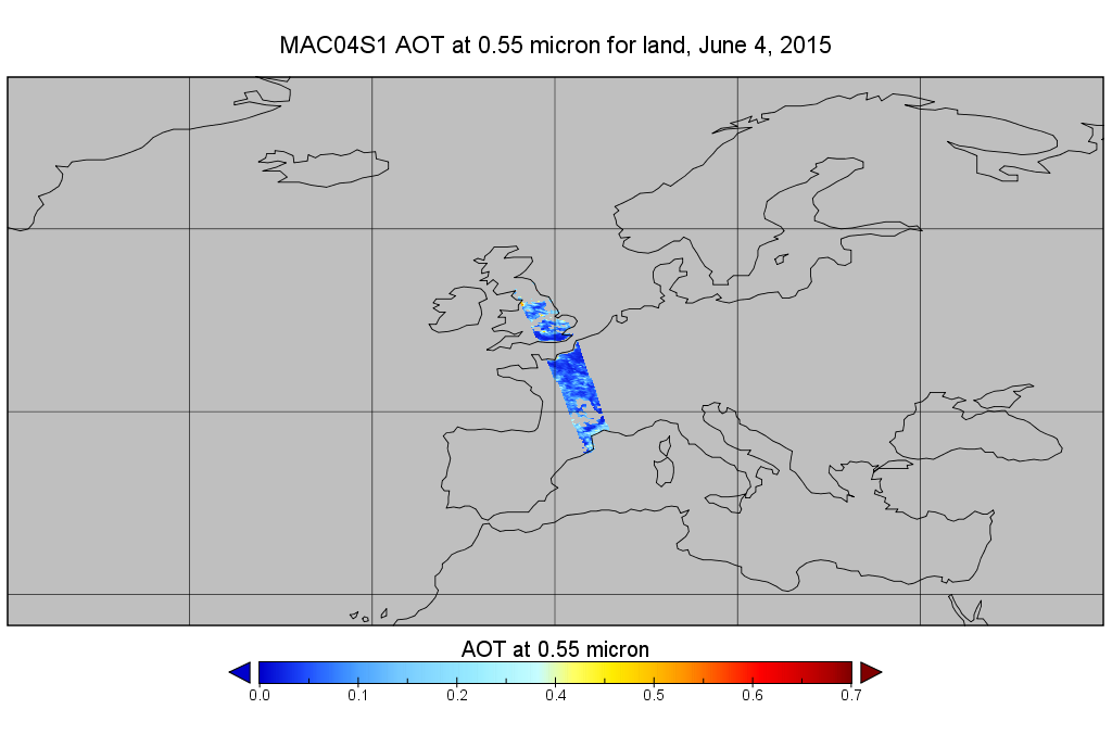
MODIS/Aqua Aerosol 10km 5-Min L2 Wide Swath Subset along CloudSat V002 (MAC04S1) at GES DISC
National Aeronautics and Space Administration —
This is the wide-swath MODIS/Aqua subset along CloudSat field of view track. The goal of the wide-swath subset is to select and return MODIS data that are within... -
Federal
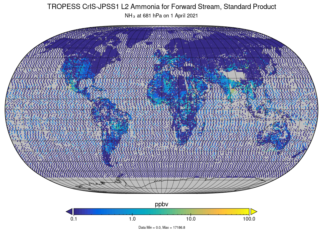
TROPESS CrIS-JPSS1 L2 Ammonia for Forward Stream, Standard Product V1 (TRPSDL2NH3CRS1FS) at GES DISC
National Aeronautics and Space Administration —
The TROPESS CrIS-JPSS1 L2 Ammonia for Forward Stream, Standard Product contains the vertical distribution of the retrieved atmospheric state of ammonia (NH3), formal... -
Federal
SENTINEL-1A_RAW
National Aeronautics and Space Administration —
Sentinel-1A level zero product -
Federal
FLDAS Noah Land Surface Model L4 Global Monthly 0.1 x 0.1 degree (MERRA-2 and CHIRPS) V001 (FLDAS_NOAH01_C_GL_M) at GES DISC
National Aeronautics and Space Administration —
This dataset contains a series of land surface parameters simulated from the Noah 3.6.1 model in the Famine Early Warning Systems Network (FEWS NET) Land Data... -
Federal
Radiosonde Data: NOAA (FIFE)
National Aeronautics and Space Administration —
The NOAA Radiosonde Observations Data Set contains data that were extracted from the NOAA operational analysis system and transmitted to the FIS. Data are available... -
Federal
GOES-R Geostationary Lightning Mapper (GLM) Gridded Data Products
National Aeronautics and Space Administration —
The GOES-R Geostationary Lightning Mapper (GLM) Gridded Data Products consist of full disk extent gridded lightning flash data collected by the Geostationary... -
Federal
TROPESS CrIS-SNPP L2 for Delhi Megacity, Standard Product V1 (TRPSDL2ALLCRSMGDEL) at GES DISC
National Aeronautics and Space Administration —
The TROPESS CrIS-SNPP L2 for Delhi Megacity, Standard Product contains the vertical distribution of seven retrieved atmospheric gases (CH4, CO, H2O, HDO, NH3, O3 and... -
Federal
Voyager 1 Heliosphere Plasma Science (PLS) Solar Wind Plasma, Hourly Data
National Aeronautics and Space Administration —
- Data Set Overview\n =================\n\nVoyager 1 Plasma Data of the Solar Wind, 1 h Averages. The Files in this Directory contain the Voyager hourly...
-
Federal
CERES Single Scanner Footprint (SSF) TOA/Surface Fluxes, Clouds and Aerosols Aqua-FM3 Edition4A
National Aeronautics and Space Administration —
CER_SSF_Aqua-FM3-MODIS_Edition4A is the Clouds and the Earth's Radiant Energy System (CERES) Single Scanner Footprint (SSF) Top-of-the-Atmosphere (TOA)/Surface... -
Federal
Jaeger Monthly Mean Global Precipitation Climatology 2.5 x 5.0 degree V1 (RAIN_JEAGER) at GES DISC
National Aeronautics and Space Administration —
The Jaeger Surface Rain Gauge Observations data set consists of gridded mean monthly global precipitation values for 1931 to 1960 over the continents and 1955 to 1965... -
Federal
TROPESS CrIS-SNPP L2 for Mexico City Megacity, Standard Product V1 (TRPSDL2ALLCRSMGMEX) at GES DISC
National Aeronautics and Space Administration —
The TROPESS CrIS-SNPP L2 for Mexico City Megacity, Standard Product contains the vertical distribution of seven retrieved atmospheric gases (CH4, CO, H2O, HDO, NH3,...

Official websites use .gov
A
.gov website belongs to an official government
organization in the United States.
Secure .gov websites use HTTPS
A
lock (
) or https:// means you’ve safely connected to
the .gov website. Share sensitive information only on official,
secure websites.