
-
Federal
SMEX02 AMSR-E Level 3 Daily Gridded Brightness Temperatures, Iowa, Version 1
National Aeronautics and Space Administration —
This data set contains Advanced Microwave Scanning Radiometer - Earth Observing System (AMSR-E) level 3 daily gridded brightness temperatures, spatially subsetted to... -
Federal
SMEX03 Geolocation Information: Georgia, Version 1
National Aeronautics and Space Administration —
Notice to Data Users: The documentation for this data set was provided solely by the Principal Investigator(s) and was not further developed, thoroughly reviewed, or... -
Federal
LBA-ECO CD-06 Soil Classification Map, Ji-Parana River Basin, Rondonia, Brazil
National Aeronautics and Space Administration —
This data set provides a digital map of soil orders for the Ji-Parana River Basin, in the state of Rondonia, Brazil (Western Amazonia). Soil orders were manually... -
Federal
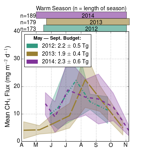
CARVE: Ecosystem Scale CH4 Emission Derived from Aircraft Observations 2012-2014
National Aeronautics and Space Administration —
This dataset provides methane flux estimates derived from airborne measurements collected over Alaska and the western Yukon Territory during the Carbon in Arctic... -
Federal
ISLSCP II Monthly Snow-Free Albedo, 1982-1998, and Background Soil Reflectance
National Aeronautics and Space Administration —
This data set contains monthly average snow-free surface shortwave albedo calculated for the period 1982-1998 and estimates of background soil/litter reflectances in... -
Federal
ISLSCP II Total Plant-Available Soil Water Storage Capacity of the Rooting Zone
National Aeronautics and Space Administration —
This data set provides two estimates of the geographic distribution of the total plant-available soil water storage capacity of the rooting zone ("rooting zone water... -
Federal
SMEX04 Soil Characteristics Data: Arizona, Version 1
National Aeronautics and Space Administration —
Notice to Data Users: The documentation for this data set was provided solely by the Principal Investigator(s) and was not further developed, thoroughly reviewed, or... -
Federal
LINKAGES: An Individual-based Forest Ecosystem Biogeochemistry Model
National Aeronautics and Space Administration —
This model product contains the source codes for version 1 of the individual-based forest ecosystem biogeochemistry model LINKAGES and two subsequent versions as well... -
Federal
Landsat-Derived Global Irrigated-Cropland Product L2 2020 30 m V002
National Aeronautics and Space Administration —
The Landsat-Derived Global Irrigated-Cropland Product Level 2 2020 (LGRIP30_L2_IRRI) Version 2 data provides high-resolution, 30 meter (m) cropland data to assist and... -
Federal
NARSTO EPA Supersite (SS) Los Angeles Harvard/EPA Annular Denuder System (HEADS) Data
National Aeronautics and Space Administration —
NARSTO_EPA_SS_LOS_ANGELES_HEADS_PART_IONS_MASS is the North American Research Strategy for Tropospheric Ozone (NARSTO) Environmental Protection Agency (EPA) Supersite... -
Federal
GPM Ground Validation USDA ARS Soil Moisture IFloodS V1
National Aeronautics and Space Administration —
The GPM Ground Validation United States Department of Agriculture (USDA) Agricultural Research Service (ARS) Soil Moisture IFloodS dataset was collected during the... -
Federal
ATP3 Unified Field Study Data
Department of Energy —
ATP3 Unified Field Study DataThe Algae Testbed Public-Private Partnership ATP3 was established with the goal of investigating open pond algae cultivation across... -
Federal
NCA-LDAS Noah-3.3 Land Surface Model L4 Trends 0.125 x 0.125 degree V2.0 (NCALDAS_NOAH0125_Trends) at GES DISC
National Aeronautics and Space Administration —
The National Climate Assessment - Land Data Assimilation System, or NCA-LDAS, is a terrestrial water reanalysis in support of the United States Global Change Research... -
Federal
BDSNP Module for Improved Soil NO Emission Estimates for CMAQ Model, Conterminous USA
National Aeronautics and Space Administration —
This model product provides: (1) the source code for the updated Berkeley-Dalhousie Soil Nitric Oxide (NO) Parameterization module (BDSNP, Version 1.0) as implemented... -
Federal
SMEX03 Land Use Classification Data: Georgia, Version 1
National Aeronautics and Space Administration —
This data set is a subset of data acquired from the United States Geological Survey's (USGS) National Land Cover Dataset (NLCD). The NLCD is comprised of Landsat data... -
Federal
Reference Site Condition Datasets for Floating Wind Arrays in the United States
Department of Energy —
Floating offshore wind farm design is highly site-specific, requiring detailed information about the specific conditions of a project area for realistic design... -
Federal
LPJ-EOSIM L2 Global Simulated Monthly Wetland Methane Flux Low Latency V001
National Aeronautics and Space Administration —
The Lund-Potsdam-Jena Earth Observation SIMulator (LPJ-EOSIM) model estimates global wetland methane (CH4) emissions using simulated wetland extent and... -
Federal
SMEX03 Geolocation Information: Oklahoma, Version 1
National Aeronautics and Space Administration —
Notice to Data Users: The documentation for this data set was provided solely by the Principal Investigator(s) and was not further developed, thoroughly reviewed, or... -
Federal
NARSTO EPA Supersite (SS) Los Angeles Tapered-Element Oscillating Microbalance (TEOM) Particulate Matter (PM) 2.5 Mass Concentration Data
National Aeronautics and Space Administration —
NARSTO_EPA_SS_LOS_ANGELES_TEOM_PM25_DATA is the North American Research Strategy for Tropospheric Ozone (NARSTO) Environmental Protection Agency (EPA) Supersite (SS)...

Official websites use .gov
A
.gov website belongs to an official government
organization in the United States.
Secure .gov websites use HTTPS
A
lock (
) or https:// means you’ve safely connected to
the .gov website. Share sensitive information only on official,
secure websites.