
-
University
1947 Dona Ana County DEY Aerial Photo Index
Earth Data Analysis Center, University of New Mexico —
Aerial photographs are retrievable on a frame by frame basis. The aerial photo inventory contains imagery from various sources that are now archived at the Earth Data... -
Baist Real Estate Atlas - 1959
District of Columbia —
The Baist Index provides a mapping index that mirrors the hardcopy index in the original Baist Map Volumes. These are real estate map scans from 1959. -
University
1935 15' Quad #038 Aerial Photo Mosaic Index
Earth Data Analysis Center, University of New Mexico —
Aerial Photo Reference Mosaics contain aerial photographs that are retrievable on a frame by frame basis. The inventory contains imagery from various sources that are... -
University
1935 15' Quad #272 Aerial Photo Mosaic Index
Earth Data Analysis Center, University of New Mexico —
Aerial Photo Reference Mosaics contain aerial photographs that are retrievable on a frame by frame basis. The inventory contains imagery from various sources that are... -
University
1935 15' Quad #077 Aerial Photo Mosaic Index
Earth Data Analysis Center, University of New Mexico —
Aerial Photo Reference Mosaics contain aerial photographs that are retrievable on a frame by frame basis. The inventory contains imagery from various sources that are... -
State
Inventory Map Index
State of Oregon —
SLIDO-4.5 is an Esri ArcGIS version 10.7 file geodatabase which can be downloaded here: https://www.oregon.gov/dogami/slido/Pages/data.aspx The geodatabase contains... -
State
Connecticut Senate Districts (2011 - 2020)
State of Connecticut —
Connecticut Senate Districts is not intended for maps printed at map scales greater or more detailed than 1:100,000 scale (1 inch = 1.578 mile). -
Federal
MODIS/Terra+Aqua Land Cover Type Yearly L3 Global 0.05Deg CMG V061
National Aeronautics and Space Administration —
The Terra and Aqua combined Moderate Resolution Imaging Spectroradiometer (MODIS) Land Cover Climate Modeling Grid (CMG) (MCD12C1) Version 6.1 data product provides a... -
Federal
Wildfire Hazard Potential, Version 2020 Continuous (Image Service)
Department of Agriculture —
Note: This Wildfire Hazard Potential (WHP) image service has been deprecated. Previous versions—including 2014, 2018, 2020, and 2023 continuous and classified... -
Federal
Oceanographic data collected during the EX2201: Mapping & ROV Shakedown expedition on NOAA Ship OKEANOS EXPLORER in the Gulf of America from 2022-02-23 to 2022-03-03 (NCEI Accession 0251689)
National Oceanic and Atmospheric Administration, Department of Commerce —
This dataset contains oceanographic data collected from NOAA Ship OKEANOS EXPLORER in the Gulf of America from 2022-02-23 to 2022-03-03. Data acquisition from... -
University
1935 15' Quad #102 Aerial Photo Mosaic Index - 2 of 2
Earth Data Analysis Center, University of New Mexico —
Aerial Photo Reference Mosaics contain aerial photographs that are retrievable on a frame by frame basis. The inventory contains imagery from various sources that are... -
Federal
BLM Natl PFYC Potential Fossil Yield Classification Geologic Formation Map Index 2022 Polygons
Department of the Interior —
Geologic formations index map. A layer that outlines the source maps compiled to make the Geologic Formations layer. It is a visual index that contains sources of map... -
Federal
Wildfire Risk to Communities Flame Length Exceedance Probability - 8 foot (Image Service)
Department of Agriculture —
The data included in this publication depict the 2024 version of components of wildfire risk for all lands in the United States that: 1) are landscape-wide (i.e.,... -
City
Vacancy Index, November 2014 (Aggregated)
City of Ferndale, Michigan —
The D3 vacancy index was designed to provide a more nuanced assessment of structural vacancy than the "occupied/unoccupied/maybe" categories used in the Motor City... -
Federal
Terrestrial Condition Assessment (TCA) Tree Mortality 6 to 10 years
Department of Agriculture —
Direct Download (Raster Data Gateway)Objective: Characterize recent impacts to terrestrial ecosystems due to outbreaks of major invasive, non-native, and native... -
Federal
BARREL 3C X-ray Spectrometer (SSPC) Bremsstrahlung X-ray Spectrum Slow Time Resolution, Level 2, 32 s Data
National Aeronautics and Space Administration —
SSPC: 256 channels of slow time resolution, 32 s, Bremsstrahlung X-ray spectra detected with a NaI Scintillator. The nominal energy range covered by the 256 channels... -
Federal
Borehole and environmental protection descriptive and numerical data, Yamal Peninsula, Russia, Version 1
National Aeronautics and Space Administration —
This database of selected borehole records from the Yamal Peninsula, Russia, contains environmental descriptions (textual and numerical) of the units on the index... -
Federal
KORUS-AQ Ozonesonde Data
National Aeronautics and Space Administration —
KORUSAQ_Sondes_Data features data collected via ozonesonde launches at Olympic Park and Taehwa during the KORUS-AQ field campaign. Data collection for this product is... -
Federal
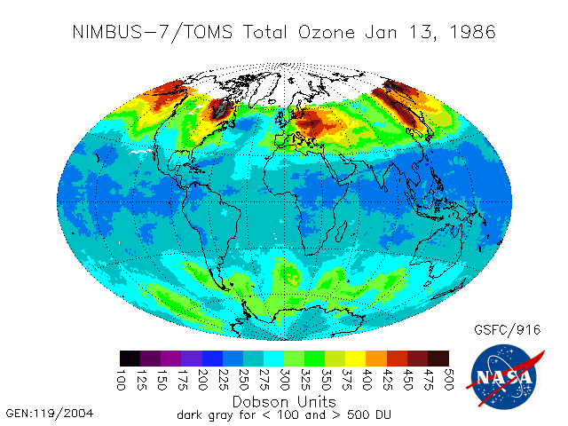
TOMS Nimbus-7 Total Ozone Aerosol Index UV-Reflectivity UV-B Erythemal Irradiances Daily L3 Global 1 deg x 1.25 deg V008 (TOMSN7L3) at GES DISC
National Aeronautics and Space Administration —
The Nimbus-7 Total Ozone Mapping Spectrometer (TOMS) version 8 daily global gridded data product contains total column ozone, UV aerosol index, Lambertian effective... -
Federal
Last of the Wild Project, Version 2, 2005 (LWP-2): Global Human Footprint Dataset (Geographic)
National Aeronautics and Space Administration —
The Global Human Footprint Dataset of the Last of the Wild Project, Version 2, 2005 (LWP-2) is the Human Influence Index (HII) normalized by biome and realm. The HII...

Official websites use .gov
A
.gov website belongs to an official government
organization in the United States.
Secure .gov websites use HTTPS
A
lock (
) or https:// means you’ve safely connected to
the .gov website. Share sensitive information only on official,
secure websites.