
-
Federal
NOAA TIFF Image - 2m Multibeam Bathymetry, W00217 USVI 2011, Seafloor Characterization of the US Caribbean - Nancy Foster - NF-11-1 (2011), UTM 20N NAD83
National Oceanic and Atmospheric Administration, Department of Commerce —
This dataset contains a GeoTIFF with 2x2 meter cell size representing the bathymetry of a broad portion of seafloor south of St. Thomas, USVI, derived from data... -
Federal
AFSC/RACE/SAP: Small Mesh Survey Data
National Oceanic and Atmospheric Administration, Department of Commerce —
This database contains information about shrimp surveys conducted by the National Marine Fisheries Service and the Alaska Department of Fish and Game in the Gulf of... -
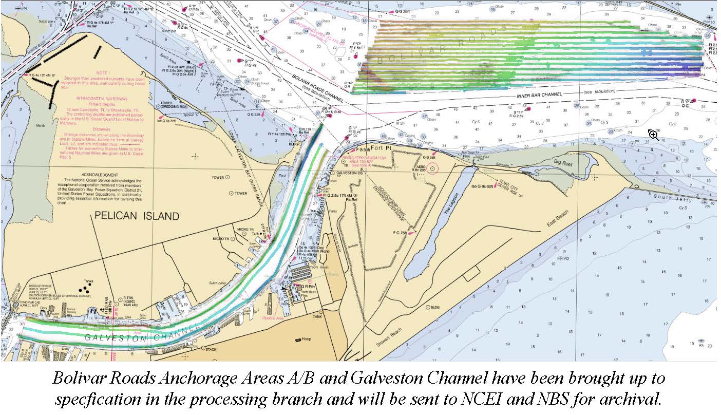
Federal
F00783: NOS Hydrographic Survey , 2019-08-13
National Oceanic and Atmospheric Administration, Department of Commerce —
The National Oceanic and Atmospheric Administration (NOAA) has the statutory mandate to collect hydrographic data in support of nautical chart compilation for safe... -
Federal
2006 Multibeam Mapping of cross-shelf corridor, North of Madison-Swanson - Florida
National Oceanic and Atmospheric Administration, Department of Commerce —
This disk or set of disks contain high-resolution multibeam and backscatter maps of an area North of Madison-Swanson (29.1667N, 85.6667W), in the West-Florida shelf,... -
Federal
La Parguera, Puerto Rico (2001 - Present) and Guanica, Puerto Rico (2011) benthic habitat assessment and monitoring data: 2011
National Oceanic and Atmospheric Administration, Department of Commerce —
This fish and benthic composition database is the result of a multifaceted effort described below. The intent of this work is five fold: 1) To spatially characterize... -
Federal
NOAA TIFF Image - 3m Bathymetry Slope, Florida Deep Coral Areas - Lost Coast Explorer - (2010), UTM 17N NAD83
National Oceanic and Atmospheric Administration, Department of Commerce —
This dataset contains a unified GeoTiff with 3x3 meter cell size representing the slope (in degrees) of several deep coral priority areas off the Atlantic Coast of... -
Federal
Ichthyoplankton Abundance and Distribution Model within the Gulf of Maine from Cape Sable, Nova Scotia to southern Massachusetts
National Oceanic and Atmospheric Administration, Department of Commerce —
The National Marine Fisheries Service's Northeast Fisheries Science Center conducted standardized ichthyoplankton surveys from 1977-1988 along the continental shelf... -
Federal
National Status and Trends: Bioeffects Program - Biscayne Bay, Florida (1995-1996) Database
National Oceanic and Atmospheric Administration, Department of Commerce —
The toxicity of sediments in Biscayne Bay and many adjoining tributaries was determined as part of a bioeffects assessments program managed by NOAA's National Status... -
Federal
Digital Geologic-GIS Map of Santa Monica Mountains National Recreation Area and Vicinity, California (NPS, GRD, GRI, SAMO, SAMO digital map) adapted from California Geological Survey Preliminary Geologic Maps by Campbell, Wills, Irvine and Swanson (digital preparation by Gutierrez and O'Neal) (2014), and by Tan, Clahan and Hitchcock (digital database by Gutierrez and Mascorro) (2004), and a digital database map by Wills Campbell and Irvine (digital database by Gutierrez.and O'Neal) (2013)
Department of the Interior —
The Digital Geologic-GIS Map of Santa Monica Mountains National Recreation Area and Vicinity, California is composed of GIS data layers and GIS tables, and is... -
Federal
NOAA ESRI Geotiff - 3m Backscatter Mosaic, Puerto Rico (Isla de Vieques) - UTM 20N NAD83
National Oceanic and Atmospheric Administration, Department of Commerce —
This image represents a 3 meter resolution backscatter mosaic of selected portions of seafloor around Isla de Vieques, Puerto Rico. NOAA's NOS/NCCOS/CCFHR, in... -
Federal
H09265: NOS Hydrographic Survey , South Coast of Puerto Rico, Peurto Rico, 1972-05-22
National Oceanic and Atmospheric Administration, Department of Commerce —
The National Oceanic and Atmospheric Administration (NOAA) has the statutory mandate to collect hydrographic data in support of nautical chart compilation for safe... -
Federal
H13341: NOS Hydrographic Survey , 2020-11-13
National Oceanic and Atmospheric Administration, Department of Commerce —
The National Oceanic and Atmospheric Administration (NOAA) has the statutory mandate to collect hydrographic data in support of nautical chart compilation for safe... -
Federal
F00437: NOS Hydrographic Survey , Delaware Bay, Delaware, Vicinity of Big Stone Anchorage Area, 1997-11-17
National Oceanic and Atmospheric Administration, Department of Commerce —
The National Oceanic and Atmospheric Administration (NOAA) has the statutory mandate to collect hydrographic data in support of nautical chart compilation for safe... -
Federal
NOAA ESRI Grid - seafloor hardbottom occurrence predictions model in New York offshore planning area from Biogeography Branch
National Oceanic and Atmospheric Administration, Department of Commerce —
This dataset represents hard bottom occurrence predictions from a spatial model developed for the New York offshore spatial planning area. This model builds upon the... -
Federal
NOAA TIFF Image - 30m Backscatter, South Atlantic Bight - Deep Coral Priority Areas - Navy Pathfinder - (2003), UTM 17N NAD83
National Oceanic and Atmospheric Administration, Department of Commerce —
This dataset contains a unified GeoTiff with 30x30 meter cell size representing the bathymetry of several deep coral priority areas off the South Atlantic Bight,... -
Federal
NOAA TIFF Image - NF12_PR_1002_bathy_8m.tif - Benthic Habitat Characterization - NOAA Ship Nancy Foster - M-I907-NF-12 (2012), UTM 20N NAD83
National Oceanic and Atmospheric Administration, Department of Commerce —
This image represents a 4 meter resolution bathymetry of a reef shelf/bank and the steep canyons and slopes of the NE Reserve, offshore of Fajardo, Puerto Rico. The... -
Federal
NOAA ESRI Grid - depth predictions bathymetry model in New York offshore planning area from Biogeography Branch
National Oceanic and Atmospheric Administration, Department of Commerce —
This dataset represents depth predictions from a bathymetric model developed for the New York offshore spatial planning area. The model also includes spatially-... -
Federal
H09603: NOS Hydrographic Survey , Bajos Grampus and Vicinity, Virgin Islands, 1976-03-24
National Oceanic and Atmospheric Administration, Department of Commerce —
The National Oceanic and Atmospheric Administration (NOAA) has the statutory mandate to collect hydrographic data in support of nautical chart compilation for safe... -
Federal
D00230: NOS Hydrographic Survey , 2017-09-07
National Oceanic and Atmospheric Administration, Department of Commerce —
The National Oceanic and Atmospheric Administration (NOAA) has the statutory mandate to collect hydrographic data in support of nautical chart compilation for safe... -
Federal
F00653: NOS Hydrographic Survey , 2015-10-15
National Oceanic and Atmospheric Administration, Department of Commerce —
The National Oceanic and Atmospheric Administration (NOAA) has the statutory mandate to collect hydrographic data in support of nautical chart compilation for safe...

Official websites use .gov
A
.gov website belongs to an official government
organization in the United States.
Secure .gov websites use HTTPS
A
lock (
) or https:// means you’ve safely connected to
the .gov website. Share sensitive information only on official,
secure websites.