
-
Federal
Coastal Wetland Elevation and Carbon Flux Inventory with Uncertainty, USA, 2006-2011
National Aeronautics and Space Administration —
This dataset provides maps of coastal wetland carbon and methane fluxes and coastal wetland surface elevation from 2006 to 2011 at 30 m resolution for coastal... -
Federal
GHRSST NOAA/STAR GOES-17 ABI L3C America Region SST v2.71 dataset in GDS2
National Aeronautics and Space Administration —
The ACSPO G17/ABI L3C (Level 3 Collated) product is a gridded version of the ACSPO G17/ABI L2P product available at... -
Federal
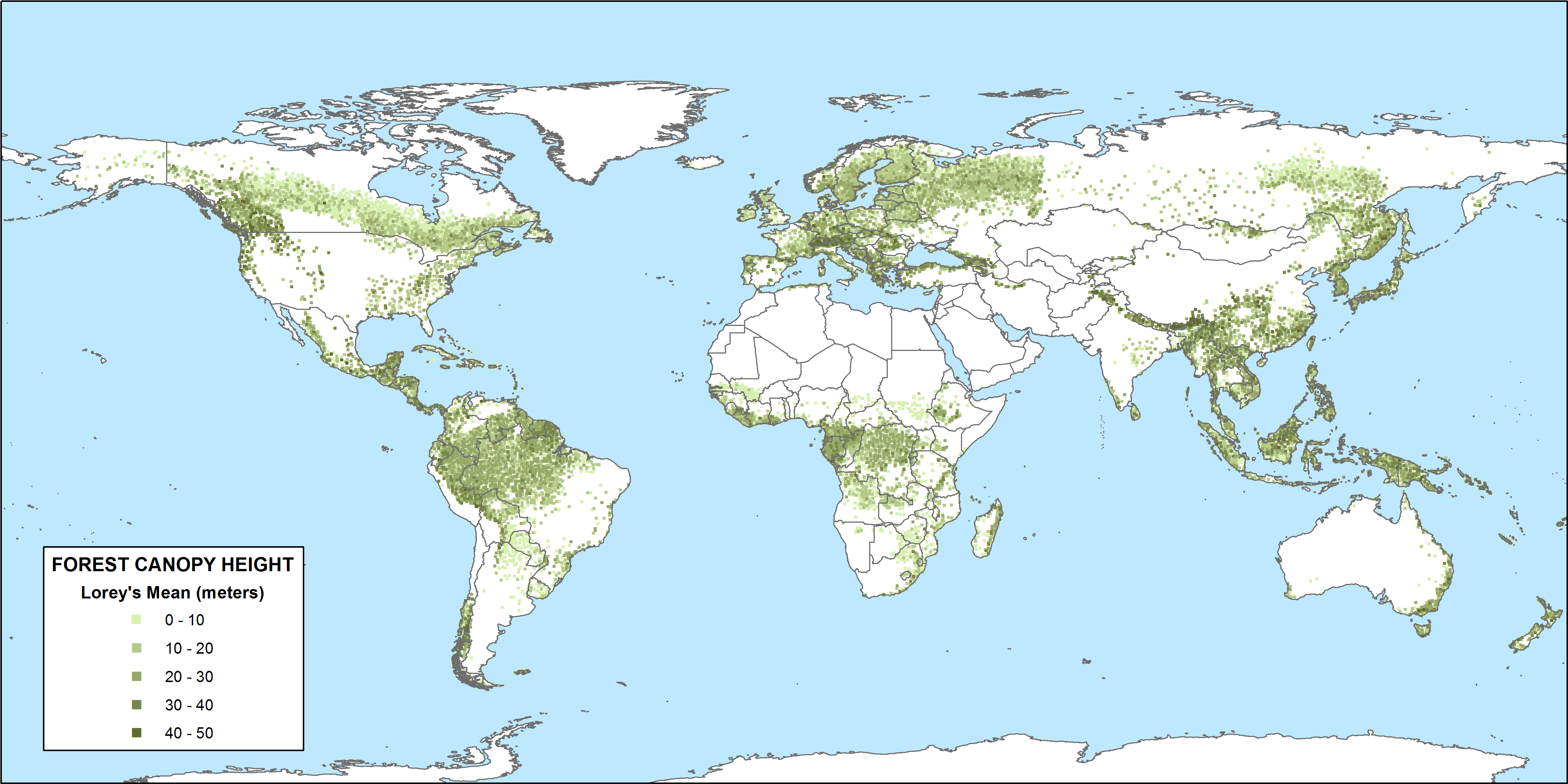
CMS: GLAS LiDAR-derived Global Estimates of Forest Canopy Height, 2004-2008
National Aeronautics and Space Administration —
This data set provides estimates of forest canopy height derived from the Geoscience Laser Altimeter System (GLAS) LiDAR instrument that was aboard the NASA Ice,... -
Federal
AMSR-E/Aqua Daily Global Quarter-Degree Gridded Brightness Temperatures, Version 1
National Aeronautics and Space Administration —
The Advanced Microwave Scanning Radiometer - Earth Observing System (AMSR-E) instrument on the NASA EOS Aqua satellite provides global passive microwave measurements... -
Federal
ASTER L1A Reconstructed Unprocessed Instrument Data V003
National Aeronautics and Space Administration —
The Advanced Spaceborne Thermal Emission and Reflection Radiometer (ASTER) Level 1A (AST_L1A) contains reconstructed, instrument digital numbers (DNs) derived from... -
Federal
VLA Goulds Belt Survey Serpens Region Source Catalog
National Aeronautics and Space Administration —
This table contains results from a deep (~17 µJy) radio continuum observations of the Serpens molecular cloud, the Serpens south cluster, and the W40 region that were... -
Federal
Aqua MODIS Level-1 Level-1 Data, version 1
National Aeronautics and Space Administration —
MODIS (or Moderate-Resolution Imaging Spectroradiometer) is a key instrument aboard the Terra (EOS AM) and Aqua (EOS PM) satellites. Terra's orbit around the Earth is... -
Federal
Spitzer Wide-area InfraRed Extragalactic Survey Lockman Hole MIPS 70 micron Catalog
National Aeronautics and Space Administration —
The Spitzer Wide-area InfraRed Extragalactic survey (SWIRE), the largest Spitzer Legacy program, is a wide-area, imaging survey to trace the evolution of dusty, star-... -
Federal
Monoceros R2 Cloud Chandra X-Ray Point Source Catalog
National Aeronautics and Space Administration —
The Monoceros R2 (Mon R2) Cloud X-Ray Point Source Catalog contains the results of the Chandra ACIS-I observation of the central region of this high-mass star-forming... -
Federal
ABoVE: Permafrost Measurements and Distribution Across the Y-K Delta, Alaska, 2016
National Aeronautics and Space Administration —
This dataset provides field observations of thaw depth and dominant vegetation types, a LiDAR-derived elevation map, and permafrost distribution and probability maps... -
Federal
Dynamical Masses of Selected Orbital Binary Systems
National Aeronautics and Space Administration —
Orbital binary stars are essential objects for determining dynamical and physical properties of stars through a combined analysis of photometric and astrometric data.... -
Federal
BOREAS TGB-08 Monoterpene Concentration Data over the SSA-OBS and the SSA-OJP
National Aeronautics and Space Administration —
The TGB-08 team collected data to investigate the controls over non-methane hydrocarbon (NMHC) fluxes from boreal forest tree species. This data set contains... -
Federal
Wind SMS Suite SupraThermal Ion Composition Spectrometer (SMS/STICS) Ion Angular Flux Maps (AFMs), Level 2 (L2), 30-minute Data in Solar Wind
National Aeronautics and Space Administration —
The data include Wind STICS 30-minute Angular Flux Maps (AFMs) for selected ion species using triple coincidence (H+, He+, He2+, C5+, O+, O6+, and Fe10+) and double... -
Federal
ISEE-3 Linearly Interpolated 60 s Resolution Solar Wind Plasma data in GSE Coordinates
National Aeronautics and Space Administration —
ISEE-3 linearly interpolated to have the measurements on the minute at 60 s resolution solar wind plasma data in GSE coordinates. This data set consists of processed... -
Federal
CLPX-Satellite: AMSR-E Brightness Temperature Grids, Version 1
National Aeronautics and Space Administration —
This data set includes Aqua Advanced Microwave Scanning Radiometer - Earth Observing System (AMSR-E) passive microwave brightness temperatures gridded to the... -
Federal
CLPX-Ground: ISA Soil Moisture Measurements, Version 1
National Aeronautics and Space Administration —
This data set consists of in-situ point measurements of soil moisture within three 25-km by 25-km Meso-cell Study Areas (MSAs) in northern Colorado (Fraser, North... -
Federal
California Current Ecosystem (CCE) - Long Term Ecological Research Network (LTER)
National Aeronautics and Space Administration —
Measurements made under the Long Term Ecological Research Network (LTER) California Current Ecosystem (CCE) program between 2006 and 2008. -
Federal
Arctic Marine Transportation Program 1979-1986, Version 1
National Aeronautics and Space Administration —
The purpose of this program was to collect data relevant to developing year-round transportation capabilities in the Arctic Ocean. The US Maritime Administration... -
Federal
BARREL 4E X-ray Spectrometer (SSPC) Bremsstrahlung X-ray Spectrum Slow Time Resolution, Level 2, 32 s Data
National Aeronautics and Space Administration —
SSPC: 256 channels of slow time resolution, 32 s, Bremsstrahlung X-ray spectra detected with a NaI Scintillator. The nominal energy range covered by the 256 channels... -
Federal
ELFIN A Energetic Particle Detectors for Ions (EPD-I) 0.264 s Data
National Aeronautics and Space Administration —
The Electron Losses and Fields Investigation (ELFIN) mission is a space weather mission using three scientific instruments in a 3U+ CubeSat. Each spacecraft has two...

Official websites use .gov
A
.gov website belongs to an official government
organization in the United States.
Secure .gov websites use HTTPS
A
lock (
) or https:// means you’ve safely connected to
the .gov website. Share sensitive information only on official,
secure websites.