
-
Federal
LBA-ECO ND-11 Litter Decomposition, Carbon, and Nitrogen Dynamics in Agroforestry
National Aeronautics and Space Administration —
It has been proposed that the C/N ratio, or quality, of litter or mulch mixtures affects N release. Although total N release from these mixtures and the effects on... -
Federal
LBA-ECO ND-11 Forest Soil Structure and Nitrate, NW Mato Grosso, Brazil: 2004-2005
National Aeronautics and Space Administration —
This data set reports the results of the analysis of soil samples for Nitrate (NO3) and physical properties that were collected for one year following reduced impact... -
Federal
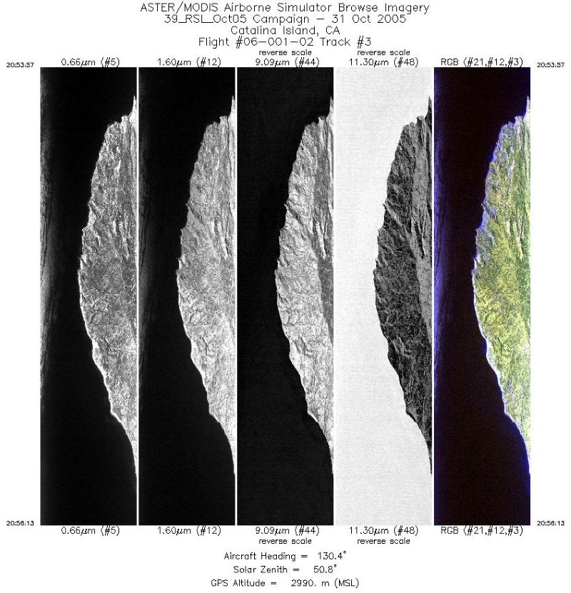
MASTER: Airborne Science, Catalina Island, California, October 2005
National Aeronautics and Space Administration —
This dataset includes Level 1B (L1B) data products from the MODIS/ASTER Airborne Simulator (MASTER) instrument. The spectral data were collected during one flight... -
Federal
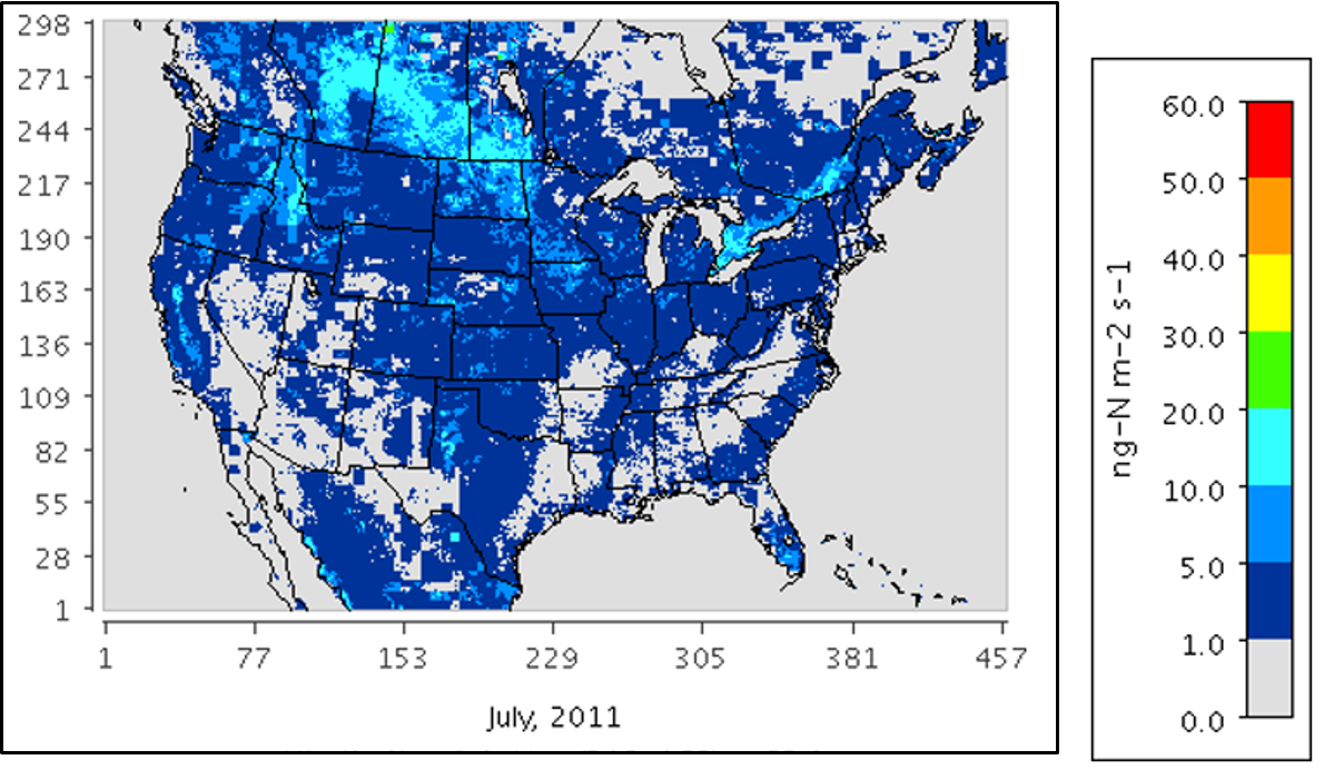
Mechanistic Module for Soil Nitrogen Emissions for CMAQ Model, North America, 2011
National Aeronautics and Space Administration —
This model product provides source code, input data files, and example model outputs for a new mechanistic soil nitrogen (N) module in-line with the Community... -
Federal
NPP Tropical Forest: San Carlos de Rio Negro, Venezuela, 1975-1984, R1
National Aeronautics and Space Administration —
This data set includes five ASCII files (.txt format). Three files contain above- and below-ground biomass and net primary productivity (NPP) data, one file for each... -
Federal
NPP Boreal Forest: Superior National Forest, USA, 1983-1984, R1
National Aeronautics and Space Administration —
This data set contains two files (.txt format). One file provides ground-based biophysical measurements and above-ground net primary productivity (ANPP) estimates for... -
Federal
VEMAP 1: U.S. Soil
National Aeronautics and Space Administration —
The Vegetation/Ecosystem Modeling and Analysis Project (VEMAP) is an ongoing multiinstitutional, international effort addressing the response of biogeography and... -
Federal
Vegetation Species Data (FIFE)
National Aeronautics and Space Administration —
The Vegetation Species and Cover Abundance Data Set documents the species present at the FIFE staff data measurement sites. Percent cover is estimated for each... -
Federal
Understory Vegetation Biomass from Selected Burned and Unburned sites in Alaska
National Aeronautics and Space Administration —
This dataset provides measurements of vegetation biomass from 11 locations across Alaska during 2016 to 2018. Vegetation was harvested from plots that were located at... -
Federal
SAFARI 2000 Surface Albedo and Radiation Fluxes at Mongu and Skukuza, 2000-2002
National Aeronautics and Space Administration —
Top-of-the-canopy broadband albedo and radiation fluxes are calculated from measurements at the Mongu and Skukuza flux tower sites in southern Africa from March 2000... -
Federal
SAFARI 2000 Surface Spectral Reflectance at Sua Pan, Botswana, Dry Season 2000
National Aeronautics and Space Administration —
The Multi-angle Imaging SpectroRadiometer (MISR) Validation team was deployed to Sua Pan, a salt playa in the Magkadigkadi region of Botswana, from August 18 to... -
Federal
SAFARI 2000 Leaf Area Index and Canopy Structure, Kalahari Transect, 1999-2000
National Aeronautics and Space Administration —
Data from the Tracing Radiation and Architecture of Canopies (TRAC) instrument were collected at five sites along the International Geosphere-Biosphere Programme... -
Federal
SAFARI 2000 Land Cover from AVHRR, 1-Deg, 1987 (Defries and Townshend)
National Aeronautics and Space Administration —
This data set consists of a southern African subset of the University of Maryland (UMD) 1-degree Global Land Cover product in ASCII GRID and binary image formats. The... -
Federal
SAFARI 2000 AERONET-derived Diffuse Spectral Irradiance for Eight Core Sites
National Aeronautics and Space Administration —
This data set contains monthly mean values of diffuse irradiance fraction [f(Ediff), or ratio of diffuse-to-total irradiance] at ground level for a 30-degree solar... -
Federal
SAFARI 2000 AERONET Ground-based Aerosol Data, Dry Season 2000
National Aeronautics and Space Administration —
AERONET (AErosol RObotic NETwork) is an optical ground-based aerosol monitoring network and data archive system. AERONET measurements of the column-integrated aerosol... -
Federal
SAFARI 2000 Annual Soil Respiration Data (Raich and Schlesinger 1992)
National Aeronautics and Space Administration —
The data set consists of a southern African subset of the "Global Annual Soil Respiration Data (Raich and Schlesinger 1992)" data set. The data file is in ASCII text... -
Federal
SAFARI 2000 Kalahari Transect CO2, Water Vapor, and Heat Flux, Wet Season 2000
National Aeronautics and Space Administration —
Short-term measurements of carbon dioxide, water, and energy fluxes were collected at four locations along a mean annual precipitation gradient in southern Africa...

Official websites use .gov
A
.gov website belongs to an official government
organization in the United States.
Secure .gov websites use HTTPS
A
lock (
) or https:// means you’ve safely connected to
the .gov website. Share sensitive information only on official,
secure websites.