
-
State
Song Sparrow Range - CWHR B505 [ds901]
State of California —
Vector datasets of CWHR range maps are one component of California Wildlife Habitat Relationships (CWHR), a comprehensive information system and predictive model for... -
University
Clovis 1:100000 Quado Hydrography DLGs
Earth Data Analysis Center, University of New Mexico —
Digital line graph (DLG) data are digital representations of cartographic information. DLG's of map features are converted to digital form from maps and related... -
Federal
MMS 3 Digital Signal Processor (DSP) Double Probe (ADP, SDP), Electric Field Power Spectral Density, Level 2 (L2), Slow Mode, 16 s Data
National Aeronautics and Space Administration —
The MMS electric field power spectral density (EPSD) is computed onboard by the Digital Signal Processor (DSP). The fast Fourier transform (FFT) calculation is... -
Federal
MMS 3 Digital Signal Processor (DSP) Double Probe (ADP, SDP), Electric Field Power Spectral Density, Level 2 (L2), Fast Mode, 2 s Data
National Aeronautics and Space Administration —
The MMS electric field power spectral density (EPSD) is computed onboard by the Digital Signal Processor (DSP). The fast Fourier transform (FFT) calculation is... -
Federal
MMS 4 Digital Signal Processor (DSP) Double Probe (ADP, SDP), Electric Field Power Spectral Density, Level 2 (L2), Fast Mode, 2 s Data
National Aeronautics and Space Administration —
The MMS electric field power spectral density (EPSD) is computed onboard by the Digital Signal Processor (DSP). The fast Fourier transform (FFT) calculation is... -
Federal
MMS 4 Digital Signal Processor (DSP) Double Probe (ADP, SDP), Electric Field Power Spectral Density, Level 2 (L2), Slow Mode, 16 s Data
National Aeronautics and Space Administration —
The MMS electric field power spectral density (EPSD) is computed onboard by the Digital Signal Processor (DSP). The fast Fourier transform (FFT) calculation is... -
Federal
Global Gridded Surfaces of Selected Soil Characteristics (IGBP-DIS)
National Aeronautics and Space Administration —
The Global Gridded Surfaces of Selected Soil Characteristics (IGBP-DIS) data set contains 7 data surfaces: soil-carbon density, total nitrogen density, field... -
Federal
LBA-ECO LC-24 Cadastral Property Map of Uruara, Para, Brazil: ca.1975
National Aeronautics and Space Administration —
This data set contains a shapefile of a digitized map of the land parcel information of the original properties of the Uruara colonization site, Para, Brazil,... -
Federal
DE 2 Vector Electric Field Instrument, VEFI, Magnetometer, MAG-B, Merged Magnetic and Electric Field Parameters, 62 ms Data
National Aeronautics and Space Administration —
This Dynamics Explorer 2, DE 2, data set is a combination of the Vector Electric Field Instrument, VEFI, and Magnetometer-B, MAGB, high resolution data sets in... -
Federal
MMS 1 Digital Signal Processor (DSP) Double Probe (ADP, SDP), Electric Field Power Spectral Density, Level 2 (L2), Fast Mode, 2 s Data
National Aeronautics and Space Administration —
The MMS electric field power spectral density (EPSD) is computed onboard by the Digital Signal Processor (DSP). The fast Fourier transform (FFT) calculation is... -
Federal
MMS 2 Digital Signal Processor (DSP) Double Probe (ADP, SDP), Electric Field Power Spectral Density, Level 2 (L2), Fast Mode, 2 s Data
National Aeronautics and Space Administration —
The MMS electric field power spectral density (EPSD) is computed onboard by the Digital Signal Processor (DSP). The fast Fourier transform (FFT) calculation is... -
Federal
R-Factor for the Island of Molokai
National Oceanic and Atmospheric Administration, Department of Commerce —
The rainfall-runoff erosivity factor (R-Factor) quantifies the effects of raindrop impacts and reflects the amount and rate of runoff associated with the rain. The... -
Federal
R-Factor for the Island of Hawaii
National Oceanic and Atmospheric Administration, Department of Commerce —
The rainfall-runoff erosivity factor (R-Factor) quantifies the effects of raindrop impacts and reflects the amount and rate of runoff associated with the rain. The... -
Federal
Digital Elevation Models for the Global Change Research Wetland, Maryland, USA, 2016
National Aeronautics and Space Administration —
This dataset contains four alternative digital elevation models (DEMs) at 1 m resolution and model performance statistical metrics for the Global Change Research... -
Federal
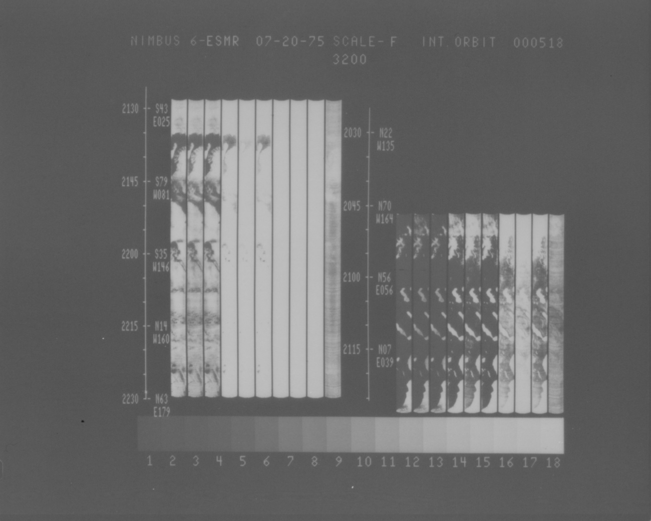
ESMR/Nimbus-6 Images of Brightness Temperature on 70 mm Film V001 (ESMRN6IM) at GES DISC
National Aeronautics and Space Administration —
ESMRN6IM is the Nimbus-6 Electrically Scanning Microwave Radiometer (ESMR) data product containing daily brightness temperature images from 70-mm photofacsimile film... -
Federal
LBA-ECO ND-11 Pre-harvest Forest Tree and Liana Biomass, NW Mato Grosso, Brazil: 2003
National Aeronautics and Space Administration —
The purpose of this study was to determine if spatially-explicit commercial timber inventories (CTI) could be used in conjunction with satellite imagery to improve... -
Federal
LBA-ECO ND-04 Secondary Forest Recovery, Structure, and LAI, Central Amazonia, Brazil
National Aeronautics and Space Administration —
This data set reports measurements of the canopy and structure of secondary forests regenerating from abandoned pastures. These secondary forests are located in the... -
Federal
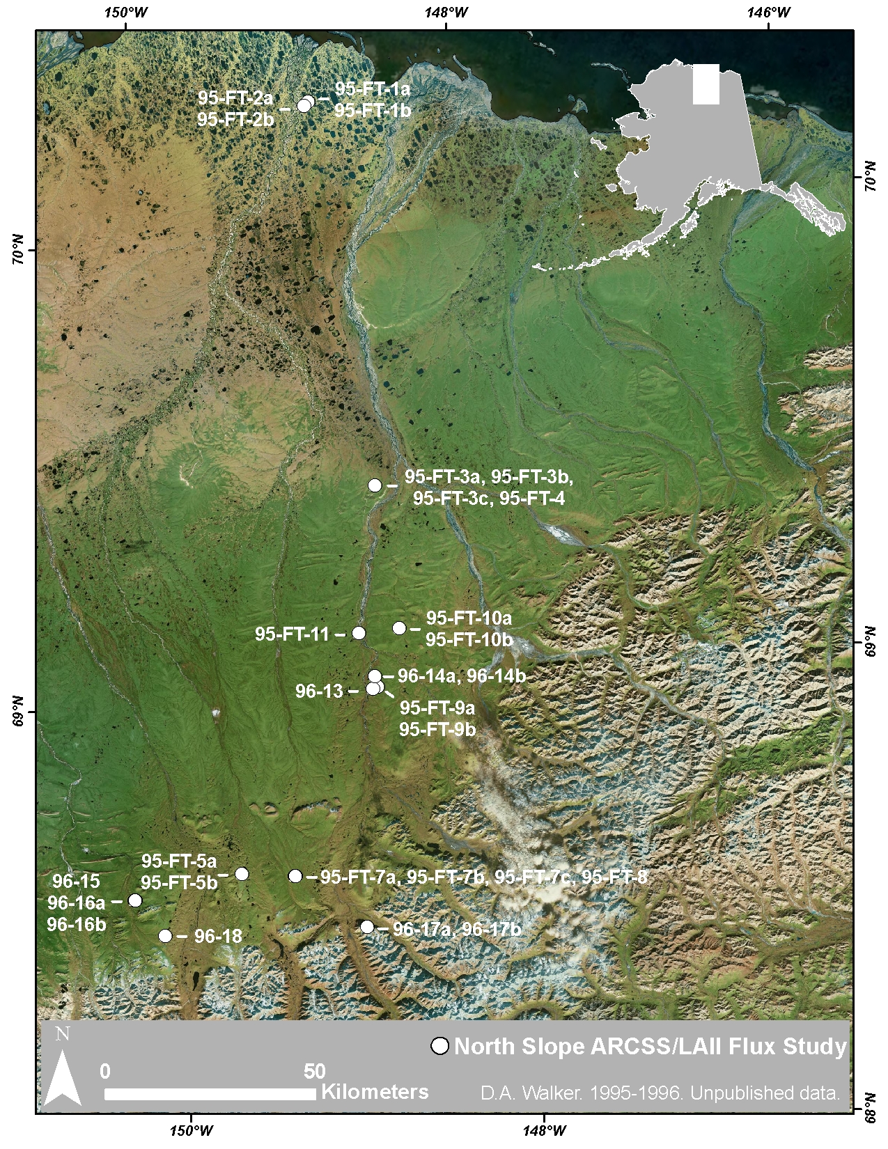
Arctic Vegetation Plots at ARCSS/LAII Flux Sites, North Slope, Alaska, 1995-1996
National Aeronautics and Space Administration —
This dataset provides vegetation cover and environmental plot and soil data collected at flux tower sites of the North Slope Arctic System Science/Land-Atmosphere-Ice... -
Federal
Australia Telescope-PMN Catalog of Southern Radio Sources
National Aeronautics and Space Administration —
This table contains a source catalog of 9040 radio sources derived from high-resolution observations of a selection of 8385 Parkes-MIT-NRAO (PMN) sources made with... -
Federal
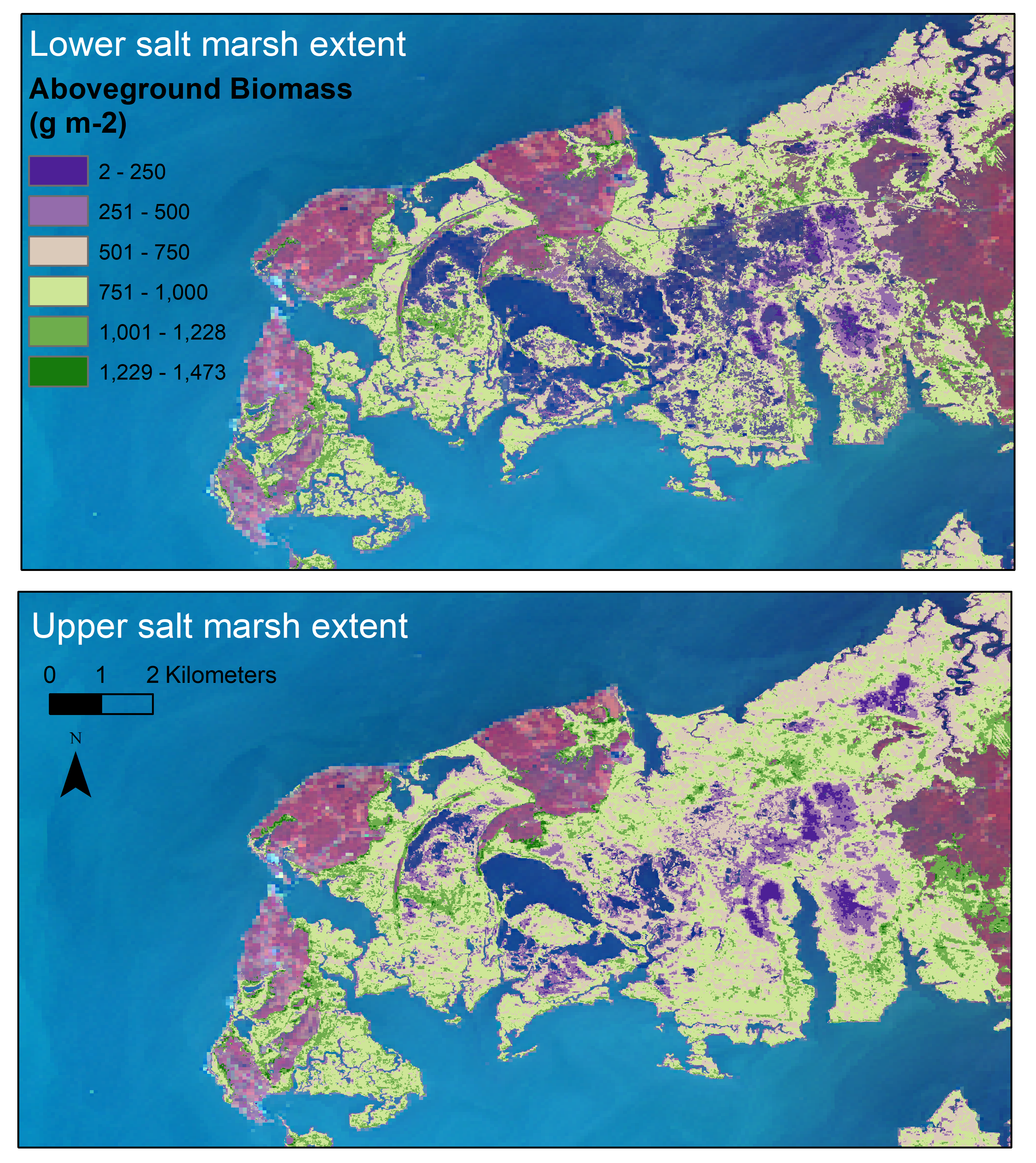
Aboveground Biomass Estimates for Salt Marsh for the Contiguous United States, 2020
National Aeronautics and Space Administration —
This dataset provides estimates of aboveground biomass (AGB) and salt marsh extent in the contiguous United States for 2020 and includes all coastal watersheds across...

Official websites use .gov
A
.gov website belongs to an official government
organization in the United States.
Secure .gov websites use HTTPS
A
lock (
) or https:// means you’ve safely connected to
the .gov website. Share sensitive information only on official,
secure websites.