
-
Federal
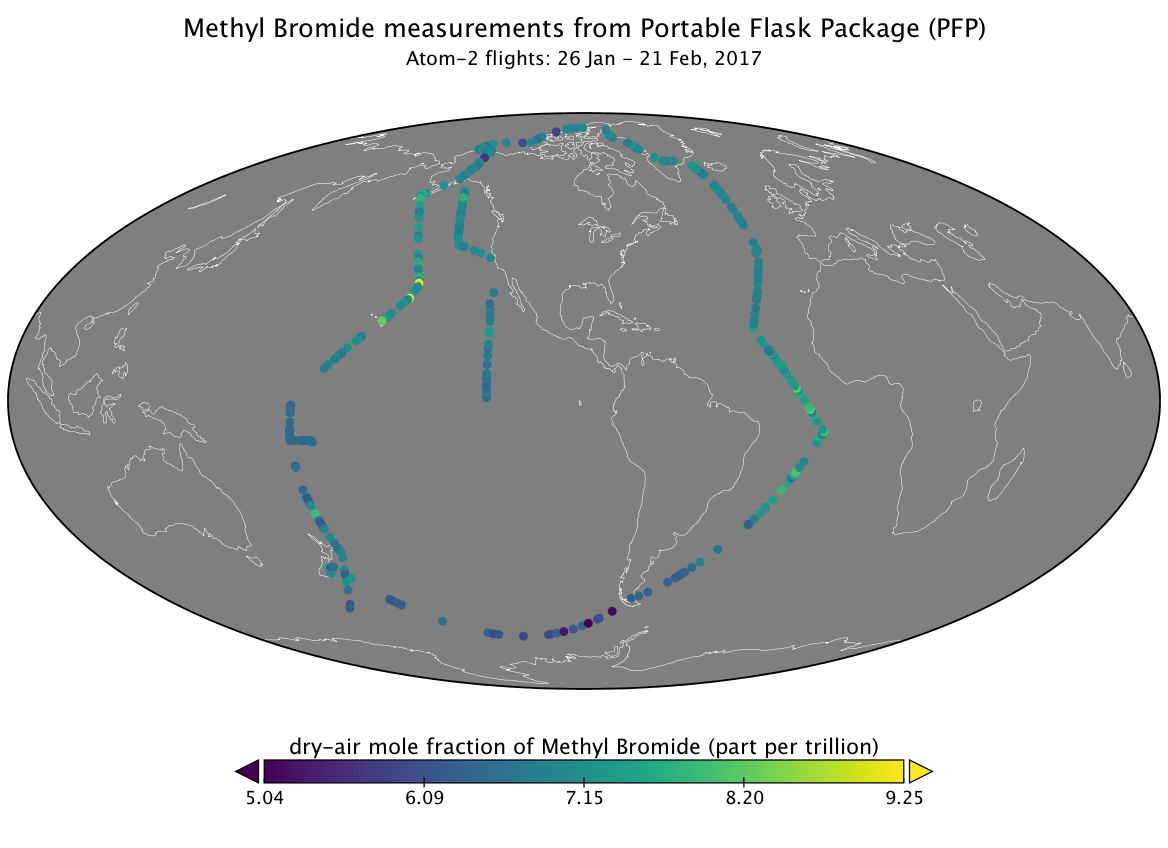
ATom: L2 Measurements from the Programmable Flask Package (PFP) Whole Air Sampler
National Aeronautics and Space Administration —
This dataset provides mole fractions of atmospheric trace gases measured by the Programmable Flask Package (PFP) Whole Air Sampler during airborne campaigns conducted... -
Federal
Aquarius Official Release Level 3 Sea Surface Salinity Standard Mapped Image 28-Day Running Mean Data V5.0
National Aeronautics and Space Administration —
Aquarius Level 3 sea surface salinity (SSS) standard mapped image data containsgridded 1 degree spatial resolution SSS averaged over daily, 7 day, monthly, and... -
Federal
BOREAS TF-02 SSA-OA Tower Flux, Meteorological, and Precipitation Data
National Aeronautics and Space Administration —
The BOREAS TF-02 team collected energy, carbon dioxide, water vapor, and momentum flux data above the canopy and in profiles through the canopy, along with... -
Federal
BOREAS TF-04 CO2 and CH4 Chamber Flux Data from the SSA
National Aeronautics and Space Administration —
The BOREAS TF-04 team measured fluxes of carbon dioxide (CO2) and methane (CH4) across the soil-air interface in four ages of jack pine forest at the Southern Study... -
Federal
BOREAS TE-23 Canopy Architecture and Spectral Data from Hemispherical Photos
National Aeronautics and Space Administration —
The BOREAS TE-23 team collected hemispherical photographs in support of its efforts to characterize and interpret information on estimates of canopy architecture and... -
Federal
BOREAS AFM-05 Level-2 Upper Air Network Standard Pressure Level Data
National Aeronautics and Space Administration —
The BOREAS AFM-05 team collected and processed data from the numerous radiosonde flights during the project. The goals of the AFM-05 team were to provide large scale... -
Federal
Aquarius Official Release Level 3 Sea Surface Spiciness Standard Mapped Image Mission Cumulative Data V5.0
National Aeronautics and Space Administration —
Aquarius Level 3 sea surface spiciness standard mapped image data contains gridded 1 degree spatial resolution spice data averaged over daily, 7day, monthly, and... -
Federal
CARAFE: Regional Airborne Greenhouse Gases Eddy Covariance Measurements, 2016-2017
National Aeronautics and Space Administration —
This dataset provides airborne eddy covariance (EC) fluxes of carbon dioxide, methane, sensible heat, and latent heat at high spatial resolution collected during the... -
Federal
BOREAS TGB-05 CO2, CH4, and CO Chamber Flux Data over the NSA
National Aeronautics and Space Administration —
The BOREAS TGB-05 team collected a variety of trace gas concentration and flux measurements at several NSA sites. This data set contains carbon dioxide (CO2), methane... -
Federal
BOREAS TGB-04 NSA-BVP Tower Flux and Meteorological Data
National Aeronautics and Space Administration —
The BOREAS TGB-04 team measured the exchange of heat, water, and CO2 between a boreal forest beaver pond and the atmosphere in the NSA for the ice-free period of... -
Federal
BOREAS TF-11 SSA-FEN Tower Flux and Meteorological Data
National Aeronautics and Space Administration —
The BOREAS TF-11 team collected energy, carbon dioxide, and methane flux data at the BOREAS SSA-Fen site during the growing seasons of 1994 and 1995. -
Federal
BOREAS TGB-01/TGB-03 Water Table and Peat Temperature Data over the NSA
National Aeronautics and Space Administration —
The BOREAS TGB-01 and TGB-03 teams collected several data sets that contributed to understanding the measured trace gas fluxes over sites in the NSA. This data set... -
Federal
BOREAS TE-06 Biomass and Foliage Area Data
National Aeronautics and Space Administration —
The BOREAS TE-06 team collected several data sets in support of its efforts to characterize and interpret information on the plant biomass, allometry, biometry,... -
Federal
BOREAS TE-05 Surface Meteorological & Radiation Data
National Aeronautics and Space Administration —
The BOREAS group TE-05 collected measurements in the NSA and SSA on gas exchange, gas composition and tree growth. Measurements of meteorological data, including air... -
Federal
BOREAS Agriculture Canada Central Saskatchewan Vector Soils Data, R1
National Aeronautics and Space Administration —
This data set provides soil descriptions for forested areas in the BOREAS southern study area (SSA) in central Saskatchewan, Canada provided by Agriculture Canada.... -
Federal
BOREAS AFM-06 Surface Meteorological Data
National Aeronautics and Space Administration —
The BOREAS AFM-06 team from the National Oceanic and Atmospheric Administration Environment Technology Laboratory (NOAA/ETL) collected surface meteorological data... -
Federal
BOREAS AFM-06 Mean Wind Profile Data
National Aeronautics and Space Administration —
The BOREAS AFM-06 team from the National Oceanic and Atmospheric Administration Environment Technology Laboratory (NOAA/ETL) operated a 915 MHz wind/Radio Acoustic... -
Federal
ATom: L2 In Situ Measurements from the NCAR Airborne Oxygen Instrument (AO2), V2
National Aeronautics and Space Administration —
This dataset provides in situ atmospheric oxygen and carbon dioxide concentrations measured by the NCAR Airborne Oxygen Instrument (AO2) during airborne campaigns... -
Federal
Aquarius Official Release Level 3 Wind Speed Standard Mapped Image Descending Mission Cumulative Data V5.0
National Aeronautics and Space Administration —
Aquarius Level 3 ocean surface wind speed standard mapped image data contains gridded 1 degree spatial resolution wind speed data averaged over daily,7 day, monthly,... -
Federal
Aquarius Official Release Level 3 Wind Speed Standard Mapped Image Descending Annual Data V5.0
National Aeronautics and Space Administration —
Aquarius Level 3 ocean surface wind speed standard mapped image data contains gridded 1 degree spatial resolution wind speed data averaged over daily, 7 day, monthly,...

Official websites use .gov
A
.gov website belongs to an official government
organization in the United States.
Secure .gov websites use HTTPS
A
lock (
) or https:// means you’ve safely connected to
the .gov website. Share sensitive information only on official,
secure websites.