
-
Federal
Archival and Discovery of March 2, 1933 Tsunami Event on Marigrams
National Oceanic and Atmospheric Administration, Department of Commerce —
NOAA National Centers for Environmental Information have more than 3,000 tsunami marigram (tide gauge) records in both image and paper format. The majority of these... -
County
Loudoun County Owned Electric Vehicle (EV) Charging Stations
Loudoun County, Virginia —
This application displays the Electric Vehicle (EV) Charging Stations that are operated and maintained by Loudoun County and available for public use.The number of... -
Federal
Time-Series Data on the Ocean and Great Lakes Economy for Counties, States, and the Nation between 2005 and 2019 (Sector and Industry Level)
National Oceanic and Atmospheric Administration, Department of Commerce —
Economics: National Ocean Watch (ENOW) contains annual time-series data for about 400 coastal counties, 30 coastal states, and the nation, derived from the Bureau of... -
Federal
PacIOOS Water Quality Sensor Partnership Program 004: Kewalo Basin, Oahu, Hawaii
National Oceanic and Atmospheric Administration, Department of Commerce —
The nearshore sensors are part of the Pacific Islands Ocean Observing System (PacIOOS) and are designed to measure a variety of ocean parameters at fixed point... -
Federal
Gold Level L2 Molecular Oxygen Density Profile
National Aeronautics and Space Administration —
O2 is derived from measurements of stellar occultation in the Shumann Runge continuum. \n As the star rises or sets relative to the satellite position the stellar... -
University
Lea County 2010 Census Tracts
Earth Data Analysis Center, University of New Mexico —
The TIGER/Line Files are shapefiles and related database files (.dbf) that are an extract of selected geographic and cartographic information from the U.S. Census... -
County
Capital Projects Active and Planned in Loudoun County
Loudoun County, Virginia —
Capital Projects Active and Planned in Loudoun County’s Adopted FY 2017 – FY 2023 Capital Improvement Program. -
Federal
['Mlh1 deficiency increases the risk of hematopoietic malignancy after simulated space radiation exposure']
National Aeronautics and Space Administration —
['Cancer-causing genome instability is a major concern during space travel due to exposure of astronauts to potent sources of high-linear energy transfer (LET)... -
Federal
S&T Project 21045 Final Report: Repair of Voids Behind Spillways, Conduits, Canals, Tunnels, and Siphons
Department of the Interior —
Voids form as a consequence of the deteriorated state or poor design of the structures they are associated with. There are a variety of different mechanisms that can... -
Federal
Modeled ocean acidification data in the Gulf of Mexico and wider Caribbean using satellites and climate model data for the Ocean Acidification Products for the Gulf of Mexico and East Coast project from 2014-01-01 to 2020-12-31 (NCEI Accession 0245950)
National Oceanic and Atmospheric Administration, Department of Commerce —
Scientists of the ACCRETE (Acidification, Climate, and Coral Reef Ecosystems Team) Lab of AOMLâs Ocean Chemistry and Ecosystems Division (OCED) constructed a tool... -
Federal
BLM CA Land Status Surface Management Agency
Department of the Interior —
The SMA implementation is comprised of one feature dataset, with several polygon feature classes, rather than a single feature class. SurfaceManagementAgency: The... -
Federal
MOPITT Beta CO gridded monthly means (Near Infrared Radiances) V109
National Aeronautics and Space Administration —
MOP03NM_109 is the Measurements Of Pollution In The Troposphere (MOPITT) Beta CO gridded monthly means (Near Infrared Radiances) version 109 product. This product... -
Federal
NGC 1291 Chandra X-Ray Point Source Catalog
National Aeronautics and Space Administration —
This table contains some of the results from a study of the X-ray binary (XRB) populations in the bulge and ring regions of the ring galaxy NGC 1291. Utilizing the... -
Federal
C10 â WFS Central Buoy, 25m Isobath (NDBC: 42013)
National Oceanic and Atmospheric Administration, Department of Commerce —
Timeseries data from 'C10 â WFS Central Buoy, 25m Isobath (NDBC: 42013)' (edu_usf_marine_comps_c10) -
Federal
Global Historical Climatology Network-hourly (GHCNh), Version 1
National Oceanic and Atmospheric Administration, Department of Commerce —
Global Historical Climatology Network-hourly (GHCNh) is a multisource collection of weather station (meteorological) observations from the late 18th Century to the... -
Federal
C12 Water Velocity â WFS Central Buoy, 50m Isobath (NDBC: 42022)
National Oceanic and Atmospheric Administration, Department of Commerce —
Timeseries data from 'C12 Water Velocity â WFS Central Buoy, 50m Isobath (NDBC: 42022)' (c12-water-velocity-wfs-central-b) -
Federal
(41069 / PNC) - Ponce de Leon Inlet, FL
National Oceanic and Atmospheric Administration, Department of Commerce —
Timeseries data from '(41069 / PNC) - Ponce de Leon Inlet, FL' (41069-pnc-ponce-de-leon-inlet-fl) -
Federal
West Africa Coastal Vulnerability Mapping: GPW Version 4 Population Density, Preliminary Release 1, 2010
National Aeronautics and Space Administration —
The West Africa Coastal Vulnerability Mapping: GPW Version 4 Population Density, Preliminary Release 1, 2010, represents the number of persons per square kilometer,... -
Federal
MOPITT Beta CO gridded monthly means (Thermal Infrared Radiances) V109
National Aeronautics and Space Administration —
MOP03TM_109 is the Measurements Of Pollution In The Troposphere (MOPITT) Beta CO gridded monthly means (Thermal Infrared Radiances) version 109 product. It is an... -
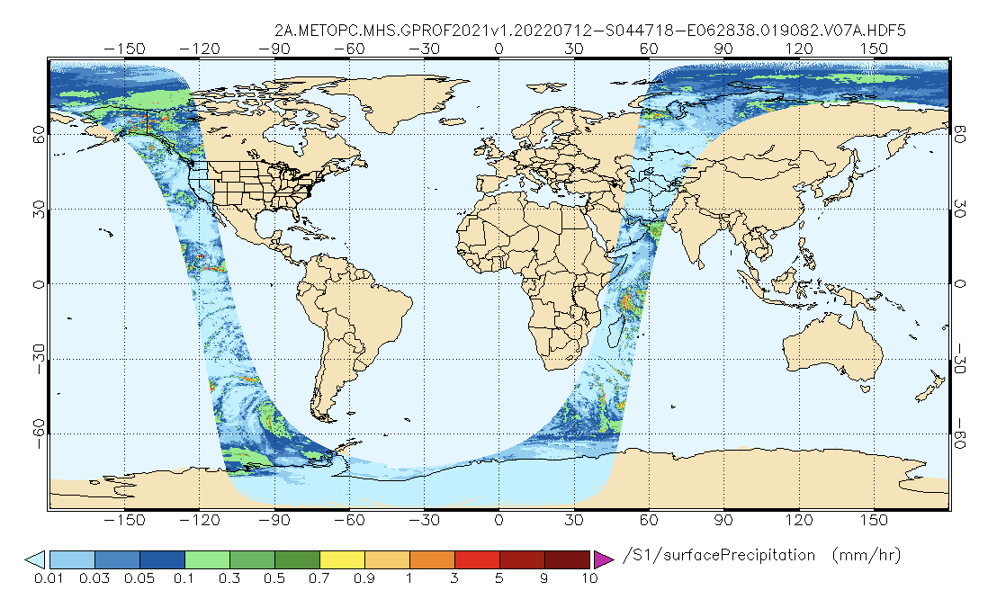
Federal
GPM MHS on METOP-C (GPROF) Radiometer Precipitation Profiling L2A 1.5 hours 17 km V07 (GPM_2AGPROFMETOPCMHS) at GES DISC
National Aeronautics and Space Administration —
Version 07 is the current version of the data set. The 2AGPROF (also known as, GPM GPROF (Level 2)) algorithm retrieves consistent precipitation and related science...

Official websites use .gov
A
.gov website belongs to an official government
organization in the United States.
Secure .gov websites use HTTPS
A
lock (
) or https:// means you’ve safely connected to
the .gov website. Share sensitive information only on official,
secure websites.