
-
Federal
MODIS/Aqua Thermal Anomalies/Fire 8-Day L3 Global 1km SIN Grid V006
National Aeronautics and Space Administration —
The MYD14A2 Version 6 data product was decommissioned on July 31, 2023. Users are encouraged to use the MYD14A2 Version 6.1 data product.The Aqua Moderate Resolution... -
Federal
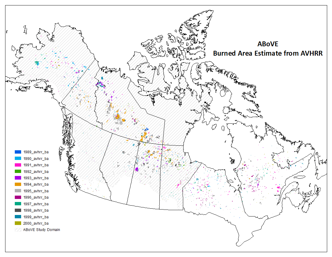
ABoVE: AVHRR-Derived Forest Fire Burned Area-Hot Spots, Alaska and Canada, 1989-2000
National Aeronautics and Space Administration —
This dataset provides annual forest fire burned area and daily hotspot products developed using data acquired from the Advanced Very-High-Resolution Radiometer... -
Federal
H10893: NOS Hydrographic Survey , Southern Approach to Port Nikiski, Alaska, 1999-07-08
National Oceanic and Atmospheric Administration, Department of Commerce —
The National Oceanic and Atmospheric Administration (NOAA) has the statutory mandate to collect hydrographic data in support of nautical chart compilation for safe... -
Federal
H10432: NOS Hydrographic Survey , Cook Inlet, Alaska, 1992-07-31
National Oceanic and Atmospheric Administration, Department of Commerce —
The National Oceanic and Atmospheric Administration (NOAA) has the statutory mandate to collect hydrographic data in support of nautical chart compilation for safe... -
Federal
NOAA GOES-R Series Advanced Baseline Imager (ABI) Level 2 Aerosol Detection (ADP)
National Oceanic and Atmospheric Administration, Department of Commerce —
The GOES-R Advanced Baseline Imager (ABI) Aerosol Detection product contains three images in the form of binary masks that identify the presence of aerosols, dust,... -
Federal
Digital Geologic-GIS Map of the Kayjay Quadrangle and Kentucky part of the Fork Ridge Quadrangle, Kentucky (NPS, GRD, GRI, CUGA, KAYJ digital map) adapted from a Kentucky Geological Survey Digitally Vectorized Geological Quadrangle map by Conley (2003) and a U.S. Geological Survey Geologic Quadrangle Map by Rice and Maughan (1978)
Department of the Interior —
The Digital Geologic-GIS Map of the Kayjay Quadrangle and Kentucky part of the Fork Ridge Quadrangle, Kentucky is composed of GIS data layers and GIS tables, and is... -
Federal
Digital Bedrock Geologic-GIS Map of New River Gorge National Park and Preserve, and Vicinity, West Virginia (NPS, GRD, GRI, NERI, NERI_bedrock digital map) adapted from a West Virginia Geological and Economic Survey Open-File Reports map by McColloch, Hunt, McColloch, Peck, Blake, Matchen, and Gooding (2013)
Department of the Interior —
The Digital Bedrock Geologic-GIS Map of New River Gorge National Park and Preserve, and Vicinity, West Virginia is composed of GIS data layers and GIS tables, and is... -
Federal
Alien Plant Survey Protocol Design
Department of the Interior —
Following a survey effort to describe alien plant invasion of anthropogenically disturbed areas, this project set the stage for inventorying areas of natural... -
Federal
Vegetation data from Valles Caldera National Preserve's Cerro Seco Unit 5 forest restoration project, 2016-2022
Department of the Interior —
Vegetation data files from the Cerro Seco Unit 5 forest restoration project (thinning, prescribed slash burning) during 2016-2022. -
Federal
Imagery data for the Vegetation Mapping Inventory Project of Fire Island National Seashore
Department of the Interior —
This reference contains the imagery data used in the completion of the baseline vegetation inventory project for the NPS park unit. Orthophotos, raw imagery, and... -
Federal
Fire Island National Seashore bathymetry survey, 2024.
Department of the Interior —
Multibeam sonar data collected with an EchoBoat 160 (Seafloor Systems inc.), an autonomous surface vessel (ASV), equipped with an iWBMSe mutibeam sonar (Norbit). Data... -
Federal
Imagery data for the Vegetation Mapping Inventory Project of Minidoka National Historic Site
Department of the Interior —
This reference contains the imagery data used in the completion of the baseline vegetation inventory project for the NPS park unit. Orthophotos, raw imagery, and... -
Federal
Micro-environmental study of soil temperature and moisture in proximity to logs during forest thinning and slash burning
Department of the Interior —
This data set was generated during a 7-year study of soil micro-environmental dynamics of temperature and moisture at 3 soil depths (10, 20 and 30 cm) beneath and... -
Federal
Unpublished Digital Post-Hurricane Sandy (2015) Geomorphological Map of Fire Island National Seashore and Vicinity, New York (NPS, GRD, GRI, FIIS, FIIS post-Hurricane Sandy digital map) adapted from a Rutgers University, Institute of Marine and Coastal Sciences map by Psuty, Schmelz, Greenberg, Beal and Spahn (2015)
Department of the Interior —
The Unpublished Digital Post-Hurricane Sandy (2015) Geomorphological Map of Fire Island National Seashore and Vicinity, New York is composed of GIS data layers and... -
Federal
SAFARI 2000 Physical and Chemical Properties of Aerosols, Dry Season 2000
National Aeronautics and Space Administration —
The Southern African Regional Science Initiative 2000 (SAFARI 2000) provided an opportunity to study aerosol particles produced by savanna burning. We used analytical... -
Federal
SAFARI 2000 ASTER and MODIS Fire Data Comparison, Dry Season 2001
National Aeronautics and Space Administration —
These data relate to a paper (Morisette et al., 2005) that describes the use of high spatial resolution ASTER data to determine the accuracy of the moderate... -
Federal
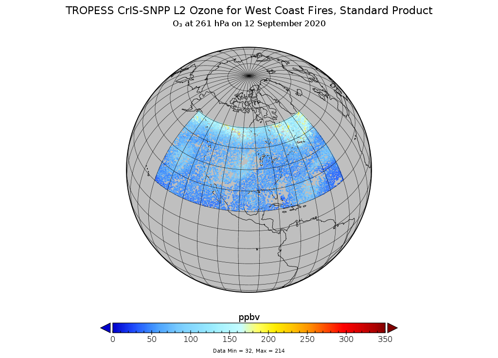
TROPESS CrIS-SNPP L2 Ozone for West Coast Fires, Standard Product V1 (TRPSDL2O3CRSWCF) at GES DISC
National Aeronautics and Space Administration —
The TROPESS CrIS-SNPP L2 Ozone for West Coast Fires, Standard Product contains the vertical distribution of the retrieved atmospheric state of ozone (O3), formal... -
Federal
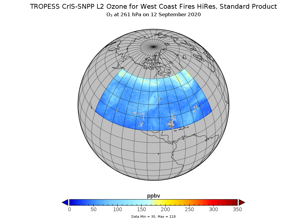
TROPESS CrIS-SNPP L2 Ozone for West Coast Fires HiRes, Standard Product V1 (TRPSDL2O3CRSWCFHI) at GES DISC
National Aeronautics and Space Administration —
The TROPESS CrIS-SNPP L2 Ozone for West Coast Fires HiRes, Standard Product contains the vertical distribution of the retrieved atmospheric state of ozone (O3),... -
Federal
TROPESS CrIS-SNPP L2 Carbon Monoxide for Forward Stream, Summary Product V1 (TRPSYL2COCRSFS) at GES DISC
National Aeronautics and Space Administration —
The TROPESS CrIS-SNPP L2 Carbon Monoxide for Forward Stream, Summary Product contains the vertical distribution of the retrieved atmospheric state of carbon monoxide...

Official websites use .gov
A
.gov website belongs to an official government
organization in the United States.
Secure .gov websites use HTTPS
A
lock (
) or https:// means you’ve safely connected to
the .gov website. Share sensitive information only on official,
secure websites.
.jpg)