
-
Federal
BOREAS AFM-06 Mean Wind Profile Data
National Aeronautics and Space Administration —
The BOREAS AFM-06 team from the National Oceanic and Atmospheric Administration Environment Technology Laboratory (NOAA/ETL) operated a 915 MHz wind/Radio Acoustic... -
Federal
CALIPSO Lidar Level 3 Stratospheric Aerosol Profiles Standard V1-01
National Aeronautics and Space Administration —
CAL_LID_L3_Stratospheric_APro-Standard-V1-01 is the Cloud-Aerosol Lidar and Infrared Pathfinder Satellite Observation (CALIPSO) Lidar Level 3 Stratospheric Aerosol... -
Federal
BOREAS Level-0 AOCI Imagery: Digital Counts in BIL Format
National Aeronautics and Space Administration —
The level-0 AOCI imagery, along with the other remotely sensed images, was collected to provide spatially extensive information about radiant energy over the primary... -
Federal
BOREAS HYD-03 Snow Water Equivalent Data
National Aeronautics and Space Administration —
The BOREAS HYD-03 team collected several data sets related to the hydrology of forested areas. This data set contains measurements of snow depth, snow density in 3-cm... -
Federal
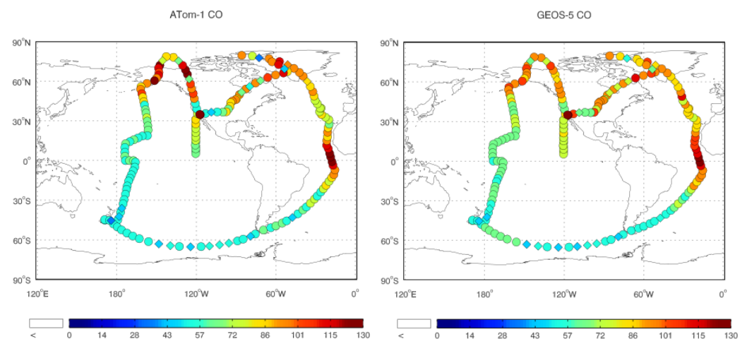
ATom: Observed and GEOS-5 Simulated CO Concentrations with Tagged Tracers for ATom-1
National Aeronautics and Space Administration —
This dataset contains carbon monoxide (CO) observations at 10-second intervals from flights during the ATom-1 campaign in 2016 and simulated CO concentrations from... -
Federal
Sounder SIPS: JPSS-1 CrIS Level 3 Specific Quality Control Gridded Daily CLIMCAPS V2 (SNDRJ1IML3SDCCP) at GES DISC
National Aeronautics and Space Administration —
WARNING: To users of the derived product “co_mmr_midtrop” (carbon monoxide mass mixing ratio to dry air [kg/kg] at ~500 hPa). This variable has a significant bias due... -
Federal
NPP Multi-Biome: Global Osnabruck Data, 1937-1981, R1
National Aeronautics and Space Administration —
This data set contains three files. The first file provides net primary productivity (NPP) estimates, vegetation characteristics, and summary climate data for 720... -
Federal
TROPESS CrIS-SNPP L2 Carbon Monoxide for West Coast Fires HiRes, Standard Product V1 (TRPSDL2COCRSWCFHI) at GES DISC
National Aeronautics and Space Administration —
The TROPESS CrIS-SNPP L2 Carbon Monoxide for West Coast Fires HiRes, Standard Product contains the vertical distribution of the retrieved atmospheric state of carbon... -
Federal
TROPESS CrIS-SNPP L2 Ozone for Forward Stream, Summary Product V1 (TRPSYL2O3CRSFS) at GES DISC
National Aeronautics and Space Administration —
The TROPESS CrIS-SNPP L2 Ozone for Forward Stream, Summary Product contains the vertical distribution of the retrieved atmospheric state of ozone (O3), and formal... -
Federal
LBA-ECO CD-10 H2O Profiles at km 67 Tower Site, Tapajos National Forest
National Aeronautics and Space Administration —
This data set reports vertical profiles of H2O vapor concentrations measured at the Para Western (Santarem) - km 67, Primary Forest Tower Site (Figure 1). This site... -
Federal
ISLSCP II Globalview: Atmospheric CO2 Concentrations
National Aeronautics and Space Administration —
The GlobalView Carbon Dioxide (CO2) data product contains synchronized and smoothed time series of atmospheric CO2 concentrations at selected sites that were created... -
Federal
AM Bench 2018 Residual Elastic Strain Measurements of 3D Additive Manufacturing Builds of IN625 Artifacts Using Neutron Diffraction and Synchrotron X-ray Diffraction
Department of Commerce —
The development of large residual elastic strains and stresses during laser powder-bed fusion (LPBF) additive manufacturing is one of the most significant barriers to... -
Federal
BOREAS Level-1B MAS Imagery: At-Sensor Radiance, Relative X and Y Coordinates
National Aeronautics and Space Administration —
For BOREAS, the MAS images, along with the other remotely sensed data, were collected to provide spatially-extensive information over the primary study areas. This... -
Federal
Sentinel-5P TROPOMI Ozone Profile 1-Orbit L2 30km x 30km V2 (S5P_L2__O3__PR_HiR) at GES DISC
National Aeronautics and Space Administration —
Starting from August 6th in 2019, Sentinel-5P TROPOMI along-track high spatial resolution (~5.5km at nadir) has been implemented. S5P_L2__O3__PR_HiR data collection... -
Federal
Polar Radiant Energy in the Far InfraRed Experiment (PREFIRE) Satellite 2 Raw Payload R01
National Aeronautics and Space Administration —
Polar Radiant Energy in the Far InfraRed Experiment (PREFIRE) Satellite 2 Raw Payload (PREFIRE_SAT2_0-PAYLOAD) contains the uncurated raw measurements from one of two... -
Federal
MLS/Aura Level 3 Daily Binned Relative Humidity With Respect To Ice (RHI) on Zonal and Similar Grids V004 (ML3DZRHI) at GES DISC
National Aeronautics and Space Administration —
ML3DZRHI is the EOS Aura Microwave Limb Sounder (MLS) daily binned on zonal and assorted vertical grids product for relative humidity with respect to ice (RHI)... -
Federal
GPM PR on TRMM Reflectivity, Precipitation Characteristics and Rate, at Surface and Profile L2 1.5 hours V07 (GPM_2APR) at GES DISC
National Aeronautics and Space Administration —
This is the new, GPM-like, format for TRMM Precipitation Radar L2 data that now incorporates what was known as 2A21, 2A23 and 2A25 datasets.The primary purpose of... -
Federal
GPM PR and TMI on TRMM Combined Convective-Stratiform Latent Heating Profiles L2 1.5 hours 5 km V07 (GPM_2HCSH_TRMM) at GES DISC
National Aeronautics and Space Administration —
This is a new (GPM-formated) TRMM product. The equivalent old TRMM legacy product is TRMM_2H31.Version 07 is the current version of the data set. Older versions will... -
Federal
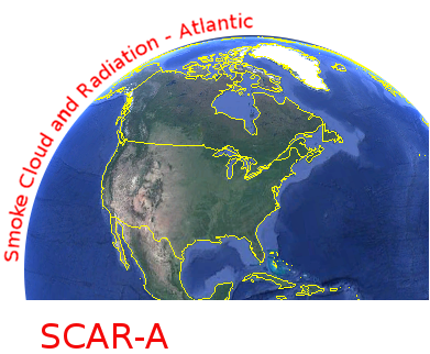
CAR SCAR-A Sulfates, Clouds, and Radiation-Atlantic BRDF Measurements BRDF V2 (CAR_SCARA_BRDF) at GES DISC
National Aeronautics and Space Administration —
The objectives for the SCAR mission are to advance our knowledge of how the physical, chemical and radiative processes in our atmosphere are affected by sulfate...

Official websites use .gov
A
.gov website belongs to an official government
organization in the United States.
Secure .gov websites use HTTPS
A
lock (
) or https:// means you’ve safely connected to
the .gov website. Share sensitive information only on official,
secure websites.